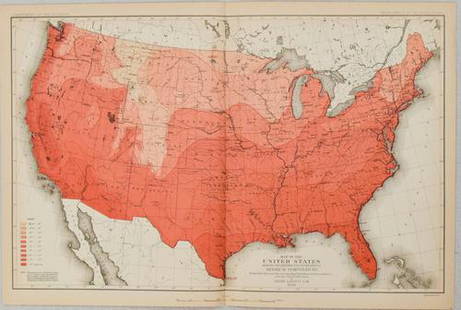
Sold20201880 US Government Map of US Population Distribution --Title/Content of Map: 1880 US Government Map of US Population Distribution -- Distribution of the Population (Excluding Indians Not Taxed) Cartographer: US Department of the Interior Year/Place: 1880See Sold Price
Sold20211840 US Government Map of US Population Distribution --Title: 1840 US Government Map of US Population Distribution -- Distribution of the Population East of the 100th Meridian: 1840 Cartographer: US Department of the Interior Year / Place: 1900 Map DimensSee Sold Price
Sold20231830 US Government Map of US Population Distribution -- Distribution of the Population East of theTitle: 1830 US Government Map of US Population Distribution -- Distribution of the Population East of the 100th Meridian: 1830 Cartographer: US Department of the Interior Year/Place: 1900 Dimensions:See Sold Price
Sold20221900 US Government Map of US Urban PopulationTitle: 1900 US Government Map of US Urban Population Distribution -- Proportion of Population in Cities and Towns of More than 2000 Inhabitants at the Twelfth Census 1900 Cartographer: US Department oSee Sold Price
Sold20201900 US Government Map of Proportion of AfricanTitle: 1900 US Government Map of Proportion of African American Population -- Proportion of Negro Total Population of the United States at the Twelfth Census 1900 Cartographer: US Department of the InSee Sold Price
Sold20221900 US Government Map of Proportion of WhiteTitle: 1900 US Government Map of Proportion of White Illiterates Population -- Proportion of Illiterates Among Native White Voters of the United States at the Twelfth Census 1900 Cartographer: US DepaSee Sold Price
Sold20211900 US Government Map of Typhoid Fever Death Rates inTitle: 1900 US Government Map of Typhoid Fever Death Rates in New England To New York and New Jersey -- The Death Rate Due to Typhoid Fever per 100,000 of Population 1900 Cartographer: US Department oSee Sold Price
Sold20231880 US Census Map of Corn Production per Capita -- Map of the United States Showing theTitle: 1880 US Census Map of Corn Production per Capita -- Map of the United States Showing the Distribution of Production of Indian Corn in Bushels per Capita… Cartographer: US Census Bureau YeSee Sold Price
Sold20231880 US Census Map of Wheat Production per Capita -- Map of the United States Showing theTitle: 1880 US Census Map of Wheat Production per Capita -- Map of the United States Showing the Distribution of Production of Wheat in Bushels per Capita… Cartographer: US Census Bureau Year /See Sold Price
Sold20231880 US Census Map of Oats Production per Capita -- Map of the United States Showing theTitle: 1880 US Census Map of Oats Production per Capita -- Map of the United States Showing the Distribution of Production of Oats in Bushels per Capita… Cartographer: US Census Bureau Year / PlSee Sold Price
Sold20241880 Map of US Wheat Farming -- Map of the United States Showing the Distribution of Production ofTitle: 1880 Map of US Wheat Farming -- Map of the United States Showing the Distribution of Production of Wheat in Bushels per Capita…at Tenth Census Cartographer: Department of Interior Year /See Sold Price
Sold2018Rand McNally: Antique US Population Trend Map, 1892Title/Content of Map: 1892 Rand McNally US Population Trend Map -- Rand McNally & Co.'s Map of the United States Showing the Increase and Decrease of Population 1880 to 1890 Date Printed: 1892, ChicagSee Sold Price
Sold20211880 Gannett Climate Map of the US with IsothermalTitle: 1880 Gannett Climate Map of the US with Isothermal Minimum Temperature Lines -- Map of the United states Showing the Distribution of Lines of Minimum Temperature… Cartographer: H Gannett / DeSee Sold Price
Sold20221900 US Government Map of US Manufacturing Output -- Value of Products of Manufacturers Per SquareTitle: 1900 US Government Map of US Manufacturing Output -- Value of Products of Manufacturers Per Square Mile at the Twelfth Census 1900 Cartographer: US Department of the Interior Year / Place: 1900See Sold Price
Sold2022Three Antique Hawaiian Maps, US Government3 1920s Hawaiian Maps. Island Of Oahu Map Approximately 47.1875 x 36.5 in. Hawaiian Islands Approximately 45.875 x 35.125 in. Hawaii To Oahu Approximately 46.4375 x 35.5625 in.See Sold Price
Sold20181880 Gray US Map -- Gray's New Map of the United StatesReserve Reduced! Title/Content of Map: 1880 Gray US Map -- Gray's New Map of the United States Date: 1880, Philadelphia Cartographer: F Gray Size: 15.5 x 26.7 in. A very nice large US map, showing greSee Sold Price
Sold20181880 Gray US Map -- Gray's New Map of the United StatesTitle/Content of Map: 1880 Gray US Map -- Gray's New Map of the United States Date: 1880, Philadelphia Cartographer: F Gray Size: 15.5 x 26.7 in. A very nice larger US map, showing great deal of topogSee Sold Price
Sold20191880 Gray US Map -- Gray's New Map of the United StatesTitle/Content of Map: 1880 Gray US Map -- Gray's New Map of the United States Date: 1880, Philadelphia Cartographer: F Gray Size: 15.5 x 26.7 in. A very nice large US map, showing great deal of topogrSee Sold Price
Sold20221900 US Government Map of Improved Lands -- ProportionTitle: 1900 US Government Map of Improved Lands -- Proportion of Improved Land to Total Area at the twelft Census 1900 Cartographer: US Department of the Interior Year/Place: 1900 Dimensions: 8.3 X 12See Sold Price
Sold20221880 US Census Map of Oats Production -- Map of the United States Showing the Average Yield of OatsTitle: 1880 US Census Map of Oats Production -- Map of the United States Showing the Average Yield of Oats per Acre… Cartographer: US Census Bureau Year / Place: 1880, Boston Map Dimension (in.)See Sold Price
Sold20231880 US Census Map of Barley Production -- Map of the United States Showing the Average Yield ofTitle: 1880 US Census Map of Barley Production -- Map of the United States Showing the Average Yield of Barley per Acre… Cartographer: US Census Bureau Year / Place: 1880, Boston Map Dimension (See Sold Price
Sold20211890 US Population MapAuthor: Cram Title: 1890 US Population Ma Medium: Ink on Paper Dimensions: 14.5"X11.5" Map of the Centers of Population in the US between 1790 and 1890. Dated 1890. Engraved and published by George CrSee Sold Price
2018U.S GOVERNMENT SURVEY COPPER MAP PLATES, SET OF 3Park Ridge, NJ-NY US Government Copper Map Engravings for Park Ridge, NJ-NY, scale 1:31,680 surveyed 1934-1944. The Original Master Set engraved on 3 plates measures approximately 21 in. H x 17 in. W.See Sold Price
Sold20211900 US Population Density MapAuthor: Mc Nally Title: 1900 US Population Density Map Medium: Ink on Paper Dimensions: 21"X14.5" US population density map dated 1900. Printed and published by the Rand McNally Co. Part of the IndexeSee Sold Price
Oct 22The Ross Art GroupYou Can't Afford to Miss Either - Buy Bonds Original Vintage WWII Poster by Sawyers c1942$500
Oct 22The Ross Art GroupOriginal World War ll 1943 Poster - Back the Attack by George Schreiber - Medium Size$450
Oct 13JM Hobby Supply and Railroad Artifact AuctionsUSOX/SHELL/BELCHER 5 Car Tank Car Kit Set-Intermountain Railway-HO Scale$10(1 bid)
2 days LeftSimpson Galleries, LLC.WILLIAM JAMES STONE (1800-1865) A REPUBLIC OF TEXAS OFFICIAL U.S. BOUNDARY MAP, "Map of the river$300
2 days LeftCheck the Oil Promotions, LLCTexaco Travel Service Advertising Map Rack with 15 Maps$55(5 bids)
1 day LeftSofe Design AuctionsRare & Fine 1804 Dated English High Government Official's or Diplomat's Dress Sword Rapier,$500
Oct 26Sofe Design AuctionsRare Map with the marking of Sea of Korea/East Sea by Jacques Nicolas Bellin ? 18th Century.$100
1 day LeftSimpson Galleries, LLC.A CARSON CITY, U.S. MINT BAG AND UNCIRCULATED 1883 SILVER DOLLAR, AMERICAN, NEVADA, 1880s$500


![[CIVIL WAR] m1860 (1863) Cavalry Sabre by Emerson (1 of 4)](https://p1.liveauctioneers.com/7226/343781/186766828_1_x.jpg?height=282&quality=70&version=1726333566)
![[CIVIL WAR] m1860 (1862) Cavalry Sabre by Emerson (1 of 2)](https://p1.liveauctioneers.com/7226/343781/186766829_1_x.jpg?height=282&quality=70&version=1726333566)

![[WORLD WAR II]. Group of 16 US Army Recruitment & War Bonds... (1 of 7)](https://p1.liveauctioneers.com/928/342606/186002982_1_x.jpg?height=282&quality=70&version=1725643038)
![[WORLD WAR II]. Group of 15 US Army Recruitment & War Bonds... (1 of 6)](https://p1.liveauctioneers.com/928/342606/186002981_1_x.jpg?height=282&quality=70&version=1725643038)


