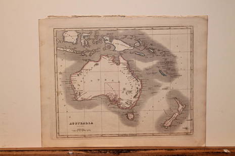
20201842 Map of AustraliaAuthor: Scott Title: 1842 Map of Australia Medium: Ink on Paper Dimensions: 11.5X9" Description: Map of Australia dated 1842. Copper plate map. Engraved by R. Scott. Published by Thomas Nelson in EdinSee Sold Price
Sold20201842 Map of AustraliaAuthor: Scott Title: 1842 Map of Australia Medium: Ink on Paper Dimensions: 11.5"X9" Map of Australia dated 1842. Copper plate map. Engraved by R. Scott. Published by Thomas Nelson in Edinburgh. PartSee Sold Price
Sold2022MAP, Australia, BellinA Rare Pre-Cook Map Focusing on Australia. Australia. Jacques Nicolas Bellin, Carte Reduite des Terres Australes pour Servir a l'Histoire des Voyages, from Prevost's Histoire Generale des Voyages, 175See Sold Price
Sold20241783 Captain James Cook Third Pacific Voyage Illustrated MAP Australia Rickman1783 Captain James Cook Third Pacific Voyage Illustrated MAP Australia Rickman “Remember, the greater the opportunity, the fewer are those who see it.” – James Cook James Cook was an 18th-ceSee Sold Price
Sold2021Tallis, John (Pub) 1852 Map. AustraliaSteel Engraved Map with Original Outline Hand Color Published 1852-56 by John Tallis, London for "The Universal Pronouncing Dictionary" by Thomas Wright. Drawn & Engraved by John Rapkin. Centre fold aSee Sold Price
Sold2024West India Islands. Caribbean. La Salle settlement in Texas. LIZARS 1842 mapTITLE/CONTENT OF MAP: 'West India Islands and adjacent coasts of the United States, Mexico, Guatimala & Colombia' The map notes anecdotally the location of René Robert Cavelier, Sieur de La SalleSee Sold Price
Sold2023South America /Atlantic Ocean. Gran Colombia. United Provinces. LIZARS 1842 mapTitle: South America /Atlantic Ocean. Gran Colombia. United Provinces. LIZARS 1842 map Description: South America' by William Home Lizars (1842). Antique 19th century atlas map with original hand coloSee Sold Price
Sold2024Russell, J. 1804 Antique Map. AustraliaCopper Engraved Map with outline hand color Published 1804 by W. Peacock, London for "A Compendious Geographical Dictionary" Drawn and Engraved by J. Russell. Folds as issued. Paper Size: 6.5 x 5 inchSee Sold Price
Sold20201842 map of New York City, Sidney MorseFrom the very first cerographic atlas ever published. Two tiny very lightly discolored areas at top edge; corner crease. 12 x 15. Reserve: $90.00 Shipping: Domestic: Flat-rate of $6.00 to anywhere witSee Sold Price
Sold2023Thomson, John (Pub) 1825 Map. AustraliaCopper Engraved Map Published 1825 by John Thomson, Edinburgh for "The Edinburgh School Atlas" by N. R. Hewitt. Maps Engraved by Hewitt. Original Outline Hand Colour. Rare. Paper Size: 10.5 x 8 inch (See Sold Price
Sold2023Lizars, Daniel 1831 LG Rare HC Map. AustraliaLarge Folio Copper Engraved Map Published 1831-2 by John Hamilton, Successor to Daniel Lizars, Edinburgh for "The Edinburgh Geographical and Historical Atlas..." First Edition by Daniel Lizars. Very fSee Sold Price
Sold20201842 Map of North AmericaAuthor: Scott Title: 1842 Map of North America Medium: Ink on Paper Dimensions: 9"X11.5" Map of North America dated 1842. Engraved by R. Scott. Part of the New General Atlas of the World. Published bySee Sold Price
Sold2023MAP, Australia, SDUKWestern Australia & Tasmania. SDUK Society for the Diffusion of Useful Knowledge, Western Australia Containing the Settlements of Swan-River and King George's Sound... [on sheet with] Van-Diemen IslanSee Sold Price
Sold20201842 Map of AsiaAuthor: Scott Title: 1842 Map of Asia Medium: Ink on Paper Dimensions: 11.5"X 9" Description: Map of Asia dated 1842. Copper plate map. Engraved by R. Scott. Published by Thomas Nelson in Edinburgh. PSee Sold Price
Sold2022Rapkin, John 1860 Antique Map. AustraliaSteel Engraved Map Published 1860 by The London Printing & Published Company, London for "The Royal Dictionary-Cyclopedia for Universal Reference" by Thomas Wright. Drawn & Engraved by John Rapkin. FoSee Sold Price
Sold20201842 Map of AfricaAuthor: Scott Title: 1842 Map of Africa Medium: Ink on Paper Dimensions: 11.5 X 9" Description: Map of Africa dated 1842. Copper plate map. Engraved by R. Scott. Published by Thomas Nelson in EdinburgSee Sold Price
Sold20201842 Map of North AmericaTitle: 1842 Map of North America Author: Nelson Medium: Ink on Paper Dimensions: 9"X11.5" Description: Map of North America dated 1842. Engraved by R. Scott. Part of the New General Atlas of the WorldSee Sold Price
Sold2022Barclay & Becker C1845 Map. AustraliaSteel Engraved Map Published C1845, London for "A Complete and Universal English Dictionary" by the Rev. James Barclay and B. B. Woodward. Maps by F. P. Becker. Outline hand colour. Paper Size: 10.5 xSee Sold Price
Sold2023Beeton, Samuel 1868 Antique Map. AustraliaLithograph Maps Published 1868, London for "Beeton’s Dictionary Of Geography" by Samuel Orchart Beeton. Folds as issued. Paper Size: 10 x 8 inch (26 x 20cm) Good ConditionSee Sold Price
Sold20201842 Map of ChinaAuthor: Scott Title: 1842 Map of China Medium: Ink on Paper Dimensions: 9"X11.5" Description: Map of China dated 1842. Copper plate map. Engraved by R. Scott. Published by Thomas Nelson in Edinburgh.See Sold Price
Sold20211842 Map of FranceAuthor: Scott Title: 1842 Map of France Medium: Ink on Paper Dimensions: 11.5"X9" Map of France engraved by R. Scott dated 1842. Part of the New General Atlas of the World. Published by Thomas NelsonSee Sold Price
Sold20211842 Map of GreeceAuthor: Scott Title: 1842 Map of Greece Medium: Ink on Paper Dimensions: 11.5"X9" Map of Greece dated 1842. Engraved by R. Scott. Part of the New General Atlas of the World. Copper plate engraving. PuSee Sold Price
Sold2024Rapkin, John 1860 Antique Map. AustraliaSteel Engraved Map Published 1860 by The London Printing & Published Company, London for "The Royal Dictionary-Cyclopedia for Universal Reference" by Thomas Wright. Drawn & Engraved by John Rapkin. FoSee Sold Price
Sold20211842 Map of the East IndiesAuthor: Scott Title: 1842 Map of the East Indies Medium: Ink on Paper Dimensions: 11.5"X9" Map of the East Indies dated 1842. Engraved by R. Scott. Part of the New General Atlas of the World. Copper pSee Sold Price
1 day LeftJasper52AUSTRALIA.Sydney view.Pre-Queensland (est 1859).Counties.TALLIS/RAPKIN 1849 map$260
1 day LeftJasper52Carte réduite des Terres Australes'. Pre-Cook Australia. BELLIN/SCHLEY 1758 map$550
1 day LeftJasper52AUSTRALIAN COLONIES w/ counties. Predates Queensland (Est. 1859). SDUK 1857 map$380
1 day LeftJasper52Océanique. Partie… Nlle Hollande #56. Victoria S Australia VANDERMAELEN 1827 map$260
1 day LeftJasper52Océanique. Partie de la Nle Hollande #44 Western Australia VANDERMAELEN 1827 map$300
1 day LeftJasper52Océanique Partie de la Nlle Hollande #35 Western Australia VANDERMAELEN 1827 map$300
1 day LeftJasper52Océanique. Nlle Hollande 50 Gascoyne Western Australia VANDERMAELEN 1827 map$300
Featured1 day LeftJasper52Americae / America by Bertius / Langenes. The Americas 1603 old antique map$460
1 day LeftJasper52Océanique. Partie… Nle Hollande #52. Western Australia SW. VANDERMAELEN 1827 map$320
Oct 01Jasper521723 Dampier Map of Voyages to Brazil, Australia and Eat Indies -- Voyage du Cap. Dampier a la N.$280
1 day LeftJasper52Océanique Partie… Nle Hollande #53 W Australia Goldfields. VANDERMAELEN 1827 map$300
1 day LeftJasper52Océanique. Partie… Nlle Hollande #54 South Australia coast VANDERMAELEN 1827 map$320
1 day LeftJasper52Carte réduite des Terres Australes'. Pre-Cook Australia & NZ. BELLIN 1753 map$600
25 mins LeftJasper521814 Carey Map of Southeast Asia and Northern Australia -- The Islands of the East Indies with the$110
Featured25 mins LeftJasper521787 Bonne Map of the Spice Island, Other Parts Indonesia and the Philippines -- La Presqu' Isle de$80


![MAP, Australia, SDUK: Western Australia & Tasmania. SDUK Society for the Diffusion of Useful Knowledge, Western Australia Containing the Settlements of Swan-River and King George's Sound... [on sheet with] Van-Diemen Islan](https://p1.liveauctioneers.com/6576/279721/147265559_1_x.jpg?height=310&quality=70&version=1677104593)


