Sold20201889 Map of New YorkAuthor: Cram Title: 1889 Map of New York Medium: Ink on PaperDimensions: 11.5"X14.5" Map of the lower half of New York City dated 1889. Engraved and published by George Cram in Chicago. Part of his StSee Sold Price
Sold20241889 Five Years at Panama. The Trans-IsthmianFive Years at Panama. The Trans-Isthmian Canal by Wolfred Nelson, M.D. Belford Company, Publishers, New York, 1889, folding frontis map, 287 pp, green decorative cloth, 8 x 5.5", 8vo. Good condition.See Sold Price
Sold2023MISC. HISTORICAL BOOKSDARWINISM AN EXPOSITION OF NATURAL SELECTION by Alfred Russell Wallace New York 1889 – With map and illustrations ARIZONA HISTORICAL REVIEW (Vol. 3 #3) July 1936 THE PEOPLES PICTORIAL EDITION.See Sold Price
Sold20201889 Map of New OrleansAuthor: Fisk Title: 1889 Map of New Orleans Medium: Ink on Paper Dimensions: 11.5"X14" Map of New Orleans dated 1889. Engraved by Fisk and Company. Published by Hunt and Eaton in New York. Key lower rSee Sold Price
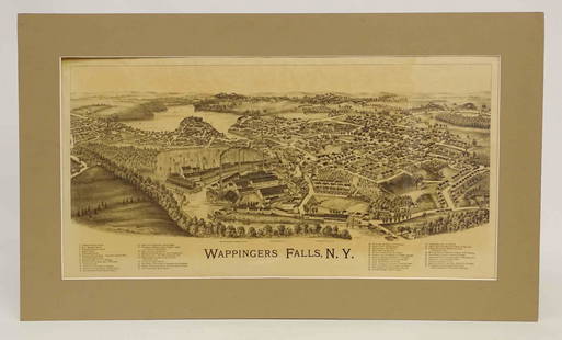
Sold2022Wappingers Falls New York Large ViewWappingers Falls, N.Y. Large Panorama Bird's-eye Map. L.R. Burleigh, Troy, New York, c. 1889. Antique print. 15" x 29".See Sold Price
Sold2017Antique Arbuckles’ 1889 Victorian # 66 Texas State CardThis Arbuckles’ 1889 Victorian No. 66 Texas State Card. This Arbuckle Bros. Coffee Co. Texas State Trade Card no.66: Map and Vignette Illustrations is in very good condition. Marked New York.: ArbucSee Sold Price
Sold2021Antique Arbuckle Bros. Coffee Co. Washington StateThis Arbuckle Bros. Coffee Co. Washington State Trade Card no.78: Map and Vignette Illustrations is in very good condition. Marked New York.: Arbuckle Bros. Coffee Co. 1889. Trade card, 3 x 5 inches,See Sold Price
Sold2023CHINA JEFFERSON (LOUISE E.) China. A Friendship Map, New York, Friendship Press, Inc., 1948CHINA JEFFERSON (LOUISE E.) China. A Friendship Map, pictorial colour printed map, numerous illustrations of famous sites, industries, and views, six portraits (including Sun Yat-sen, Chiang Kai-shekSee Sold Price
Sold201510 Maps: New York street grid, views, US, MD[New York/Maryland/US] 10 Maps. 8 1/8 x 9 3/4 in. to 17 7/8 x 27 1/2 in. Sold with all faults. ++ MAP OF THE CITY OF NEW-YORK 1852. Folding map from an annual edition of Valentine’s Manual. ++ PARTSee Sold Price
Sold2019Large map, New York City's UWS, 1879Large map, New York City's UWS, 1879, "West End Plateau of New York" by Herman K. Viele, City Surveyor, printed by Johnson & Pratt, New York, 1879, framed under acrylic, with 25-page booklet in pocketSee Sold Price
Sold2017Antique Map: New York & Area - EngravingPensylvania Nova Jersey et Nova York cum Regionibus Ad Fluvium Delaware In America Sitis, Nova Delinatione ob oculos posita...Tobias Conrad Lotter (1717 - 1777). Engraved map with hand-color in part.See Sold Price
Sold2023M. Dripps 1860 Map New York City County & Vacinity By M. DrippsM. Dripps 1860 Map New York City County & Vacinity By M. Dripps 22.5" x 30"See Sold Price
Sold2022Book: "1889 New York Herald Bound Newpapers, 24" x 14Book: "1889 New York Herald Bound Newpapers, 24" x 14 1/2".See Sold Price
Sold2016Map, New York Harbor, G. Mathiot, 1886This map depicts the New York Bay and Harbor area as of 1886, printed with color and with as accurate as possible scaling and measurements of depth given the time period. The top left denotes the yearSee Sold Price
Sold2018Antique Wall Map NEW YORK POSTAL ROUTES 1898 MailDetails: This large hanging wall map of postal routes in the state of New York was created by topographer A. von Haake, and printed by "Julius Bien & Co., Photo. Lith." Dated March, 1, 1898, this mapSee Sold Price
Sold2016Antique Map : New York, New Jersey - 1870Antique Map : New York, New Jersey, Pennsylvania, Ohio, Delaware, Maryland , Virginia & West Virginia - 1870 Size : 15.5" x 18.5"See Sold Price
Sold2019Pan Am Pan American Flight Map New York CaribbeanTitle/Content of Map: Pan Am Pan American Flight Map New York Caribbean Date: c1960 Cartographer: ANONYMOUS Publisher: PAN AM AIRLINES Size: 24.25Height - 14.5Width Seat-back pocket map for flights toSee Sold Price
Sold2020LYNN THOMAS MORGAN (b. 1889, New York) PortraitWatercolor on paper 21 1/2 x 13 1/2 in. (sight), 28 x 20 in. (framed)See Sold Price
Sold2022Encyclo. Britannica C1880 Lot 3 Maps. New York City & StateTwo City Plans and a State Map. Lithograph Maps Published 1875-98, Edinburgh & London for "Encyclopaedia Britannica" Ninth Edition. Paper Size: 10.5 x 8 inch (27 x 21cm) and 15.5 x 10.5 inch (39 x 27cSee Sold Price
Sold2021Lot Antique Maps New York New JerseyLot of Antique Maps Of New York, New Jersey & Massachusetts. Includes 11 maps from 19th century. Largest map measures 20 inches in height by 23 inches in width. This sale is online only - no public prSee Sold Price
Sold2023Weller, F. S. 1894 Antique Map. New York and EnvironsLithograph Map Published 1891-94 by Cassell & Co., London for "Cassell's Encyclopaedia A Storehouse of General Information" by Various Authors. Map by F. S. Weller. Folds as issued. Paper Size: 11 x 9See Sold Price
7 days LeftJasper521902 Cram Map of New York City [verso] Washington DC [verso] Baltimore -- New York [verso]$60
Jun 08Early American History Auctions1776 Map, PARTIE ORIENTALE DU CANADA, AVEC LA NOUVELLE ANGLETERRE, L'ACADIE... by P. Santini, Framed$950
Jun 18DOYLE Auctioneers & AppraisersA rare transformation card deck from the Kinney Brothers Tobacco Company$300


![10 Maps: New York street grid, views, US, MD: [New York/Maryland/US] 10 Maps. 8 1/8 x 9 3/4 in. to 17 7/8 x 27 1/2 in. Sold with all faults. ++ MAP OF THE CITY OF NEW-YORK 1852. Folding map from an annual edition of Valentine’s Manual. ++ PART](https://p1.liveauctioneers.com/179/82189/42599761_1_x.jpg?height=310&quality=70&version=1447864785)


![1902 Cram Map of New York City [verso] Washington DC [verso] Baltimore -- New York [verso] (1 of 3)](https://p1.liveauctioneers.com/5584/331064/178466310_1_x.jpg?height=282&quality=70&version=1716924723)


