Sold2021Lochhead (Pub) 1811 Rare Map. AfricaCopper Engraved Map Published 1811 by William Lochhead, Berwick for "Modern Geography: And a Compendious General Gazetteer" Rare. Folds as issued. Paper Size: 12 x 10 inch (30 x 26cm) Very minor toninSee Sold Price
Sold2021Lochhead (Pub) 1811 Rare Map. Mexico, West Indies, USA"New Mexico New Spain with the West Indies" Showing Unmapped Southern States around the Guld of Mexico, New Mexico, Mexico, New Spain, Cuba, Haiti and The West Indies. Copper Engraved Map Published 18See Sold Price
Sold2021Lochhead (Pub) 1811 Rare Map. World HemisphereCopper Engraved Map Published 1811 by William Lochhead, Berwick for "Modern Geography: And a Compendious General Gazetteer" Rare. Folds as issued. Paper Size: 17 x 11 inch (43 x 28cm) Some creasing. VSee Sold Price
Sold2021Lochhead (Pub) 1811 Rare Map. Russia in Europe"The Southern Part of Russia in Europe with Russian and Little Tartary" Copper Engraved Map Published 1811 by William Lochhead, Berwick for "Modern Geography: And a Compendious General Gazetteer" RareSee Sold Price
Sold2021Lochhead (Pub) 1811 Rare Map. IrelandCopper Engraved Map Published 1811 by William Lochhead, Berwick for "Modern Geography: And a Compendious General Gazetteer" Rare. Folds as issued. Paper Size: 10 x 8.5 inch (26 x 22cm) Very minor toniSee Sold Price
Sold2021Lochhead (Pub) 1811 Rare Map. AsiaCopper Engraved Map Published 1811 by William Lochhead, Berwick for "Modern Geography: And a Compendious General Gazetteer" Rare. Folds as issued. Paper Size: 12 x 10 inch (30 x 26cm) Very minor toninSee Sold Price
Sold2021Lochhead (Pub) 1811 Rare Map. EgyptCopper Engraved Map Published 1811 by William Lochhead, Berwick for "Modern Geography: And a Compendious General Gazetteer" Rare. Folds as issued. Paper Size: 11 x 8.5 inch (28 x 22cm) Good ConditionSee Sold Price
Sold2021Lochhead (Pub) 1811 Rare Map. South America"The Southern Part of South America" Copper Engraved Map Published 1811 by William Lochhead, Berwick for "Modern Geography: And a Compendious General Gazetteer" Rare. Folds as issued. Paper Size: 10.5See Sold Price
Sold2021Lochhead (Pub) 1811 Rare Map. FranceCopper Engraved Map Published 1811 by William Lochhead, Berwick for "Modern Geography: And a Compendious General Gazetteer" Rare. Folds as issued. Paper Size: 11 x 10 inch (28 x 26cm) Good ConditionSee Sold Price
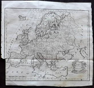
Sold2021Lochhead (Pub) 1811 Rare Map. EuropeCopper Engraved Map Published 1811 by William Lochhead, Berwick for "Modern Geography: And a Compendious General Gazetteer" Rare. Folds as issued. Paper Size: 12 x 10.5 inch (30 x 27cm) Some tone spotSee Sold Price
Sold2021Lochhead (Pub) 1811 Rare Map. ItalyCopper Engraved Map Published 1811 by William Lochhead, Berwick for "Modern Geography: And a Compendious General Gazetteer" Rare. Folds as issued. Paper Size: 10.5 x 10 inch (27 x 26cm) Very minor tonSee Sold Price
Sold2021Lochhead (Pub) 1811 Rare Map. England and WalesCopper Engraved Map Published 1811 by William Lochhead, Berwick for "Modern Geography: And a Compendious General Gazetteer" Rare. Folds as issued. Paper Size: 10.5 x 9.5 inch (27 x 24cm) Very minor toSee Sold Price
Sold2021Lochhead (Pub) 1811 Rare Map. Netherlands Holland"The Severn United Provinces with the Dutch and Austrian Netherlands" Copper Engraved Map Published 1811 by William Lochhead, Berwick for "Modern Geography: And a Compendious General Gazetteer" Rare.See Sold Price
Sold2021Lochhead (Pub) 1811 Lot of 3 Ethnic/Costume PrintsCopper Plates Published 1811 by William Lochhead, Berwick for "Modern Geography: And a Compendious General Gazetteer" Rare. Paper Size: 8 x 5 inch (21 x 13cm) Very minor toning. One with tiny Ink annoSee Sold Price
Sold2023Thomson, John (Pub) 1825 Map. AfricaCopper Engraved Map Published 1825 by John Thomson, Edinburgh for "The Edinburgh School Atlas" by N. R. Hewitt. Maps Engraved by Hewitt. Original Outline Hand Colour. Rare. Paper Size: 10.5 x 8 inch (See Sold Price
Sold2023Ptolemy, Fries, pub. 1535 - Map of Northern Africa and EgyptThis important historic map is from Geographicae enarrationis libri octo Ex Bilibaldi Pirckeymheri tralatione, fed ad Graeca & prisca exemplaria.... The work was published in 1535 in Lyon after LorenzSee Sold Price
Sold2021Lochhead (Pub) 1811 Astronomy Print. Armillary SphereCopper Plate Published 1811 by William Lochhead, Berwick for "Modern Geography: And a Compendious General Gazetteer" Paper Size: 8 x 5 inch (21 x 13cm) Some text offsettingSee Sold Price
Sold2021Lochhead (Pub) 1811 George Washington Benjamin Franklin"Benj. Franklin, LLD. FRS." and "General Washington" Copper Plates Published 1811 by William Lochhead, Berwick for "Modern Geography: And a Compendious General Gazetteer" Paper Size: 8 x 5 inch (21 xSee Sold Price
Sold2021Lochhead (Pub) 1811 Astronomy Print. Armillary SphereCopper Plate Published 1811 by William Lochhead, Berwick for "Modern Geography: And a Compendious General Gazetteer" Paper Size: 8 x 5 inch (21 x 13cm) Very minor toning. Good ConditionSee Sold Price
Sold2021Tallis, John (Pub) 1852 Map. AfricaSteel Engraved Map with Original Outline Hand Color Published 1852-56 by John Tallis, London for "The Universal Pronouncing Dictionary" by Thomas Wright. Drawn & Engraved by John Rapkin. Centre fold aSee Sold Price
Sold2021Thomson, John (Pub) 1825 Map. AfricaCopper Engraved Map Published 1825 by John Thomson, Edinburgh for "The Edinburgh School Atlas" by N. R. Hewitt. Maps Engraved by Hewitt. Engraved Vignette in corner. Original Outline Hand Colour. RareSee Sold Price
Sold2023Lizars, Daniel 1831 LG Rare HC Map. Africa on 2 SheetsLarge Folio Copper Engraved Map Published 1831-2 by John Hamilton, Successor to Daniel Lizars, Edinburgh for "The Edinburgh Geographical and Historical Atlas..." First Edition by Daniel Lizars. Very fSee Sold Price
Sold2021Tallis, John (Pub) 1852 Map. Africa ContinentSteel Engraved Map with Original Outline Hand Color Published 1852-56 by John Tallis, London for "The Universal Pronouncing Dictionary" by Thomas Wright. Drawn & Engraved by John Rapkin. Centre fold aSee Sold Price
Sold2024Russell & Allen (Pub) 1812 Map. AfricaFolio Copper Engraved Map Published 1812 by Russell and Allen, Manchester for "A New And Commercial System Of Geography" Paper Size: 15.5 x 9 inch (39 x 23cm) Minor toning. Good ConditionSee Sold Price
6 days LeftTrillium Antique Prints & Rare BooksCarey, pub. 1796 - Map of the State of New Jersey$75(1 bid)
6 days LeftTrillium Antique Prints & Rare BooksCarey, pub. 1796 - 3 Maps of States in North America$75(1 bid)
6 days LeftTrillium Antique Prints & Rare BooksDe Jode, Rare, pub. 1593 - Map of Asia (Tertiae Partis Asiae)$100(1 bid)
6 days LeftTrillium Antique Prints & Rare BooksVan der Aa - Map of Southern Atlantic Ocean: South America, part of North America, Europe, Africa$75
6 days LeftTrillium Antique Prints & Rare BooksCarey, pub. 1805 - Map of the State of New Hampshire$75
6 days LeftTrillium Antique Prints & Rare BooksSchedel, pub. 1493 - Pair of Pages of Engravings with Biblical Scenes$75
6 days LeftTrillium Antique Prints & Rare BooksSchedel, pub. 1493 - 4 Pages of Engravings of Town Views & Historic or Religious People$75
6 days LeftTrillium Antique Prints & Rare BooksSchedel, pub. 1493 - 3 Pages of Engravings of Town Views & Historic or Religious People$75
6 days LeftTrillium Antique Prints & Rare BooksSchedel, pub. 1493 - Plans for Solomon's Temple of Jerusalem (Temple of Salomon or possibly$75
6 days LeftTrillium Antique Prints & Rare BooksBraun & Hogenberg, pub. 1575 - View of Besan?on, France$100
6 days LeftTrillium Antique Prints & Rare BooksBraun & Hogenberg, pub. 1575 - View of Augsburg, Germany$100
6 days LeftTrillium Antique Prints & Rare BooksBraun & Hogenberg, pub. 1575 - Schw?bisch Hall on Kocher in Germany$100
6 days LeftTrillium Antique Prints & Rare BooksBraun & Hogenberg, pub. 1575 - View of Bergen op Zoom, Netherlands$100
Oct 26Sofe Design AuctionsRare Map with the marking of Sea of Korea/East Sea by Jacques Nicolas Bellin ? 18th Century.$100
Oct 27Schilb Antiquarian Rare Books1871 Chicago FIRE Great RARE MAP Conflagration 1871 Colbert Illustrated Chapin Gulick$1(1 bid)