Sold20231863 Civil War map of Mississippi RiverOriginal and authentic 1863 “Map of Mississippi, Showing the Field Operations of Generals Sherman, Grant and Banks.” Published at the beginning of 1863 in Harper’s Weekly. Small piece missinSee Sold Price
Sold2023Civil War Lot: Newspaper, Docs, CertificateThe New York Herald. New York, Monday, March 24, 1862. THE BOMBARDMENT OF ISLAND NO. 10. With a large woodcut map of the Mississippi River at the borders of KY, TN, and MI, at the battle scene. Much nSee Sold Price
Sold2021Civil War era map of deep southern states, 1860/62Title: Civil War era map of deep southern states, 1860/62 Description: "Authentic vintage map of three deep south states whose partial borders are defined by the mighty Mississippi River, one of the gSee Sold Price
Sold20221862 John Pope Civil War Map Missouri BowenMap showing the System of Rebel Fortifications on the Mississippi River at Island No. 10 and New Madrid also The Operations of the U.S. Forces under General John Pope Against These Positions. "Bowen &See Sold Price
Sold2024[CIVIL WAR] Mississippi River SketchThe Mississippi Raft. March 1860. Pencil on paper. Titled to lower margin. An endearing sketch of a raft along the Mississippi river. From the vantage of a scrubby shore, a log raft dominates the compSee Sold Price
Sold2018Two Framed Prints of Civil War Battles Fort Pillow and8.5 X 10.5 AND 9.5 X 11.5Two Framed Prints. Island Number Ten April 7, 2862 shows Confederate control of the Mississippi River island. Fort Pillow Massacre, April 12, 1864 shows Union forces includingSee Sold Price
Sold20227 Civil War Letters by Seth L. Phelps,most to his mother or father, 1862, from U.S. Gunboat "Benton", off Island #10, Mississippi River, near Cairo, Ill., some with very interesting content as per wartime life.See Sold Price
Sold2024CURRIER & IVES CIVIL WAR HAND COLORED PRINTTitled Bombardment of the Number Ten in the Mississippi River. Image 13 12/ inches x 10 inches. Frame15 inches x 11 1/2 inches. Currier and Ives and dated 1862. Some toning. Shipping 2pounds.See Sold Price
Sold2023Books, Civil War Transcontinental RR Survey (9pc)Eight Volumes: "Reports of Explorations and Surveys to Ascertain the Most Practicable and Economical Route for a Railroad from the Mississippi River to the Pacific Ocean" by Captain A.A. Humphreys, LiSee Sold Price
Sold20234 Currier & Ives Civil War LithographsFour 19th century Currier & Ives hand-colored lithographs on paper depicting Civil War battles. Titled "Bombardment of Island "Number Ten" in the Mississippi River", "Genl. Shields at the Battle of WiSee Sold Price
Sold2023Authentic Civil War Cannonball Found Near Vicksburg BattlefieldDESCRIPTION: Civil War cannonball found in the Mississippi River near the Vicksburg Battlefield. Piece is mounted on a wooden base finished with a brass plaque marked with details about its nature andSee Sold Price
Sold2024Civil war era ephemeraincluding photograph of African-American gentleman; Stereoptic of Steamboat on the Mississippi River; envelopes; Southern Literary Messenger magazine, May 1863 (as is); U.S. Military TSee Sold Price
Sold20232 Vol's - Henry Rowe Schoolcraft American Travels 1821 & Muzzey's Civil WarTwo volumes, first being a published account of Henry Rowe Schoolcraft's travels through the American Great Lakes & Mississippi River, published 1821. A famous early American Geographer, Owner/OperatoSee Sold Price
Sold2018Civil War on the Western Border 1854-1865 Jay MonaghanThe first phase of the Civil War was fought west of the Mississippi River at least six years before the attack on Fort Sumter. Starting with the passage of the Kansas-Nebraska Act in 1854, Jay MonaghaSee Sold Price
Sold2017CIVIL WAR ERA HARPER'S WEEKLY RICHMOND, VIRGINIA /CIVIL WAR ERA HARPER'S WEEKLY RICHMOND, VIRGINIA / JAMES RIVER MAP / PRINT, hand-colored, with map to top third, titled "MAP OF THE / JAMES RIVER ETC. / FROM RICHMOND TO THE OCEAN", above image titledSee Sold Price
Sold2023Important colonial period French and Indian war era map centering on the Mississippi River by BellinTitle: Important colonial period French and Indian war era map centering on the Mississippi River by Bellin Date/Period: c1744 Materials: Copper plate engraved Size: 12 x 8 1/2” Important coloniSee Sold Price
Sold2023Scarce 1854 wall map of N. America in exceptional condition, Jacob MonkSurprisingly clean and sound wall map of North America showing significant evolution of territories west of the Mississippi River following the Mexican-American War and during the height of the CalifoSee Sold Price
Sold2022Civil War Hand Drawn Map by Major Griffith Cumberland RiverHand drawn Civil War map by major Griffith of Pennsylvania showing the area between the Cumberland and Duck RiversSee Sold Price
Sold2023Map of Country About Corinth Miss. (Civil War)Map of Country About Corinth Mississippi The siege of Corinth (also known as the first Battle of Corinth) was an American Civil War engagement lasting from April 29 to May 30, 1See Sold Price
Sold2019Explorations and Surveys for a Railroad Route from theReserve Reduced! Title: Explorations and Surveys for a Railroad Route from the Mississippi River to the Pacific Ocean. War Dept. Route Near The 35th Parallel. Map No. 2. from The Rio Grande to The PacSee Sold Price
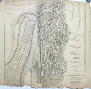
Sold2017Map of the Siege of Vicksburg, MississippiMap: Map of the Siege of Vicksburg, Mississippi Description: This large battle map identifies Union and Confederate entrenchments. It is very detailed, showing the roads, streets, houses, railroads, vSee Sold Price
Sold2022TWO MAPS OF CIVIL WAR INTEREST Late 19th Century Colored lithographs on paper, 17" x 28" sight.TWO MAPS OF CIVIL WAR INTERESTLate 19th Century"Plate XXXII Plan of the Battle on Stone River before Murfreesborough" and "Plate XLVI Map of the Battle-Field of Chickamauga", bothSee Sold Price
Sold20241864 Harper's Weekly Map of U.S. South - Civil WarEngraving depicting a map of the southern United States to illustrate the Civil War. Published by Harper's Weekly on March 12, 1864. Captioned "Map of the Campaign in East Tennessee, Mississippi, GeorSee Sold Price
Sold2020Six Unframed MapsFive Harper's Weekly Civil War maps and a 1971 reprint of a 1759 map of City of New Orleans and rivers, together with floor plans for a six floor building.From the private collection of Roulhac ToledaSee Sold Price
Oct 06Schilb Antiquarian Rare Books1866 1ed Jefferson Davis Prison Life Civil War Slavery Confederate President CSA$140(4 bids)
4 days LeftBlackstone Valley Auctions & Estates LLCCivil War Confederate Printing Jefferson Davis$50(1 bid)
Oct 27Schilb Antiquarian Rare Books1867 Illustrated CIVIL WAR Anecdotes Lincoln Assassination Gettysburg Union$24(2 bids)
1 day LeftWeatherham Estate TreasuresAbraham Lincoln Bronze Bust Sculpture On Marble Base - Signed Original - 10lbs$400
Oct 17Weatherham Estate TreasuresAbraham Lincoln Bronze Bust Sculpture On Marble Base - Signed Original - 10lbs$400
Oct 27Schilb Antiquarian Rare Books1885 General Ulysses S. Grant 1ed Civil War Memoirs Union Illustrated MAPS 2v$78(5 bids)


![[CIVIL WAR] Mississippi River Sketch: The Mississippi Raft. March 1860. Pencil on paper. Titled to lower margin. An endearing sketch of a raft along the Mississippi river. From the vantage of a scrubby shore, a log raft dominates the comp](https://p1.liveauctioneers.com/7226/325455/175168988_1_x.jpg?height=310&quality=70&version=1712370394)


![[CIVIL WAR, GETTYSBURG] Post-War Veteran Medals & Badges (1 of 2)](https://p1.liveauctioneers.com/7226/343781/186766932_1_x.jpg?height=282&quality=70&version=1726333566)

![[LINCOLN] General's Commission Signed by Lincoln (1 of 3)](https://p1.liveauctioneers.com/7226/343679/186654896_1_x.jpg?height=282&quality=70&version=1726945754)
![[CIVIL WAR] Ulysses S. Grant Personal Memoirs 1st. Edition (1 of 4)](https://p1.liveauctioneers.com/7226/343679/186654914_1_x.jpg?height=282&quality=70&version=1726238840)
![[CIVIL WAR] Alexandria Slave Pens, Brady CDV (1 of 2)](https://p1.liveauctioneers.com/7226/343679/186654939_1_x.jpg?height=282&quality=70&version=1726238840)
![[CIVIL WAR] Robert E. Lee Signed Portrait (1 of 1)](https://p1.liveauctioneers.com/7226/343781/186766781_1_x.jpg?height=282&quality=70&version=1726333566)

![[CIVIL WAR] Captured Book Inscribed to Jeff. Davis (1 of 4)](https://p1.liveauctioneers.com/7226/343781/186766693_1_x.jpg?height=282&quality=70&version=1726333566)
![[CIVIL WAR] 1864 Lincoln Illustrated Ticket (1 of 1)](https://p1.liveauctioneers.com/7226/343679/186654893_1_x.jpg?height=282&quality=70&version=1726238840)
![[CIVIL WAR] Letter re: Unwell Slave w/ CSA Stamps (1 of 2)](https://p1.liveauctioneers.com/7226/343679/186654962_1_x.jpg?height=282&quality=70&version=1726238840)


![[LINCOLN] Mourning Card (1 of 2)](https://p1.liveauctioneers.com/7226/343679/186654904_1_x.jpg?height=282&quality=70&version=1726238840)
![[LINCOLN] Rare Engraving (1 of 1)](https://p1.liveauctioneers.com/7226/343679/186654894_1_x.jpg?height=282&quality=70&version=1726238840)
![[LINCOLN] Embossed Mourning Card (1 of 2)](https://p1.liveauctioneers.com/7226/343679/186654905_1_x.jpg?height=282&quality=70&version=1726238840)


![[LINCOLN] Cleveland Ledger Assassination Issue (1 of 2)](https://p1.liveauctioneers.com/7226/343679/186654899_1_x.jpg?height=282&quality=70&version=1726238840)
