Sold2023De Eylanden van Pehou' by VAN KEULEN. Penghu Islands Taiwan. VOC chart 1753 mapTitle: De Eylanden van Pehou' by VAN KEULEN. Penghu Islands Taiwan. VOC chart 1753 map Description: De Eylanden van Pehou' by Johannes van Keulen (1753). Early 18th century Dutch sea chart with old coSee Sold Price
Sold2017Millar: Antique Map Netherlands Belgium Luxenburg, 1768Title/Content of Map: 1768 Millar Map of Netherlands, Belgium, Luxenburg -- A New and Accurate Map of the Seven United Provinces Imcluding the Dutch Netherlands & e. Date Printed: 1768 Cartographer: GSee Sold Price
Sold2019Barclay, James 1809 Antique Map. Netherlands & Belgium"The Seven United Provinces, with The Dutch Possessions in Flanders, Brabant and Limburg" Outline Hand Coloured Copper Engraved Map Published 1809, Leeds for "Barclay's Complete and Universal DictionaSee Sold Price
Sold2022Early Hand Colored Maps Depicting the AmericasOne by Pieter Vander, circa 1707, the Magellan period. This map was used to illustrate the Dutch translations of the travel account of Diego Lopez de Sequeira. The second map, pulled from a book on laSee Sold Price
Sold2018c. 1650 Map: Mar del Zur Hispanis Mare PacificumHistoric Maps c. 1650 Hand-Colored Map "Mar del Zur Hispanis Mare Pacificum" by Joannes Jansson with California as an Island Earliest Pacific Sea Chart of the to Appear in a Dutch Atlas c. 1650, Hand-See Sold Price
Sold2017Dutch East India Co.: Antique Map of the World, 1670Map: Mappe-Monde pour connoitre les progres & les conquestes les plus Remarquables des Provinces-Unies, Ainsy que celles des Compagnies d'Orient et d'Occident Cartographer: Dutch East India Company PlSee Sold Price
Sold2023MAP, Solar System, CellariusCellarius' Striking Chart of the Ptolemaic Cosmography. Solar System. Cellarius/Schenk & Valck, Scenographia Systematis Mundani Ptolemaici, from Atlas Coelestis seu Harmonia Macrocosmica, 1708 (publisSee Sold Price
Sold2024EARLY 18TH C. DUTCH CHART OF PACIFIC OCEAN BY FREDERIK DE WIT (1629-1706) WITH CALIFORNIA AS AN"Magnuum Mare del Zur, cum Insula California, De Groote Zuyd-Zee en't Eylandt California; Gedruck't Amsterdam by Frederick De Wit ince Calver Street". Handcolored copper engraving. Engraver: Romeyn deSee Sold Price
Sold2023A DUTCH MAP OF THE GULF OF MEXICO AND THE CARIBBEAN, "Stoel des Oorlogs in America," CIRCA 1730,A DUTCH MAP OF THE GULF OF MEXICO AND THE CARIBBEAN, "Stoel des Oorlogs in America," CIRCA 1730, copper plate engraving with hand-coloring, published by Reinier and Josua Ottens in Amsterdam; 20" x 22See Sold Price
Sold2022LARGE ARCHITECTS PRINT / MAP / CHART CABINETFantastic very large Architectural draftsman/chart/map/print flat file - George III-Style mahogany with satinwood inlay, inset tooled leather top. 8 Drawer over 4 drawer. from the Audubon Gallery, KinSee Sold Price
Sold2018(1635) Blaeu Map: Mappa Aestivarvm Insularum,...Historic Maps Hand-Colored "Mappa Aestivarvm Insularum, alias Barmvdas dictarum..." by Willem J. Blaeu, Amsterdam (1635) Hand-Colored Historic Dutch Map titled: "Mappa Aestivarvm Insularum, alias BarmSee Sold Price
Sold2017STEAM BOAT PAPER/LETTERHEAD, TRAVEL CHARTS/MAPSBOX LOT ASSORTED STEAM BOAT PAPER/LETTERHEAD, TRAVEL CHARTS/MAPS, BROADSIDE WALTER BRETT, 1869See Sold Price
Sold2024Jodocus Hondius, Dutch, 1563-1612 Map Of Virgina And The SoutheastJodocus Hondius, Dutch, 1563-1612 Map Of Virgina And The Southeast. Hand-Colored engraving on laid paper, title in cartouche to upper left corner "Virginiae / item et / FLORIDAE / Americae ProvinciariSee Sold Price
Sold2022(MEXICO.) Henry Schenk Tanner. A Map of the United States of Mexico,(MEXICO.) Henry Schenk Tanner. A Map of the United States of Mexico, As Organized and Defined by the Several Acts of Congress of that Republic. Large hand-colored lithographed map of southwestern NortSee Sold Price
Sold2017Dutch 'American Septentrionalis' map, circa 1647Johannes Janssonius, known as Jan Jansson (Dutch, 1588-1664), hand colored copper engraving titled 'America Septentrionalis,' executed in Amsterdam circa 1647, depicting a cartographic amalgamation ofSee Sold Price
Sold20201763 Map Of Province Of Quebec, Captain Carver1763 Map Of Province Of Quebec, Captain Carver. A New Map Of The Province Of Quebec, According To The Royal Proclamation, Of The 7th Of October 1763 : From The French Surveys Connected With Those MadeSee Sold Price
Sold20241719 BIBLE in DUTCH ILLUSTRATED w/ MAPS antique MASSIVE FOLIO BIBLIAantbooks1 BIBLIA, DAT IS DE GANTSCHE H. SCHRIFTURE, vervattende alle de canonijcke boecken des ouden en des nieuwen testaments (...). Laft Der Hoogha Mgh Heeren Dordrecht, Pieter Keur; 1719 IllustrateSee Sold Price
Sold20241766 Emanuel Bowen "The Maps And Charts Of The Modern Part Of The Universal History"Printed for T. Osborne, A. Millar, J Rivington, B. Law And Co., T. Longman, C. Ware, and S. BladonSee Sold Price
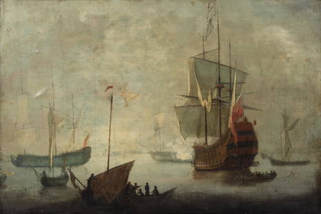
Sold2020Follower of Willem van de Velde II, paintingFollower of Willem van de Velde II, painting, Follower of Willem van de Velde II (Dutch, 1633-1707), Two English Royal Yachts Getting Under Way, oil on canvas, no signature observed, 24.5"h x 29.5"w (See Sold Price
Sold2023Leo Jansen Eve, 1972Leo Jansen (Dutch, American, 1930-1980) Eve, 1972 Oil on canvas 30 x 40 (in) 49.5 x 39.75 x 2.5 (in) Framed Signed Leo Jansen, lower right Titled on frame plaque. Dated 9/1972, verso.See Sold Price
Sold2017Rare - 1768 Holland - Jeffreys Map of New York and NewThe rarest and earliest state of a seminal map. The Provinces of NEW YORK and NEW JERSEY with part of PENSILVANIA, and the Governments of TROIS RIVIERES, and MONTREAL: drawn by Capt. Holland. / A ChorSee Sold Price
Sold2019Circle of Willem Van de Velde the Younger (Dutch,Circle of Willem Van de Velde the Younger (Dutch, 1633-1707) Untitled Naval Scene oil on canvas 24 x 37 1/2 inches. Provenance: Provenance: Private Collection, West Palm Beach, FL Pawsey & Payne, LondSee Sold Price
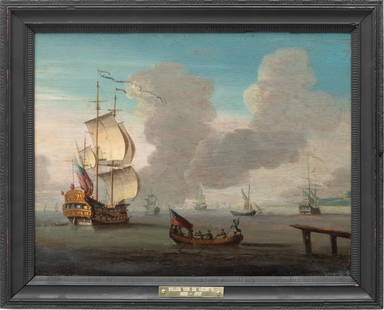
Sold2023In the Manner of Willem Van De Velde the Younger (Dutch, 1633-1707) Oil on Wood Panel, Ca. 1860, "AIn the Manner of Willem Van De Velde the Younger (Dutch, 1633-1707) Oil on Wood Panel, Ca. 1860, "A Ship of War", H 12" W 16" | Depicting a rowboat leaving a pier for a ship of war. Unsigned. Verso haSee Sold Price
Sold2020(CELESTIAL.) Cellarius, Andreas. Typus Aspectuum,(CELESTIAL.) Cellarius, Andreas. Typus Aspectuum, Oppositionum et Coniuntionum Etz in Planetis. Hand-colored double-page engraved celestial chart with a map of the world on a north-polar projection shSee Sold Price
2 days LeftJasper521707 Schenk Dutch Provinces Chart with Leo Belgicus Map -- Tafel vande XVII Nederlandze Provincien,$240
2 days LeftJasper521700 Schenk Map of Russian Empire -- La Russie Blanche ou Moscovie Divisee Suivant l'Estendue des$240
2 days LeftJasper52Alhambra Palace - Antique steel engraving - Pieter Van der Aa (Alvarez de Comenar). 1707.$65
2 days LeftJasper52Chevaliers from Portugal - Antique steel engraving - Pieter Van der Aa (Alvarez de Comenar). 1715.$70
2 days LeftJasper521715 Schenk Map of Western Czechia Around Karlovy Vary -- Geographischer Entwurff der Stadt und$220
2 days LeftJasper521877 Adams Chart of Human History -- Adams' Syn Chronical Chart or Map of History$400
3 days LeftJasper52South Pacific Ocean. French Polynesia Cook Islands. US Navy sea chart 1895 map$130
3 days LeftJasper52Nouvelle Caledonie. Baies de Kuakue et de Uinne'. CHAMBEYRON sea chart 1891 map$100
Featured3 days LeftJasper52NW Coast of America & NE Coast of Asia… ROBERTS / DELAROCHETTE. Pacific 1794 map$700
3 days LeftJasper52Pacific Ocean sea chart. Ports lighthouses mail routes dockyards LARGE 1952 map$30
3 days LeftJasper52Pacific Ocean sea chart. Ports lighthouses mail routes dockyards LARGE 1959 map$35
3 days LeftJasper52Pacific Ocean sea chart. Ports lighthouses mail routes dockyards LARGE 1927 map$35
3 days LeftJasper52Hawaiian–Emperor seamount chain Midway-Kauai ADMIRALTY chart 1950 (1955) map$140