Sold2024Rare Antique Map - Hudson Bay Chart - Old Map of North America - Bellin - Jacques"Carte de la Baye de Hudson". Its finely engraved, hand-coloring engraved map from the Dutch edition of acques Nicolas Bellin Histoire "General of Travel". Published in Amsterdam. A handsome chart ofSee Sold Price
Sold20231754 ART of WAR 2 VOLUMES ILLUSTRATED w/ 25 MAPS antique L'ART DE LA GUERREESSAI SUR L'ART DE LA GUERRE. by TURPIN de CRISSE, Lancelot 2 volumes Paris; 1754 4to: 9 by 11.5" [10]-443-[1], [4]-4-204-[2] pp.; 25 folding plates - Rare 1st ed. of Turpin de Crissé's treatiseSee Sold Price
Sold2021Map of Guiana PLANO GENERAL DE LA PROUINCIA DE LA ProuiRare Antique Map of Guiana PLANO GENERAL DE LA PROUINCIA DE GUAIANA by Manuel Centurión 1770 | Inscribed with page or plate number 4 | Professionally matted | Approx. Size: 19\" W x 15.5\" H.See Sold Price
Sold2022AN ANTIQUE PRINTED MAP BY N. BELLIN / J. VAN SCHLEY, Paris / Amsterdam c.1770. CARTE DE LA BAYEAN ANTIQUE PRINTED MAP BY N. BELLIN / J. VAN SCHLEY, Paris / Amsterdam c.1770. CARTE DE LA BAYE DEHISCE ...; Copperplate coloured. This chart for a Dutch edition of Prevost's 'Histoire des Voyages' fiSee Sold Price
Sold2021Antique mapAntique Dutch hand-colored map. La Seigneurie. D. Over-ijssel. By H. Jaillot, Paris. 1692. 17th Century. Small damage. Dimensions: H 58 x W 46 cm. In fair/good condition.See Sold Price
Sold20231799 United States MAP 1ed Rochefoucauld Voyages in Canada INDIANS Saratoga1799 United States MAP 1ed Rochefoucauld Voyages in Canada INDIANS Saratoga La Rochefoucauld-Liancourts account of his voyage to the New World is an important perspective on America and Canada prior tSee Sold Price
Sold20241598 COSMOGRAPHY by Sebastian Munster antique RARE ILLUSTRATED w/ MAPS PIGSKINMUNSTER, Sebastian (1489-1552). Cosmographey, das ist, Beschreibung aller Länder, Herrschafften und fürnemesten Stetten des gantzen Erdbodens Cosmography: that is, description of all countries... BaSee Sold Price
Sold2019Ca.1798 Antique Maps by La Perouse (6)Circa 1798 six antique maps by La Perouse. Published by G. G. and J. Robinson, Paternoster Row. On rag paper. Measure 17 in. x 11 in and 11 in. x 17 in. Unframed, loose and not mounted or glued down.See Sold Price
Sold20241719 BIBLE in DUTCH ILLUSTRATED w/ MAPS antique MASSIVE FOLIO BIBLIAantbooks1 BIBLIA, DAT IS DE GANTSCHE H. SCHRIFTURE, vervattende alle de canonijcke boecken des ouden en des nieuwen testaments (...). Laft Der Hoogha Mgh Heeren Dordrecht, Pieter Keur; 1719 IllustrateSee Sold Price
Sold20231788 VOYAGE TO AMERICA by F. CHASTELLUX antique ILLUSTRATED w / MAPS 2 VOLUMESVOYAGES DANS L'AMÉRIQUE SEPTENTRIONALE, DANS LES ANNÉES 1780, 1781 & 1782 2 volumes by CHASTELLUX, François-Jean de Paris; 1788-1791 8vo: 5 1/4 by 8 1/4" [8]-408, [4]-251 pp. Second autSee Sold Price
Sold20222 SETS OF 2 - LA PEROUSE VOYAGE RELATED BOOKSVOYAGE OF LA PEROUS PUBLISHED IN 1798. VOYAGE IN SEARCH OF LA PEROUSE PUBLISHED IN 1800. THEY COME WITH PULL OUT MAPS.See Sold Price
Sold20241582 FIGURES DE LA BIBLE antique ILLUSTRATED w/ 430 WOODCUTS RARE 16th CENTURYChappuys, Gabriel: Figures de la Bible declares par stances, par G. C. T. Augmantees de grand Nombre de figures aux Actes des Apostres. Lyon, Barthelemy Honorat, 1582 3 parts in 1 volume. 108; 44; 84See Sold Price
Sold20201798 Monterey California North America MapTitle: Plan de la Baie de Monterey" - Monterey California North America map Karte Amerika Atlas du Voyage de la Perouse. Published: by G.G. & J. Robinson, Pater-noster Row. Size: Artwork: 10 x 15 1/2See Sold Price
Sold2023ANTIQUE c.1850 MAP of LOUISIANA w LAND DISTRICT s by W R BOYD SURVEYOR GEN'L, LAANTIQUE c.1850 MAP of LOUISIANA w LAND DISTRICT s by W R BOYD SURVEYOR GEN'L, LA ANTIQUE c.1850 MAP of LOUISIANA w LAND DISTRICT s by W R BOYD SURVEYOR GEN'L, LA Description Antique 1850 Map of LouisiSee Sold Price
Sold2018Bellin / la Harpe: Antique Map of the World, 1740Title/Content of Map: Rare large world Map Date Printed: 1740-1770's Cartographer: J.N. Bellin & J.F. La Harpe Material/Medium: Paper Size: 21 1/4" x 28" Copperplate engraved. From the 'Abrege de L'HiSee Sold Price
Sold20231671 HISTOIRE GENERALE DES VOYAGES ET CONQUESTES antique RARE1671 HISTOIRE GENERALE DES VOYAGES ET CONQUESTES des Castillans dans les Isles et Terre-ferme des Indes Occidentales by HERRERA, Antonio de Paris: Nicolas de La Coste; 1671 First edition. The first SpSee Sold Price
Sold20231742 HISTORY of JEWS 6 VOLUMES ILLUSTRATED w/ MAPS antique in FRENCH JUDAICAJudaica Prideaux (Humphrey) Histoire Des Juifs Et Des Peuples Voisins Depuis La Décadence Des Royaumes D'Israel & De Juda 6 volumes Paris, Guillaume Cavelier, père, 1742. Titles in red and blackSee Sold Price
Sold2021Pair of 18th c. LA PÉROUSE Map Engravings -Plates 51&52Pair of the Original 18th c. LA PÉROUSE copperplate engraved maps - Plates 51 & 52 - from The Voyage of La Pérouse Round the World in the Years 1785, 1786, 1787, and 1788 | Published as the Act DireSee Sold Price
Sold20221664 BIBLE DUTCH BIBLIA MASSIVE FOLIO w/ CLASPS & MAP antique 11 x 17"Paulus Aertsz. van Ravensteyn / Nicolaes Visscher BIBLIA; dat is: de gantsche H. Schrifture, vervattende alle de canonijcke boecken des Ouden en des Nieuwen Testaments. [ ... ] door last der Hoogh.-moSee Sold Price
Sold2021(TRAVEL -- PACIFIC.)(TRAVEL -- PACIFIC.) The Voyage of La Perouse Round the World in the Years 1785...1788. Arranged by M.L.A. Milet Mureau. 2 volumes. 48 (of 51 engraved plates and maps). London: John Stockdale, 1798.[aSee Sold Price
Sold2024De Jode, pub. 1593 - Map of Gelderland, Netherlands, Dutch Province (Geldria?)This truly significant map is from one of the rarest atlases ever published, Gerard and Cornelis de Jode's Speculum orbis Terrae. The work was published in Antwerp in 1593 by Arnold Coninx for the widSee Sold Price
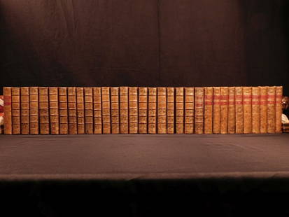
Sold20181780 1ed RARE Complete VOYAGES Maps Captain Cook Americ1780 1ed RARE Complete VOYAGES Maps Captain Cook America Explorers Africa 32v The best book of its kind! An extremely rare, 32-volume complete set of La Harpe’s ‘General History of Voyages’! ThiSee Sold Price
Sold20181780 1ed RARE Complete VOYAGES Maps Captain Cook1780 1ed RARE Complete VOYAGES Maps Captain Cook America Explorers Africa 32v The best book of its kind! An extremely rare, 32-volume complete set of La Harpe’s ‘General History of Voyages’! ThiSee Sold Price
Sold2023La Mappe Monde- Map of 3 Voyages of Captain CookAntique Map Print- La Mappe Monde, Depicting the Three Voyages of Captain Cook. Original was Drawn by Herisson, Hand Watercolored, Number 64 and Dated 1816. Measures 33 1/2" x 47" framed. Good ConditiSee Sold Price
1 day LeftJasper521816 VOYAGE TO ABYSSINIA by HENRY SALT w/ MAP antique 1st AMERICAN EDITION rare$400
1 day LeftJasper521792 ANCIENT HISTORY of INDIA antique ILLUSTRATED w/ MAPS 18th CENTURY in FRENCH$170
5 days LeftTrillium Antique Prints & Rare BooksVaillant - 4 Views of South America: Peru, Bolivia, Chili$75
2 days LeftJasper52Isles de la Société. Society Islands. Huaheine Raiatea Polynesia. BONNE 1788 map$35
2 days LeftJasper52Isles de la Reine Charlotte. Nendo, Santa Cruz, Solomon Islands. BONNE 1790 map$20
2 days LeftJasper52Isles de la Reine Charlotte. Nendo, Santa Cruz, Solomon Islands. BONNE 1788 map$20
2 days LeftJasper52Entrée de Norton & Détroit de Bhering. Bering Strait Norton Sound BONNE 1790 map$30(1 bid)
Featured2 days LeftJasper52Entrée de Norton & Détroit de Bhering. Bering Strait Norton Sound BONNE 1788 map$30
1 day LeftJasper521723 Dampier Map of Voyages to Brazil, Australia and Eat Indies -- Voyage du Cap. Dampier a la N.$280
Featured1 day LeftJasper521719 BIBLE DUTCH BIBLIA FOLIO w/ CLASPS & MAPS antique decorative binding$800
1 day LeftJasper52Embarkation of the Princess of Portugal, Catherine, wife of Charles II, the King of England- Antique$70
Featured2 days LeftJasper52Micronesia. Tinian coast profiles, Northern Mariana Islands. Anson's voyage 1761$25


![1754 ART of WAR 2 VOLUMES ILLUSTRATED w/ 25 MAPS antique L'ART DE LA GUERRE: ESSAI SUR L'ART DE LA GUERRE. by TURPIN de CRISSE, Lancelot 2 volumes Paris; 1754 4to: 9 by 11.5" [10]-443-[1], [4]-4-204-[2] pp.; 25 folding plates - Rare 1st ed. of Turpin de Crissé's treatise](https://p1.liveauctioneers.com/5584/276533/145377010_1_x.jpg?height=310&quality=70&version=1675202312)


![1788 VOYAGE TO AMERICA by F. CHASTELLUX antique ILLUSTRATED w / MAPS 2 VOLUMES: VOYAGES DANS L'AMÉRIQUE SEPTENTRIONALE, DANS LES ANNÉES 1780, 1781 & 1782 2 volumes by CHASTELLUX, François-Jean de Paris; 1788-1791 8vo: 5 1/4 by 8 1/4" [8]-408, [4]-251 pp. Second aut](https://p1.liveauctioneers.com/5584/304737/162633733_1_x.jpg?height=310&quality=70&version=1696971416)


![1664 BIBLE DUTCH BIBLIA MASSIVE FOLIO w/ CLASPS & MAP antique 11 x 17": Paulus Aertsz. van Ravensteyn / Nicolaes Visscher BIBLIA; dat is: de gantsche H. Schrifture, vervattende alle de canonijcke boecken des Ouden en des Nieuwen Testaments. [ ... ] door last der Hoogh.-mo](https://p1.liveauctioneers.com/5584/248552/129022225_1_x.jpg?height=310&quality=70&version=1653430568)