Sold2023Framed Map of the Ottoman Empire, 1696Print of 17th century map, originally engraved by Alexis-Hubert Jaillot (1632-1712, France), depicting the Ottoman Empire circa 1696 Provenance: a San Antonio, Texas collection We happily provide seSee Sold Price
Sold202117th c. Antique H/C Map of Ottoman / Turkish EmpireMap - Accuratissima et maxima totius Turcici Imperii tabula cum omnibus suis regionibus novissima delineatio | Title: Accuratissima et maxima totius Turcici Imperii tabula cum omnibus suis regionibusSee Sold Price
Sold2023ANTIQUE 18TH C HAND COLORED MAP OF OTTOMAN EMPIREAn antique early 18th-century hand-colored engraved map representing the Ottoman Empire. Published in Nuremberg, Germany, 1720. Titled Imperium Turcicum, technical information in Latin in the lower leSee Sold Price
Sold2022Balkans.- Pouqueville (F. C. H. L.) Travels through the Morea, Albania, and several other parts ofBalkans.- Pouqueville (F. C. H. L.) Travels through the Morea, Albania, and several other parts of the Ottoman Empire, to Constantinople, folding engraved map, folding table, 2 aquatints, 1 folding, sSee Sold Price
Sold2023Heavy Horseman's Axe, Ottoman Empire 16-17th C.Heavy horseman's axe with gold inlaid faces engraved with scrolling and calligraphic script, blunt rear hammer style head, engraved to the shaft mount with avian scene. Circa 16th to 17th century OttoSee Sold Price
Sold202117th Century Engraved Map Galliae Veteris Typus 1661Fine 17th Century Engraved Map Galliae Veteris Gaul France by Pieter van den (Peter) Keere (Kaerius), 1661 | Galliae Veteris [Of the Old Gaul], Depicting Gaul, France, British Channel, Belgium, FlandeSee Sold Price
Sold2022Map: A 17thC engraved map of Oxford after Johannes Blaeu titled Oxonium Comitatus Vulgo Oxfordshire.Map: A 17thC engraved map of Oxford after Johannes Blaeu titled Oxonium Comitatus Vulgo Oxfordshire. With decorative hand coloured cartouches, mileage scale, the vertical margins with sixteen heraldicSee Sold Price
Sold2021Framed 17th C. German Engraved Map of France**First Time At Auction** Europe, German, 17th century. "Das Konigreich Franckreich" (The Kingdom of France) Nova Gallia Tabula - copper plate engraving, ca. 1630. A finely engraved map of the KingdomSee Sold Price
Sold2016*ANTIQUARIAN 17TH C. HANDCOLORED ENGRAVED MAPAmerica's northeast state coast line with Massachusetts, New York and possibly Virginia, as well as unexplored provinces of Canada including Quebec, approximate plate size 15" x 20", frame 21 1/2" x 2See Sold Price
Sold2019Pieter van den Keere, map of DaciaPieter van den Keere, Dacia and Moesia, 17th century hand coloured engraved map, possibly by Jansson, 37 x 48cmSee Sold Price
Sold2022(TRANSYLVANIA.) Two 17th-century hand-colored engraved maps of central Romania.(TRANSYLVANIA.) Two 17th-century hand-colored engraved maps of central Romania. Amsterdam, 1630s - Mercator/Hondius. Transylvania. 18x21¼ inches sheet size, wide margins, German text on verso; liSee Sold Price
Sold2022A. Mallet & G. Ruscelli MapsThree 16th and 17th century hand-colored engraved maps. Includes one titled "Cercle de Bourgogne" (Circle of Burgundy) and another titled "France par Governmens Generaux" (France by General GovernmentSee Sold Price
Sold2023Map of Nova ZemlaAntique Map of Nova Zemla , 17th c., hand-colored engraved map, by Johannes Janssonius, Amsterdam, cartouches show hunters, walruses, arctic foxes, and polar bears, neat lines 16 in. x 20 in., laid doSee Sold Price
Sold2022Sword, probably Ottoman Empire, 17tSword, probably Ottoman Empire, 17th century, slightly balanced blade with engraving: portrait profile, sun-moon stars together with symbolic writing, on the other side depiction of an Ottoman and insSee Sold Price
Sold2021Early Hand-Colored Map of VeniceItaly, ca. 16th-17th century. Fine hand-colored engraved map of "Venetia" with boats in harbor and compass rose. Handsomely framed. MEASUREMENTS Sight wide: 5 7/8 / 15 cm. Sight height: 4 1/2 / 11.5 cSee Sold Price
Sold2023Unknown (19th), Battle of the Dardanelles 1656, PencilUnknown (19th century): Depiction of the Battle of the Dardanelles in 1556, naval battle between the Republic of Venice and the Ottoman Empire, 17th century, Pencil Technique: Pencil on Paper InscriptSee Sold Price
Sold202217th C Abraham Ortelius Map of Turkish Empire17th C Abraham Ortelius (Flemish, 1527-1598) Map of Turkish Empire from Theatrum Orbis Terrarum (Published London, 1606). Titled Representation of the Turkish Empire by Abraham Ortelius. Some loss toSee Sold Price
Sold2016Seutter, Hand Colored Map, Ottoman Empire, 18th C.German, circa 18th century. "Magni Turcarum Dominatoris Imperium per Europam, Asiam, et Africam se extendens Regiones tam proprias quam tributarias et clientelares ut et omnes Beglerbegatus sive PraefSee Sold Price
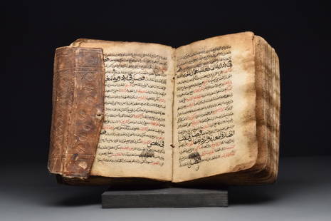
Sold2022MEDICAL MANUSCRIPT INCLUDING TREATMENTS FOR SCABIESOttoman Empire, Ca. 17th century AD An Arabic Medical text, it includes treatments for scabies and improvements for sexual performance. In a beautiful, tooled leather container with roundel motifs.SizSee Sold Price
Sold202217th/18th c. Ottoman Gilt Copper Tombak Incense BurnerGilt copper 17th or 18th c. Turkish or Ottoman Empire tombak incense burner with openwork and incised decoration depicting floral motifs. With a hinged lid. Attached to a circular tray.Provenance: FroSee Sold Price
Sold2023Antique Map of HispaniolaAntique Map of Hispaniola, "Hispaniolae, Cubae...", Ortelius, late 17th/early 18th c., hand-colored engraved map, sight 15 in. x 21 1/2 in., framedSee Sold Price
Sold2017Framed Colored Engraved 17th C. World Map"Nova Totius Terrarum Sive Novi Orbis Tabula" Framed Colored Engraved 17th C. World Map by Willem Janszoon Blaeu - This interesting piece is an early world map created by Willem Janszoon Blaeu. The maSee Sold Price
Sold2023A SILVER MEGILLAH CASE WITH ORIGINAL MEGILLAHA SILVER MEGILLAH CASE WITH ORIGINAL MEGILLAH. Ottoman Empire, c. 1880. Engraved and chased with flowers, scrolling designs, and other organic designs. Topped with a bird. Fitted with the original megSee Sold Price
Sold2020Rare 17th C Map of Russia17th C Map of Russia, engraved, text on verso. Fine, measures 7.5 x 5". Reserve: $50.00 Shipping: Domestic: Flat-rate of $5.00 to anywhere within the contiguous U.S. International: Foreign shipping raSee Sold Price
May 09Hunt and Peck Estate Services, Inc.1696 Jaillot Mapping The Ottoman Empire at the End of the 17th Century$140
Bonhams[OCCULT SCIENCE] 'THE MAGICAL CALENDAR OF TYCHO BRAHE': RARE HERMETIC BROADSIDE. GROSSCHEDEL, JO...$22,000
May 19NY Elizabeth A PAIR OF 15TH / 17TH CENTURY OTTOMAN / MAMLUK GEOMETRIC MARBLE MOSAIC WALL PANELS, EGYPT$1,000
May 19NY Elizabeth A 15TH / 17TH CENTURY OTTOMAN / MAMLUK GEOMETRIC MARBLE MOSAIC WALL PANEL, EGYPT PROBABLY CAIRO$100(1 bid)
May 19NY Elizabeth A 15TH / 17TH CENTURY OTTOMAN / MAMLUK POLYCHROME GEOMETRIC MARBLE MOSAIC WALL PANEL, EGYPT$100
May 19NY Elizabeth A 15TH / 17TH CENTURY OTTOMAN / MAMLUK GEOMETRIC MARBLE MOSAIC WALL PANEL, EGYPT$100
May 19NY Elizabeth A 15TH / 17TH CENTURY OTTOMAN / MAMLUK POLYCHROME GEOMETRIC MARBLE MOSAIC WALL PANEL, EGYPT$100
May 19NY Elizabeth A PAIR OF 15TH / 17TH CENTURY OTTOMAN / MAMLUK GEOMETRIC MARBLE MOSAIC WALL PANELS, EGYPT$1,000
May 19NY Elizabeth A PAIR OF 15TH / 17TH CENTURY OTTOMAN / MAMLUK GEOMETRIC MARBLE MOSAIC WALL PANELS, EGYPT$1,000
May 19NY Elizabeth A 15TH / 17TH CENTURY OTTOMAN / MAMLUK GEOMETRIC MARBLE MOSAIC WALL PANEL, EGYPT$100
6 days LeftTremont Auctions17th century original map 1676 "Virginia and Maryland" by John Speed. 2 sided framing. Overall:$325(2 bids)
Jun 02Nazmiyal Auctions17th Century Antique Ottoman Embroidery Textile 6 ft 1 in x 3 ft 7 in (1.85 m x 1.09 m)$2,000
6 days LeftTremont Auctions17th century original map of Magellan Straights by Mercator and Hondius. 2 sided framing. Overall:$150


![17th Century Engraved Map Galliae Veteris Typus 1661: Fine 17th Century Engraved Map Galliae Veteris Gaul France by Pieter van den (Peter) Keere (Kaerius), 1661 | Galliae Veteris [Of the Old Gaul], Depicting Gaul, France, British Channel, Belgium, Flande](https://p1.liveauctioneers.com/6084/191709/96596842_1_x.jpg?height=310&quality=70&version=1611008674)


![[OCCULT SCIENCE] 'THE MAGICAL CALENDAR OF TYCHO BRAHE': RARE HERMETIC BROADSIDE. GROSSCHEDEL, JO... (1 of 4)](https://p1.liveauctioneers.com/1043/325155/176458568_1_x.jpg?height=282&quality=70&version=1714118631)


