Sold20181871 MAP OF BULLS BAYAntique 1871 Map of the Entrance to Bull and Combahee Rivers, South Carolina. U.S. Coast survey Benjamin Peirce Superintendent entrance to Bull and Combahee rivers South Carolina 1871. This original nSee Sold Price
Sold2021Kent Estate Map, Chevening.- Barham (surveyor) The HomeKent Estate Map, Chevening.- Barham (surveyor) The Home Farm In Chevening Kent Belonging to The Ri.t Hon.ble Lord Amherst, manuscript watercolour estate map on vellum, fold, 475 x 500mm., 1797; and anSee Sold Price
Sold2022Real estate map for south part of San Francisco 1868Heading: -1868 Author: Kower, Emile Title: Map of the Golden Gate Homestead Association Place Published: San Francisco Publisher:Britton & Rey's Lithographic Steam Press Date Published: 1868<See Sold Price
Sold2022KENT – LYDD – MANUSCRIPT ESTATE MAP 'A Map of a Farm lying in the Parish of Lydd in ...KENT – MANUSCRIPT ESTATE PLAN 'A Map of a Farm lying in the Parish of Lydd in the County of Kent Belonging to the Reverd. Mr Richard Monins 1774.', manuscript map by Henry Maxted & Isaac Terry,See Sold Price
Sold2020Real estate map of Berkeley Woods with ms. noted, 1917Heading: (California - Contra Costa County) Author: Title: Map of Berkeley Woods Contra Costa County, Cal. Scale 1 in. = 100 feet Place Published: [Berkeley, CA] Publisher: Date Published:See Sold Price
Sold2020Pocket real estate map of Bellingham WA 1910Heading: (Washington - Bellingham) Author: Title: Map of Bellingham north, Washington Place Published: Bellingham, Wash. Publisher:Bellingham Bay Improvement Co Date Published: 1910 DeSee Sold Price
Sold2022Sutro Heights real estate map c.1895Heading: -1895 Author: Title: Map of Sutro Heights. Lots for Sale by Will E. Fisher & Co., Agents Place Published: San Francisco Publisher: Date Published: c.1895 Description: LSee Sold Price
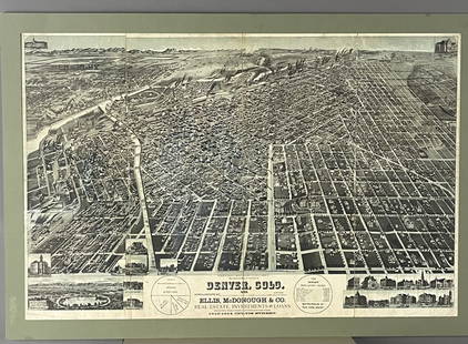
Sold2019Rockland county, NY Ariel maps Real Estate map rareRockland county, NY Ariel maps Real Estate map rareSee Sold Price
Sold20211871 Map of Austria and HungaryAuthor: Bartholomew Title: 1871 Map of Austria and Hungary Medium: Ink on Paper Dimensions: 13"X10.5" Map of Austria and Hungary dated 1871. Engraved for John Bartholomew and co. Published in EdinburgSee Sold Price
Sold2024Gano Estate Map, Spring Grove, Avondale & Cincinnati RailwayAmerica, 19th century. A map and letter dating to 1881 on the topic of the Gano Estate pertaining to the Spring Grove, Avondale & Cincinnati Railway. 428See Sold Price
Sold2022France.- Manuscript estate maps.- Marche (Lecoy de la) [Survey of the estates of Château-France.- Manuscript estate maps.- Marche (Lecoy de la) [Survey of the estates of Château-Renault], manuscript, double-page preface and 2 tables, 9 double-page hand-coloured maps (numbered 2-10, aSee Sold Price
Sold20212 Early Estate Maps2 early estate maps. Hand colored all over with frame. 17" wide, 23" tall.See Sold Price
Sold2015(2pc) [INSURANCE MAPS OF GREENWICH, CONN.]published by Sanborn Map Company, 1920; plus a Greenwich real estate map, 25 3/4 x 23 1/2"See Sold Price
Sold20231871 Framed Map of St. Albans, VT1871 map and directory of Saint Albans, Vermont. Map shows roads, businesses, land ownership, natural features. Some yellowing, water damage present. Framed, 31"x37"See Sold Price
Sold20201871 Colton Map of Missouri -- Colton's Dollar SeriesTitle/Content of Map: 1871 Colton Map of Missouri -- Colton's Dollar Series of Sectional Maps. Missouri Cartographer: GW & CB Colton Year/Place: 1871, New York Size: 26.9 X 29.9 in. This is a superb fSee Sold Price
Sold2017Hardy: Antique New York City Fire Department Map, 1871Title: 1871 Hardy New York City Fire Department Map -- Map of the Boundaries of the Fire Department of the City of New York Made Under the Direction of the Fire Commissioners Cartographer: J Hardy YeaSee Sold Price
Sold20181871 Mitchell Map of Texas -- XIII TexasTitle/Content of Map: 1871 Mitchell Map of Texas -- XIII Texas Date Printed: 1871, Philadelphia Cartographer: S Mitchell / Butler Co. Size: 8.3 x 10.5 in. This is very nice map of Texas, part of a schSee Sold Price
Sold20201871 Hardy Map on New York City Police Districts andTitle/Content of Map: 1871 Hardy Map on New York City Police Districts and Precincts -- Map of the County of New York Showing the Wards and Police Precincts and Location of Station Houses CartographerSee Sold Price
Sold20181871 Mitchell Map of Dakotas, Nebraska, Kansas,Title/Content of Map: 1871 Mitchell Map of Dakotas, Nebraska, Kansas, Colorado and Wyoming -- County Map of Dakota, Wyoming, Kansas, Nebraska and Colorado Date: 1871, Philadelphia Cartographer: S MitcSee Sold Price
Sold20231871 Mitchell's Map of Kentucky and Tennessee -- County Map of Kentucky and TennesseeTitle: 1871 Mitchell's Map of Kentucky and Tennessee -- County Map of Kentucky and Tennessee Cartographer: S Mitchell Year / Place: 1871, Philadelphia Map Dimension (in.): 10.5 X 13.5 This is a ratherSee Sold Price
Sold20221871 Hayden Map of Yellowstone LakeYellowstone Lake Wyoming Territory / Surveyed by the Party in charge of F.V. Hayden U.S. Geologist 1871. Good condition; small tear right side (cellophane tape to the reverse), normal age toning, smalSee Sold Price
Sold2017Antique Real Estate Zone Map of Chicago, 1910Title/Content of Map: 1910 c. Real Estate Zone Map of Chicago -- Zone Map of Chicago Date Printed: 1910 c., Chicago Cartographer: Cook Co. Real estate Digest Size: 16.3 X 10.8 in. An interesting realSee Sold Price
Sold2017Mitchell Map of the Dakotas, Wyoming, etc, 1871Title: 1871 Mitchell Map of the Dakotas, Wyoming, Colorado, Nebraska and Kansas Cartographer: S Mitchell Published: 1871, Philadelphia Measurements: 19.8 X 14.8 in. County Map of Dakota, Wyoming, KansSee Sold Price
5 days LeftTreasure Quest AuctionsPr. Child's Ulster County, NY 1871-72 Gazetteer & Business Directories$50
179 Lots AwayMark Louis Weseloh Estate LiquidationsSix - 17th c. Maps of Europe, Asia, England, Germany x2, Crete, Greece.8 ¼” x 6 5/8”$300
5 days LeftCharleston Estate Services Ltd.ANTIQUE MIDDLE SPOTTED WOODPECKER HAND COLORED LITHOGRAPH$18(2 bids)
Jun 30GOLDEN SUN AUCTIONS, Inc. (formerly Appraisal & Estate Sale Specialists, Inc.)(7) 1985-87 Worlds of Wonder Teddy Ruxpin Tapes & Outfits$10
172 Lots AwayMark Louis Weseloh Estate Liquidations17th cent. John Speed Map of the Isle of Man. Hand Colored, 22” x 17 ½”,$300(1 bid)
28 Lots AwayMark Louis Weseloh Estate LiquidationsOriginal 16th c. Map of Paris - L’isle de France - Parisiensis Agri de Scrip. 21” x 16&#$300
141 Lots AwayMark Louis Weseloh Estate LiquidationsJodocus Hondius Hand Colored Map. Region of Poitou France, c.1600’s. 22 ½” x 19 $300
2 days LeftWeatherham Estate TreasuresUnited States Map with American Flag 3-D Wall Mount Painting$300


![Real estate map of Berkeley Woods with ms. noted, 1917: Heading: (California - Contra Costa County) Author: Title: Map of Berkeley Woods Contra Costa County, Cal. Scale 1 in. = 100 feet Place Published: [Berkeley, CA] Publisher: Date Published:](https://p1.liveauctioneers.com/642/174090/87617742_1_x.jpg?height=310&quality=70&version=1595023143)


![France.- Manuscript estate maps.- Marche (Lecoy de la) [Survey of the estates of Château-: France.- Manuscript estate maps.- Marche (Lecoy de la) [Survey of the estates of Château-Renault], manuscript, double-page preface and 2 tables, 9 double-page hand-coloured maps (numbered 2-10, a](https://p1.liveauctioneers.com/5458/260724/135800184_1_x.jpg?height=310&quality=70&version=1662479034)

![(2pc) [INSURANCE MAPS OF GREENWICH, CONN.]: published by Sanborn Map Company, 1920; plus a Greenwich real estate map, 25 3/4 x 23 1/2"](https://p1.liveauctioneers.com/522/81470/42273580_1_x.jpg?height=310&quality=70&version=1446235682)


