Sold20231810 Published,Ancient world Roman empire mapOrigin:France Date/Period:19th.c Material:Paper Approximate Size: 9 1/4 x 8'' Additional Information: 1810 Published, in Atlas tables elementaires de geographie ancienne et moderne', Paris, by AugusteSee Sold Price
Sold202319thc Colton Map of Canada East, Lower Canada, New BrunswickOriginal & beautiful first edition example, 19th Century hand colored steel plate engraving atlas map by J. H. Colton on heavy paper. "Canada East or Lower Canada" with an inset of Montreal shows earlSee Sold Price
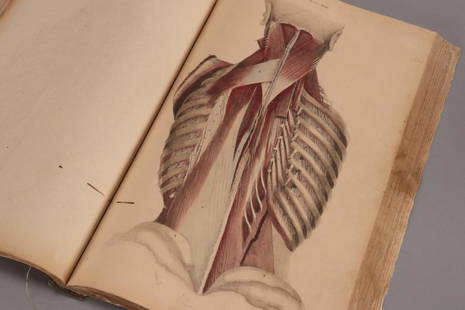
Sold202319th Century Atlas of Anatomia Engraved byWilliam Home Lizars (1788-1859), talented Edinburgh engraver and publisher for Daniel Lizars, for John Lizars Scottish surgeon, anatomist and medical author, comprised of hand coloured engravings on tSee Sold Price
Sold2023America. North/South Americas. California Missions. THOMSON 1830 old mapTITLE/CONTENT OF MAP: 'America' DATE PRINTED: 1830 IMAGE SIZE: Approx 53.0 x 64.0cm, 20.75 x 25.25 inches (Large); Please note that this is a folding map. TYPE: Antique early 19th century atlas map wiSee Sold Price
Sold2022RUSSIAN SILVER SUGAR TONGS AND SUGAR SIFTER SPOONA set of Russian silver sugar tongs and sugar sifter spoon decorated with floral pattern engravings. Hallmarked with the manufacturer and silver proof marks. Circa the late 19th century. Weight: 64 g.See Sold Price
Sold2021(16) 19TH C. MAPS OF THE WEST INDIES IN FOLIO,Including: "L'Isle de Ste. Domingue, et celle de Porto Rico", by Bonne, hand colored engraving,1778, 10" x 14 1/2"; PLUS "West Indies", Smith's Atlas, 1808, hand colored engraving, 1808, 11" x 14"; PLSee Sold Price
Sold2018C.1850 Levasseur Map Amerique SeptentrionaleLevasseur Map with hand-colored engravings from the Atlas National Illustre' (French). Amerique Septentrionale. 19th Century. Measures approximately 14.5" x 20" sheet size. Unframed, loose and not gluSee Sold Price
Sold2023Pierre LAPIE Universal Geography Atlas Ancient and Modern Paris engraving 1812Pierre M. Lapie (1779 - 1850) and his son Alexandre Emile Lapie (1809 - 1850) were French cartographers and engravers active in the early part of the 19th century. The Lapies were commissioned officerSee Sold Price
Sold2023Framed Engravings of Notable Homes and Wall StreetFramed Engravings of Notable Homes and Wall Street, 19th Century,Framed pages from the Atlas of Cuyahoga County Ohio, from Actual Surveys by and under the Directors of D. J. Lake (1874), published bySee Sold Price
Sold2024Map of United States and Mexico. Tardieu and Vuillemin (1863)DescriptionMap of United States and Mexico. Title: États-Units & Méxique Media: engraving on a vellin type paper. Provenance: 'Atlas Universel de Geographie ancienne et moderne', by A. Tardieu and ASee Sold Price
Sold2022Europe Antique MapEurope. Map by Victor Levasseur. From Atlas National Illustree. Paris: mid 19th Century. Engraving, outline color. Pictorial borders. 14 1/4" x 20 1/2".See Sold Price
Sold2015Victor Lavasseur. Map of Haiti or Santo Domingo. 1830.Print of hand colored steel engraving titled Haiti ou Saint Domingue“.Author Victor Lavasseur.Engraved by unknown.From Atlas classique universel de Geographie anciene et moderne“ by Victor LevasseSee Sold Price
Sold2015Victor Lavasseur. Map of North America. 1830.Print of hand colored steel engraving titled Amerique septentrionale“.Author Victor Lavasseur.Engraved by unknown.From Atlas classique universel de Geographie anciene et moderne“ by Victor LevasseSee Sold Price
Sold2015Victor Lavasseur. Map of the world. 1830.Print of hand colored steel engraving titled Mappemonde“.Author Victor Lavasseur.Engraved by unknown.From Atlas classique universel de Geographie anciene et moderne“ by Victor Levasseur. Paris. 18See Sold Price
Sold2015Victor Lavasseur. Map of Colombia and Guyana. 1830.Print of hand colored steel engraving titled Colombie et Guyanes“.Author Victor Lavasseur.Engraved by unknown.From Atlas classique universel de Geographie anciene et moderne“ by Victor Levasseur.See Sold Price
Sold2015Victor Lavasseur. Map of Peru and Bolivia. 1830.Print of hand colored steel engraving titled Perou et Bilivia“.Author Victor Lavasseur.Engraved by unknown.From Atlas classique universel de Geographie anciene et moderne“ by Victor Levasseur. ParSee Sold Price
Sold2016Victor Lavasseur. Map of Asia. 1830.Print of hand colored steel engraving titled „Asie“.Author Victor Lavasseur.Engraved by unknown.From „Atlas classique universel de Geographie anciene et moderne“ by Victor Levasseur. Paris. 18See Sold Price
Sold2015Victor Lavasseur. Map of Africa. 1830.Print of hand colored steel engraving titled Afrique“.Author Victor Lavasseur.Engraved by unknown.From Atlas classique universel de Geographie anciene et moderne“ by Victor Levasseur. Paris. 1830.See Sold Price
Sold2015Victor Lavasseur. Map of Egypt Abyssinia Nubia. 1830.Print of hand colored steel engraving titled Egypte Nubie Abyssinie“.Author Victor Lavasseur.Engraved by unknown.From Atlas classique universel de Geographie anciene et moderne“ by Victor LevasseuSee Sold Price
Sold2015Victor Lavasseur. Map of United States. 1830.Print of hand colored steel engraving titled Etats Unis“.Author Victor Lavasseur.Engraved by unknown.From Atlas classique universel de Geographie anciene et moderne“ by Victor Levasseur. Paris. 18See Sold Price
Sold2015Victor Lavasseur. Map of Persia. 1830.Print of hand colored steel engraving titled Perse Kaboul Herat Beloutchistan“.Author Victor Lavasseur.Engraved by unknown.From Atlas classique universel de Geographie anciene et moderne“ by VictoSee Sold Price
Sold2015Victor Lavasseur. Map of Geography of Hebrews. 1830.Print of hand colored steel engraving titled Geographie des Hebreux“.Author Victor Lavasseur.Engraved by unknown.From Atlas classique universel de Geographie anciene et moderne“ by Victor LevasseuSee Sold Price
Sold2015Victor Lavasseur. Map of Asia. 1830.Print of hand colored steel engraving titled Asie“.Author Victor Lavasseur.Engraved by unknown.From Atlas classique universel de Geographie anciene et moderne“ by Victor Levasseur. Paris. 1830.VicSee Sold Price
Sold202119th C. Karl Bodmer Aquatint Engraving Delaware River**Originally Listed At $800** Karl Bodmer (Swiss-born, 1809-1893). "View on the Delaware, Near Bordentown" (Vignette II from the atlas to the journal of Prince Maximilian of Wied ("Travels in the InteSee Sold Price
Featured1 day LeftJasper52Johnson's Europe. Navigators' routes. Continental Shelf 1861 old antique map$65