Sold20201825 Vandermaelen Map of Puerto Rico -- Amer. Sep.Title: 1825 Vandermaelen Map of Puerto Rico -- Amer. Sep. Porto-Rico. No. 69 Cartographer: P Vandermaelen Year / Place: 1825-7, Paris Map Dimension (in.): 18.8 X 21.1 in. This very interesting largerSee Sold Price
Sold2022Amér. Sep. Partie des États-Unis #55. North Texas Oklahoma VANDERMAELEN 1827 mapTITLE/CONTENT OF MAP: 'Amér. Sep. - Partie des États-Unis - No. 55' The map shows the course of the Red River through North Texas and southern Oklahoma (which at the time of publication wasSee Sold Price
Sold2022Amér Sep Haiti Domingue 68 Hispaniola Turks Caicos Bahamas VANDERMAELEN 1827 mapTITLE/CONTENT OF MAP: Amér. Sep. - Haïti ou St. Domingue [Iles Bahama ou Lucayes] - No. 68 The map shows Hispaniola (today Haiti and the Dominican Republic), Turks & Caicos and part of the BSee Sold Price
Sold2022Amér Sep. Partie des États-Unis #57 Georgia South Carolina VANDERMAELEN 1827 mapTITLE/CONTENT OF MAP: 'Amér. Sep. - Partie des États-Unis - No. 57' The map covers Georgia and South Carolina, with adjacent parts of North Carolina and Florida DATE PRINTED: 1827 IMAGE SIZE: ASee Sold Price
Sold20201825 Vandermaelen Map of the Lesser Antilles -- Amer.Title/Content of Map: 1825 Vandermaelen Map of the Lesser Antilles -- Amer. Sep. Petites Antilles No. 65. Cartographer: P Vandermaelen Year/Place: 1825-7, Paris Size: 18 X 21.1 in. This is a detailed,See Sold Price
Sold2023Venezuela coast. Aruba Bonaire Curacao. ADMIRALTY sea chart 1894 (1955) mapSouth America - North Coast - Tortuga to Cabo la Vela // Catia de la Mar' by From the latest Documents in the Hydrographic Office with additions and corrections from United States and Netherlands GovtSee Sold Price
Sold2018Old map of Venezuela, Janssonius, Amstelodami, circaAntique map of Venezuela, Novae Andalusiae Janssonius, Amstelodami, circa 1650, map shows Venezuela with the Caribbean and Windward Islands, Aruba, Curacao, Bonaire, Los Roques, Isla la Orchila, IslaSee Sold Price
Sold2017Guillaume: Antique Map of Cuba, 1825Map: Ile De Cuba. Publication Date: 1825 Authors: PH. VANDERMAELEN, VANDERMAELEN, PHILIPPE MARIE GUILLAUME (1795-1869) Publisher: PH. VANDERMAELEN Size: Folio – 18.00 H x 21.00 W Inches Amer. Sep. NSee Sold Price
Sold2020Group of MapsGroup of maps, primarily focusing on the Caribbean. Including maps of the Gulf of Mexico, Puerto Rico, the Lesser Antilles, the Barbary Coast, Curacao, and the Islands of Hispaniola and Martinique. SKSee Sold Price
Sold2021MID-CENTURY PUERTO RICO MAP PAINTING ON PANELPainted map of Puerto Rico on wood panel. Supposedly from a 1950s restaurant. Apparently unsigned. Dimensions: H 48.5" x W 96" Condition: Paint losses, wood losses, and surface wear. Black rub line MaSee Sold Price
Sold2022Amér. Mér. Brésil #24. Southern Bahia & NE Minas Gerais. VANDERMAELEN 1827 mapTITLE/CONTENT OF MAP: 'Amérique Méridionale - Partie du Brésil - No. 24' Southern Bahia and north-eastern Minas Gerais DATE PRINTED: 1827 IMAGE SIZE: Approx 51.5 x 60.0cm, 20.25 x 23.75See Sold Price
Sold2022Océanique. Partie de l'ile de Sumatra #18. West Sumatra. VANDERMAELEN 1827 mapTITLE/CONTENT OF MAP: Océanique - Partie de l'ile de Sumatra [Note sur l'île de Sumatra] - No. 18 Western Sumatra, Siberut and the Mentawai Islands, Indonesia DATE PRINTED: 1827 IMAGE SIZE:See Sold Price
Sold2023Amér. Mér. Colombie #8. Ecuador & north-western Peru. VANDERMAELEN 1827 mapTitle: Amér. Mér. Colombie #8. Ecuador & north-western Peru. VANDERMAELEN 1827 map Description: Amérique Méridionale - Partie de la Colombie - No. 8' by Philippe Marie Guillaume VandermaelSee Sold Price
Sold2022Afrique. Partie du Désert de Sahara #6. Canary Islands. VANDERMAELEN 1827 mapTITLE/CONTENT OF MAP: 'Afrique - Partie du Désert de Sahara - No. 6' The eastern Canary islands of Fuerteventura and Lanzarote, part of Western Sahara and southern Morocco DATE PRINTED: 1827 IMAGSee Sold Price
Sold2022Asie. Chine #48 China Heilongjiang. Russia Primorsky Krai. VANDERMAELEN 1827 mapTITLE/CONTENT OF MAP: 'Asie - Partie de la Chine - No. 48' Part of eastern Manchuria/Heilongjiang, the Maritime Territory of Russia, and the Amur River. Shows explorers' routes. DATE PRINTED: 1827 IMASee Sold Price
Sold2024Asie. Turcomanie #40 Caspian Sea. Kazakhstan Uzbekistan. VANDERMAELEN 1827 mapCAPTION PRINTED BELOW PICTURE: 'Asie - Turcomanie - No. 40' The northern Caspian Sea and the northwest Aral Sea with the adjacent part of central Asia in Kazakhstan and Uzbekistan DATE PRINTED: 1827 ISee Sold Price
Sold2024Asie. Tartarie #42 South Kazakhstan. North Kyrgyzstan. VANDERMAELEN 1827 mapCAPTION PRINTED BELOW PICTURE: 'Asie - Partie de la Tartarie - No. 42' Southern Kazakhstan and northern Kyrgyzstan, with the western part of Lake Balkash DATE PRINTED: 1827 IMAGE SIZE: Approx 51.0 x 5See Sold Price
Sold2024Puerto Rico Antique Maps (3)Group of 3 antique folding map sea charts. One of Puerto Rico. Another of San Juan Harbor. The third a composite including Mayaguez Bay. Washington, D.C.: 1899. All fold as issued.See Sold Price
Sold2019MAP - Puerto Rico. PorcacchiPuerto Rico. Tomaso Porcacchi, S. Giovanni, 1713 (published). Black & White. This captivating map of the island of Puerto Rico is based on the cartography of Giacomo Gastaldi. S. Croce (St. Croix) andSee Sold Price
Sold2023L’Isle de St Domingue et… Porto-Rico. Hispaniola & Puerto Rico. BONNE 1790 mapL’Isle de St Domingue et celle de Porto-Rico [The islands of Hispaniola and Puerto Rico] by Rigobert Bonne (1790). Antique 18th century copperplate map, 24.5 x 36.0cm, 9.5 x 14.25 inches; PleaseSee Sold Price
Sold2019Puerto Rico ( labeled San Giovanni).Title/Content of Map: Puerto Rico ( labeled San Giovanni). Date 1576-1590. Cartographer: Porchelli. Size: 8x12”. Provenance: Republic of Venice Using a mostly forgotten name, the island is decoratedSee Sold Price
Sold2017Thomson: Antique Map of Puerto Rico/Hispaniola, 1815Map: Puerto Rico and Virgin Isles/Haiti, Hispaniola, or St. Domingo Cartographer: Thomson Place & Date: Edinburgh / 1815 Size: 24" x 20 1/8" Condition: outline color; overall age toning and some overpSee Sold Price
2017Thomson: Antique Map of Puerto Rico & Virgin IslandsTitle/Content of Map: 'Porto Rico and Virgin Isles. Haiti, Hispaniola or St. Domingo' Date Printed: 1817 Image Size: Approx 54.0 x 65.0cm, 21.25 x 25.5 inches (Large); Please note that this is a foldiSee Sold Price
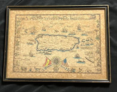
Sold2023Vintage Hand -Colored Pictorial Map of Puerto Rico Circa 1931 by E.B.K. DooleyA vintage hand-colored map of Puerto Rico by E.B.K. Dooley, published c. 1931. This map has a decorative border filled with local plants, wildlife, buildings and transportation. In small scrolls, therSee Sold Price
145 Lots AwayMynt AuctionsPattern Unknown by Frank Whiting Sterling Napkin Ring 1 1/2" wide 2" diameter$10(1 bid)
Jun 23Schilb Antiquarian Rare BooksUS War w/ SPAIN 1898 1ed Puerto Rico CUBA Philippines MAPS Russell Illustrated$185(4 bids)
2 days LeftMynt AuctionsLabors of Cupid by Dominick and Haff Sterling Silver Junior Fork Old 6 1/4"$10(1 bid)
846 Lots AwayMynt AuctionsFrench Renaissance by Reed and Barton Sterling Silver Lasagna Server HHWS Custom$10


![Amér Sep Haiti Domingue 68 Hispaniola Turks Caicos Bahamas VANDERMAELEN 1827 map: TITLE/CONTENT OF MAP: Amér. Sep. - Haïti ou St. Domingue [Iles Bahama ou Lucayes] - No. 68 The map shows Hispaniola (today Haiti and the Dominican Republic), Turks & Caicos and part of the B](https://p1.liveauctioneers.com/5584/271521/142285193_1_x.jpg?height=310&quality=70&version=1670968215)


![Océanique. Partie de l'ile de Sumatra #18. West Sumatra. VANDERMAELEN 1827 map: TITLE/CONTENT OF MAP: Océanique - Partie de l'ile de Sumatra [Note sur l'île de Sumatra] - No. 18 Western Sumatra, Siberut and the Mentawai Islands, Indonesia DATE PRINTED: 1827 IMAGE SIZE:](https://p1.liveauctioneers.com/5584/264830/138097484_1_x.jpg?height=310&quality=70&version=1666125289)


![L’Isle de St Domingue et… Porto-Rico. Hispaniola & Puerto Rico. BONNE 1790 map: L’Isle de St Domingue et celle de Porto-Rico [The islands of Hispaniola and Puerto Rico] by Rigobert Bonne (1790). Antique 18th century copperplate map, 24.5 x 36.0cm, 9.5 x 14.25 inches; Please](https://p1.liveauctioneers.com/5584/305600/163297718_1_x.jpg?height=310&quality=70&version=1697577828)