Sold2017(MAP, SICILY) DE WIT, FREDERICK. Insula sive regnumMAP, SICILY by DE WIT, FREDERICK, Insula sive regnum Siciliae urbibus praecipuis exornatum. Amsterdam, circa 1680. Hand-colored engraved map of Sicily. With inset plans of Messina, Milazzo and PalermoSee Sold Price
Sold2017De Wit Portolan Sea Chart of EuropeTotius Europae Victoria... Frederic De Wit (1630-1706). Engraved map with original hand color. Amsterdam, 1675. 20 x 35 1/2 inches sheet, 27 1/2 x 43 inches framed. “The most striking and decorativeSee Sold Price
Sold2023[MAP] DE WIT, F. NOVA ORBIS TABULA IN LUCEM EDITAde Wit, Frederik. NOVA ORBIS TABULA, IN LUCEM EDITA. (Amsterdam: circa 1670s.) Beautiful map in exquisite full handcolouring, with elaborate corner scenes illustrating the four seasons and the Zodiac,See Sold Price
Sold2017De Wit Map of AfricaTotius Africa Accuratissima Tabula. Frederick de Wit (1629/1630-1706). Engraved map with original hand color. Amsterdam, c. 1660. 19 1/4 x 23 inches visible, 24 3/4 x 28 1/2 inches framedSee Sold Price
Sold2023De Wit Map of Zeeland, HollandDE WIT, Frederick (c. 1630-1706). Comitatus Zelandiae tabula... Engraved map with original hand color. Amsterdam, c. 1680. 21 1/2" x 24 3/8" sheet, approx. Antique Map of Zeeland, Netherlands showingSee Sold Price
Sold2018Allard Engraved Map of Iberian PeninsulaCorona Portugalliae cum ei affinibus Regnis Hispanicis...Carel Allard (1648-c. 1709). Engraved map with fine original hand color in full. Amsterdam: Frederick De Wit, c. 1705. In 4 parts, 21 1/8 x 24See Sold Price
Sold20211690 ANTIQUE MAP OF LIMBURG NETHERLANDS by Frederik de1690 ANTIQUE MAP OF LIMBURG NETHERLANDS TABULA DUCATUS LIMBURCH ET COMITATUS VALCKENBURCH IN LUCEM EDITA A.F.WIT Copper-plate engraved map printed on laid paper,hand colored, no text on the verso By FSee Sold Price
Sold2015Tabula Indiae Orientalis byFrederick de Wit Amsterdam, 1662, de Wit's attractive hand-colored map of Southeast Asia, engraved by Joannas Lhulier, this map served as a prototype for Speed's map of the East Indies, cartouche withSee Sold Price
Sold2023Frederik De Wit Map of Hungary and the Balkans.This antique hand-colored map is matted and mounted to a cardstock backing. The map is dated 1686, and is accredited to Frederici (Frederik) de Wit. The text is in Latin. It looks to be in overall gooSee Sold Price
Sold2024Frederik De Wit Map Of SpainIn the region of Catalonia and the counties of Ruscinone and CerretaniaSee Sold Price
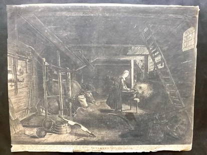
Sold2018Nolpe, Pieter after Paulus Potter 1650 Old Master Print"Autumnus" Large Etching Published C1650 by Frederick de Wit, Amsterdam. Engraved Pieter Nolpe after Paulus Potter. Possibly a slightly later impression, but printed on Laid Paper. Certainly pre-1800.See Sold Price
Sold2021FREDERIK DE WIT Zealand MapFREDERIK DE WIT Zealand Map, inscriptions to piece in Latin, subject an overhead map, measures 21 1/8 x 24 5/8 inches, yellow wooden frame, surface wear to frame, broken glass to lower portion of piecSee Sold Price
Sold2023Antique Map of England - 1670F. De Wit Antique Print 1670 - Amsterdam Map of England Image Size: 23.5 x 20 in. Overall Framed Size: 33 x 28.75 in. Framed behind glass.See Sold Price
Sold2024EARLY 18TH C. DUTCH CHART OF PACIFIC OCEAN BY FREDERIK DE WIT (1629-1706) WITH CALIFORNIA AS AN"Magnuum Mare del Zur, cum Insula California, De Groote Zuyd-Zee en't Eylandt California; Gedruck't Amsterdam by Frederick De Wit ince Calver Street". Handcolored copper engraving. Engraver: Romeyn deSee Sold Price
Sold2018Double page engraved map, Insula Malta AccuratissimeDouble page engraved map, Insula Malta Accuratissime Delineata Urbibus et Fortalitus Malta Frederico de wit Amstelodami, sight size 12" x 24". Provenance: Property from the Credit Suisse Americana ColSee Sold Price
Sold2016A Group of Four Hand-colored Engraved Maps, 19th/20thA Group of Four Hand-colored Engraved Maps, 19th/20th Century, Including three maps by Gerardus Mercator depicting Austria Archiducatus, Saltzburg and Flanders, and one map by Frederick de Wit depictiSee Sold Price
Sold202017th c Map of China- F. De WitChina.- De Wit (Frederick) Magn‘ Tartari‘, Magni Mogolis Imperii Japon‘ et Chin‘, nova descriptio, China and Tartary with Japan, ornamental cartouche, engraved map with hand-coSee Sold Price
Sold2020CHATELAIN, H. [North America], [1720]Chatelain, H. DRESSEE SUR LES PLUS NOUVELLES OBSERVATIONS DE MESSIEURS DE L’ACADEMIE... [Amsterdam, c.1720].Engraved map, outline colour, folds and minor imperfections, small loss affecting 4 lSee Sold Price
Sold2022De Wit, Map of North and South America, c. 1720Property of a Private Collector, Hilton Head Island, SC Description: Frederick De Wit (circa 1629-1706), Nova Orbis Tabula In Lucem Edita, A.F. De Wit, Amsterdam: Covens and Mortier, c. 1720, publSee Sold Price
Sold2020WIT, FREDERICK de. Novissima et Accuratissima TotiusWIT, FREDERICK de. Novissima et Accuratissima Totius Americae Descriptio. Double-page engraved map of the Americas showing California as an island. 20x23½ inches sheet size, ample margins; originSee Sold Price
Sold2017de Wit: Map of Southeast Asia, 1670Map: Tabula Indiae Orientalis Cartographer: Frederick De Wit Place & Date: Amsterdam / 1670 Size: 22 1/4" x 18 1/4" Condition: light overall age-toning A highly decorative and beautifully colored lateSee Sold Price
Sold2020De Wit Map of Africa ca. 1685Frederick de Wit (ca. 1630 – 1706), "Totius Africae Accuratissima Tabula," Amsterdam, ca. 1685. Hand colored map of Africa. African animals are included throughout the continent, and the decoraSee Sold Price
Sold2021De Witt. Angliae Regni et Walliae Principatus.[England] de Witt, Frederick (1630-1706). "Accuratissima Angliae Regni et Walliae Principatus." Amsterdam. c.1680. Copperplate engraved map. Hand colored cartouche and bordering. Shows most of the BriSee Sold Price
Sold2017Engraved Map Platte Grond de Kaap van St. Francois 1728Engraved map of “Platte Grond de Kaap van St. Francois..1728”, Amsterdam c 1728. Fine, measures 16 x 11”. Please note that this lot has a confidential reserve. When you leave a bid in advance ofSee Sold Price
Jun 07Freeman's | HindmanBELLIN, Jacques-Nicolas. Carte Reduite de L'Ocean Oriental ou Mer Des Indies. Paris, 1757. Second$150
Jun 07Freeman's | HindmanHOMANN, Johann Baptist. Amplissimae Regionis Mississipi Seu Provinciae Ludovicianae. Nuremburg, [ca$400(1 bid)
2 days LeftBonhamsPrince Alexis Soltykoff (1806-59), Voyages dans L'Inde Paris, Garnier, [1851]£1,600
Jun 08Early American History Auctions1853 Map of Portion of British North America and Gulf of St. Lawrence, by Henry Perley$260
6 days LeftTrillium Antique Prints & Rare BooksDe Jode, Rare, pub. 1593 - Electors of the Holy Roman Empire (Ordines Sacri Romani Imp: Ab Ottone$100(1 bid)
May 30NY Elizabeth ANTIQUE GEOMORPHOLOGY: 1782 POMPONII MELA DE SITU ORBIS ARMORIAL VELLUM BINDING$50
4 days LeftForum AuctionsMiniature Books.- Cicero (Marcus Tullius) De officiis libri III, Amsterdam, 1625 and 5 others,£100


![[MAP] DE WIT, F. NOVA ORBIS TABULA IN LUCEM EDITA: de Wit, Frederik. NOVA ORBIS TABULA, IN LUCEM EDITA. (Amsterdam: circa 1670s.) Beautiful map in exquisite full handcolouring, with elaborate corner scenes illustrating the four seasons and the Zodiac,](https://p1.liveauctioneers.com/8124/310027/165853624_1_x.jpg?height=310&quality=70&version=1700184289)


![CHATELAIN, H. [North America], [1720]: Chatelain, H. DRESSEE SUR LES PLUS NOUVELLES OBSERVATIONS DE MESSIEURS DE L’ACADEMIE... [Amsterdam, c.1720].Engraved map, outline colour, folds and minor imperfections, small loss affecting 4 l](https://p1.liveauctioneers.com/1124/187577/94368858_1_x.jpg?height=310&quality=70&version=1607095126)


![De Witt. Angliae Regni et Walliae Principatus.: [England] de Witt, Frederick (1630-1706). "Accuratissima Angliae Regni et Walliae Principatus." Amsterdam. c.1680. Copperplate engraved map. Hand colored cartouche and bordering. Shows most of the Bri](https://p1.liveauctioneers.com/179/209052/106367558_1_x.jpg?height=310&quality=70&version=1624651037)


![Prince Alexis Soltykoff (1806-59), Voyages dans L'Inde Paris, Garnier, [1851] (1 of 1)](https://p1.liveauctioneers.com/1043/328953/177308726_5_x.jpg?height=282&quality=70&version=1715163690)


