Sold2024Antique 1883 Eldridge's Chart Long Island SoundAntique 1883 Eldridge's Chart Long Island Sound From Newport to New York by Geo. Eldridge, Hydrographer and Published by S. Thaxter & Son. The map is framed in a metal map frame with no glass. The mapSee Sold Price
Sold2023Antique Framed Wayfarer's Map of New York 1939Antique Framed Wayfarer's Map of New York 1939. Framed. Signed by Charles D. Graves, possibly the map maker. Copyrighted 1939, Herbert C. Wyman, Pleasantville, NY. Wayfarer's Maps.See Sold Price
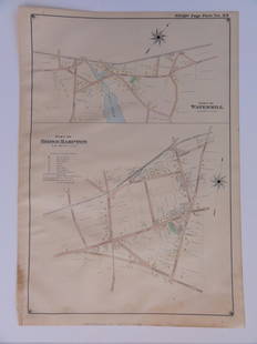
Sold2016Bridgehampton & Watermill, Long Island, 1902Original engraving published by E. Belcher Hyde from "Atlas of Suffolk County, Long Island, New York," Philadelphia, 1902. Map features family names, historic buildings and railroad routes. DimensionsSee Sold Price
Sold2017Buache: Antique Map of New York, Long Island, 1807Map: Ile de New-York Partie de Long-Island ou de l'Ile Longue et positions des armées Américaine et Britannique après le combat livré sur les hauteurs, le 27 Août, 1776. Maker: Buache, Jean NicolSee Sold Price
Sold2021Antique Framed Map of Columbia County, NY 1829Antique Framed Map of Columbia County, NY, dated 1829. Engraved by Rawdon Clark & Co, Albany, NY. Also marked Rawdon Wright, New York. Map includes locations of mills, churches and stage roads. NicelySee Sold Price
Sold2022Antique NEW YORK CITY MAP - FramedAntique New York City Map. 28” x 16” New York City map, circa 1860, hand-colored, double matted and framed to 38 ½” x 26”.See Sold Price
Sold2017Hardy: Antique New York City Fire Department Map, 1871Title: 1871 Hardy New York City Fire Department Map -- Map of the Boundaries of the Fire Department of the City of New York Made Under the Direction of the Fire Commissioners Cartographer: J Hardy YeaSee Sold Price
Sold2023Framed Antique Agricultural Map Of NY State, 1843Marked on lower left corner reads Agricultural map of the state of New York. Lith of G & W endicott New York, Map is colored in correspondence with the color of agriculture throughout the state. FrameSee Sold Price
Sold2018Colton: Antique Map of Massachusetts & Rhode IslandTitle/Content of Map: Massachusetts & Rhode Island by Colton Date Printed: Cartographer: J.H. Colton Size: 14" x 17" Material/Medium: Paper Provenance: New York From 'Colton's General Atlas'. Hand colSee Sold Price
Sold20231902 Cram Map of Long Island -- Map of Long Island New YorkTitle: 1902 Cram Map of Long Island -- Map of Long Island New York Cartographer: G Cram Year/Place: 1902, Chicago Dimensions: 9.8 X 12.4 in. Description: This is an attractive map of Long island withSee Sold Price
Sold2024Group of Ten Railroad Photographs, Maps, and Prints - New Jersey, Long Island, and New YorkGroup of Ten Railroad Photographs, Maps, and Prints - New Jersey, Long Island, and New YorkA mixed group of framed items for railroads in the New Jersey and New York area. Photographs include people oSee Sold Price
Sold2024Framed Oil on CanvasFramed Oil on Canvas. Dimension:33" by 23" From a Long Island, New York private Collector Please note the absence of a condition report does not imply that there are no condition issues with this lot.See Sold Price
Sold20241866 FRAMED MAP OF PRUSSIA GERMANYJOHNSON'S NEW YORK, HAND COLORED MAP, DATED 1866. LOOSE IN FRAME. 26" X 32" IN FRAMESee Sold Price
Sold20231902 National Publishing Company Wall Map1902 roll down wall map printed by the National Publishing Company New Railroad, Post office, Township, and County Map of New York which measures approximately 48" by 41". Condition - fine.See Sold Price
Sold2018Antique View of Charlotte Amalie, St. Thomas, 1870Title/Content of Map: Port of Charlotte Amalia, Island of St. Thomas Place & Date: New York (?) / 1870 Size: 6 3/8" x 5" Condition: full color; overall age toning A delightful colored engraving of theSee Sold Price
Sold2018Mitchell: Antique Map of New York State w/ city insetsCounty Map of the State of New York The beautifully detailed and colored county map of New York State from the 1870 edition of Mitchell's popular New General Atlas of the world. Framed by the vine motSee Sold Price
Sold2021Four Antique Hand Colored MapsA grouping of four small framed hand-colored engraved maps to include New England and New York by John Seller, A Mapp of the World by John Seller, Terra Firma, and Moscovia (Moscow) of Russia. All inSee Sold Price
Sold2023A Decorative Pictorial Map of The New York Worlds Fair by William L. Longyear (American, 1899-1980)A Decorative Pictorial Map of The New York Worlds Fair by William L. Longyear (American, 1899-1980). Framed. Designed and copyrighted by William Longyear. Lithographed in U.S.A by Polygraphic CompanySee Sold Price
Sold20151830 Map of Long Island SoundFrom New York to Mantock Point; published by E. & G.W. Blunt, NY. Printed in three sheetes 24" x 8 1/2", pressure mounted and framed, 26 1/4" x 84 1/4".See Sold Price
Sold2018LARGE ANTIQUE HAND COLORED MAP JEFFERSON COUNTY NYLarge antique hand colored map of Jefferson County, New York. Circa 1855. Framed in large wooden frame and laid down to canvas backing. Condition: mounted/laid on canvas for preservation, some areas rSee Sold Price
Sold20231732 H. Moll New England New York, NJ. & PA Map1732 H. Moll New England New York, New Jersey, and Pennsylvania with hand coloring. Framed, 8 by 11 1/2 in acid free matt. Beautiful Map.See Sold Price
Sold202118TH C. (1755) MAP OF N.Y. , PENSYLVANIA & NEW ENGLANDFRAMED 18TH C. (DATED 1755) 2 PART MAP "A MAP OF THE PROVINCE OF NEW YORK, WITH PART OF PENSILVANIA AND NEW ENGLAND / FROM AN ACTUAL SURVEY BY CAPTAIN MONTRESOR, ENGINEER 1755" - FRAME 59 1/4" X 39",See Sold Price
Sold2024Antique Photographs of New York (12)Twelve (12) silver gelatin prints, one framed, depicting images of New York, including Coney Island, Wall Street and Orchard Street, from 1900-1930s, by various photographers; group includes 3 modernSee Sold Price
Sold2015Map of Africa, 1864, Custom FramedOriginal engraving from the World Atlas by Johnson, New York, 1864. Map includes vignettes of Libera, Delta of the Nile, Cape Colony, Cape Verde Islands and St. Helena. Displayed in a wood frame and USee Sold Price
5 days LeftSanta Cruz Auction CompanyEdward Philip Browasky (1868-1939) Painting of Long Island 1918$300
BonhamsJEHAN GEORGES VIBERT (French, 1840-1902) Les Débuts d'Un Confesseur (framed 83.0 x 102.0 x ...$10,000
7 hrs LeftRobinhood AuctionsCharles Fazzino, "There's Music: New Jersey, New York, Long Island Too!!" Framed 3D Limited Edition$1,000
5 days LeftRobinhood AuctionsCharles Fazzino, "There's Music: New Jersey, New York, Long Island Too!!" Framed 3D Limited Edition$1,000
3 days LeftEldred'sAMERICAN SCHOOL (Mid-20th Century,), "April Shore Bellport" (Long Island, New York)., Oil on board,$70
May 28Robinhood AuctionsCharles Fazzino, "There's Music: New Jersey, New York, Long Island Too!! (Sky Blue)" Framed 3D$1,000
2 days LeftJasper52Orient. Western Pacific Islands. Fiji Tonga Melanesia Micronesia. TIMES 1958 map$30
Jun 09Estate Collection Auctioneer1985 Photo Felled Trees/Island Fire Painting by Susanne Slavick$200
Jun 06Freeman's | HindmanSTEVENSON, Robert Louis (1850-1894). Treasure Island. London, Paris & New York: Cassell & Company,$1,500
Jun 08Early American History Auctions1776 Map, PARTIE ORIENTALE DU CANADA, AVEC LA NOUVELLE ANGLETERRE, L'ACADIE... by P. Santini, Framed$950