Sold2024BALKANS.Turkey Greece.Roumelia Bulgaria Wallachia Servia Bulgaria 1882 old mapTITLE/CONTENT OF MAP: 'Turkey and Greece Roumania, Servia, Bulgaria, Bosnia & Montenegro' DATE PRINTED: 1882 IMAGE SIZE: Approx 51.5 x 35.5cm, 20.25 x 14 inches (Large); Please note that this is a folSee Sold Price
Sold2023OTTOMAN EMPIRE 1356-1897. Greece Bulgaria Servia Rumania Bosnia 1902 old mapTITLE/CONTENT OF MAP: 'The Ottoman Empire in Europe 1356-1897' DATE PRINTED: 1902 IMAGE SIZE: Approx 32.5 x 24.5cm, 12.75 x 9.5 inches (Large) TYPE: Antique colour map. This map was published in 1902See Sold Price
Sold2018Tallis/Rapkin: Antique Map of Turkey in Europe, 1851TITLE/CONTENT OF MAP: 'Turkey in Europe' Vignettes: The Bosphorus and Constantinople; Ali Pasha; Greek Caloyer. The Balkans: Rumilia, Macedonia, Albania, Wallachia, Moldavia, Bulgaria, Servia, Bosnia,See Sold Price
Sold2016Blaeu, W.: Walachia, Servia, Bulgaria, Romania Map 1635Map: Walachia, Servia, Bulgaria, Romania Publishing: Blaeu, W.: Amsterdam Date: 1635 Size: 15 x 20 inches Early edition of a very attractive map of the Balkans, shown during the occupation by the OttoSee Sold Price
Sold20181644 Blaeu Map of Eastern Balkans -- Walachia, Servia,Title/Content of Map: 1644 Blaeu Map of Eastern Balkans -- Walachia, Servia, Bulgaria, Romania Date Printed: 1644, Amsterdam Cartographer: W Blaeu Size: 15.2 x 20.1 in. This is a very nice map of theSee Sold Price
Sold2020Early 19th Century Hand Colored Transylvania MapMercator (Gerard) Transylvania, Sibenburgen; Walachia Servia, Bulgaria, Romania,northern Romania, and eastern Europe. Nicely hand colored and in good overall well kept condition. Not having been laidSee Sold Price
Sold2022(BULGARIA.) A. Krivoshiev; Freytag & Berndt. [Map of Bulgaria with Adjacent Countries].(BULGARIA.) A. Krivoshiev; Freytag & Berndt. [Map of Bulgaria with Adjacent Countries]. Massive color-printed Bulgarian-language map of the Baltic nation with parts of Turkey, Greece, North Macedonia,See Sold Price
Sold2017Birdseye view map colored lithograph "View of BeverlyBirdseye view map colored lithograph "View of Beverly Massachusetts 1886", published by W. A. Greenough & Co., Old Print Shop label on verso, sight size 20 1/4" x 26 1/2". Provenance: Property from CrSee Sold Price
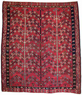
Sold2019Sarkoy KilimSarkoy Kilim 358 x 315 cm (11 ft. 9 in. x 10 ft. 4 in.) Bulgaria, Pirot ca. 1900 Condition: good, some old small repairs, stained, signs of wear Warp: wool, weft: wool Provenance: Austrian private colSee Sold Price
Sold2022Old map of the Red Sandalwood Pine Mountains in Qing Dynasty, ChinaOld map of the Red Sandalwood Pine Mountains in Qing Dynasty, ChinaSee Sold Price
Sold2021A Lot of 6 Old MapsIncluding old colored, including map of the Brabantia, largest map is 58 x 43 cm.See Sold Price
Sold2023Partie de l'Amerique Septentrionale… Northeastern USA. VAUGONDY 1755 old mapTITLE OF MAP (NOT PRINTED ON THE PAGE):'Partie de l'Amerique Septentrionale, qui comprend le Cours de l'Ohio, la Nlle. Angleterre, la Nlle. York, le New Jersey, la Pensylvanie, le Maryland, la VirginiSee Sold Price
Sold2017LARGE LOT OF OLD MAPSINCLUDES LANDMARK MAPMAKING BOOK. LARGE VARIETY OF MAPS.maps are old, some are taped to boards, very fragile, and/or torn/cracking. ***Additional photo links available at http://paceantiques.com/See Sold Price
Sold2024Willem Blaeu, Map of The AmericasAmsterdam, 1617. Together with "Early Maps" by Tony Campbell, Abbeville Press and "The United States in Old Maps and Prints, Eduard Van Ermen. 3 pieces Sight size: 16-1/2"h x 22"w Overall: 23-1/2"h xSee Sold Price
Sold2021FOUR-TIER GENERAL STORE CABINET.Wonderful old oak map cabinet sporting a older restoration that shows very nicely. These are getting more difficult to find, especially functional and with such a fantastic finish. Some very slight suSee Sold Price
Sold2018LYON, George Francis 91795-1832). A Narrative ofLYON, George Francis (1795-1832). A Narrative of Travels in Northern Africa, in the years 1818, 19, and 20. London: John Murray, 1821. 4to (268 x 211 mm). Engraved folding map (old small paper repairSee Sold Price
Sold2021Auguste Rodin, bronze sculpture, ex Sam SalzAuguste Rodin, bronze sculpture, ex Sam Salz, Auguste Rodin (French, 1840-1917), "Enfants au Lezard", conceived 1886, likely an old but posthumous casting, cast signed "A.Rodin" on base, 15.5"h x 9"lSee Sold Price
Sold2021William Livingstone Anderson Old Bridge Exquisite FrameAnderson, William Livingstone (English/American, 1856-1893), The Old Bridge, 1886, oil on canvas, signed and dated lower right, 21.75 x 30.5 inches, in a beautiful classical revival frame with scrolleSee Sold Price
Sold2021Painting, Carl W. BradienCarl W. Brandien (American, 1886-1965), "In Old Kyoto - Japan," c. 1930, oil on masonite, signed and titled lower right and verso, board (unframed): 19.75"h x 26.5"wSee Sold Price
Sold2023Highly collectible 1860 RR map of Texas, S. A. Mitchell, Jr.One of the most attractive atlas maps of Texas to appear in the mid-19th century. This authentic antique map (160 years old) was published when the Civil War was at its height. It shows the region froSee Sold Price
Sold2018Early 19th century School Girl Embroidery of OldEarly 19th century School Girl Embroidery of Old World-New world maps surrounded by floral garland decoration. Loss to silk and embroidery. Framed. Overall size: 21" x 29".See Sold Price
Sold2022Blaeu Novus Brasiliae Typus, c. 1640BLAEU, Willem Janszoon (1571-1638). Novus Brasiliae Typus. Engraved map with original hand color in full. Amsterdam. c. 1640. 18" x 21 7/8" sheet. Fine old color example of Blaeu's first map of BrazilSee Sold Price
Sold2023Aldro Hibbard, oil on canvasAldro Hibbard, oil on canvas, Aldro Thompson Hibbard (American, 1886-1972), Snowy Landscape, signed lower right, old auction stickers verso, 24"h x 30"w (sight), 37"h x 32"w (frame) Provenance: ChristSee Sold Price
Sold2024Map 1843 - First Settlement of 13 ColoniesMap 1843 - Showing the Dates of the First Settlements of the old 13 Colonies of the United States Map No. 11 Dated: Circa 1840 Dimensions: 6 x 4" Condition Report Toning. RoundedSee Sold Price
Jul 11Eldred'sCOULTON WAUGH (New York, 1896-1973), "The Map of Old Cape Cod"., 19.5" x 27.5" sight. Framed 21" x$125
Featured3 days LeftJasper52Hawaii & American Samoa. Pictorial state map by Ruth Taylor White 1935 old$140
Jun 25Freeman's | Hindman[Maps & Atlases] Seutter, Matth(ias).: Novus Orbis sive America...$300(1 bid)
336 Lots AwayBroward Auction GalleryAbraham Rosenthal (Russia,NY,MA,1886-1963) oil painting$110(2 bids)


![(BULGARIA.) A. Krivoshiev; Freytag & Berndt. [Map of Bulgaria with Adjacent Countries].: (BULGARIA.) A. Krivoshiev; Freytag & Berndt. [Map of Bulgaria with Adjacent Countries]. Massive color-printed Bulgarian-language map of the Baltic nation with parts of Turkey, Greece, North Macedonia,](https://p1.liveauctioneers.com/199/251723/130782277_1_x.jpg?height=310&quality=70&version=1655133895)


![[Maps & Atlases] Seutter, Matth(ias).: Novus Orbis sive America... (1 of 2)](https://p1.liveauctioneers.com/65/332523/179335174_1_x.jpg?height=282&quality=70&version=1717709447)


