Sold2017Bellin: Antique Map of Arabia & Red Sea, 1728Map: 1728 Bellin Map of Arabia and Red Sea -- Carte de la Coste d'Arabie, Mer Rouge, et Golfe de Perse Cartographer: J Bellin Year / Place: 1740, Paris Dimensions: 8.6 x 9.8 in. Condition: Very good.See Sold Price
Sold2017d'Anville: Antique Map of the Red Sea & Islands, 1789Map: Red Sea & It's Islands Date Printed: 1789 Cartographer: Harrison D' Anville Material/Medium: Paper Size: 15" x 21" Condition: Very Good. Small tear on top. Tear does not affect the Map. Printed iSee Sold Price
Sold2018Raynal/Bonne: Antique Map of Asia, 1780Asia. M. Bonne. André sculpteur. Overview map with links Poland and the red sea and right Japan and New Guinea. Copper engraving published in G.T.Raynal and R.Bonne; "Atlas De Toutes Les Parties ConnSee Sold Price
Sold2024Puerto Rico Antique Maps (3)Group of 3 antique folding map sea charts. One of Puerto Rico. Another of San Juan Harbor. The third a composite including Mayaguez Bay. Washington, D.C.: 1899. All fold as issued.See Sold Price
Sold2022Pieter Goos (1616-1675) - Antique Map of Celtic Sea - Antique Sea ChartPieter Goos (1616–1675). Accurate nautical chart of the Celtic Sea oriented north to the left. The title cartouche depicts Nereus and his children, the Nereids, with cross staffs and an astrolaSee Sold Price
Sold20231764 Bellin Map of the Red Sea Region -- Carte de la Mer Rouge et Partie de L'ArabieTitle: 1764 Bellin Map of the Red Sea Region -- Carte de la Mer Rouge et Partie de L'Arabie Cartographer: J Bellin Year / Place: 1764, Paris Map Dimension (in.): 8.5 X 14.2 in. This is a quite nice maSee Sold Price
Sold2017Bowen: Antique Map of Caspian Sea Reserve, 1747Map: Caspian Sea Reserve Date Printed: 1747 Cartographer: E. Bowen Material/Medium: Paper Size: 10 1/4" x 14" Condition: Excellent Handcolored, copperplate engraved. Printed in London. From "A CompletSee Sold Price
Sold2024Antique Map of Black Sea - John Rapkin - Europe - Asia - Turkey, Romania, Bulgaria, Ukraine"Black Sea". Fine map of the Black Sea, with an elaborate decorative border. The map shows eastern Europe and central Asia, including Turkey, Romania, Bulgaria, Ukraine, Russia, and Georgia.See Sold Price
Sold2019Barclay, James 1809 Antique Map. Turkey & Black Sea"Turkey in Europe with Asia Minor" Outline Hand Coloured Copper Engraved Map Published 1809, Leeds for "Barclay's Complete and Universal Dictionary of the English Language..." by the Rev. James BarclaSee Sold Price
Sold2023Raphael 1649 Engraving Vatican Moses and the Red SeaRaphael (Italian, 1483-1520). Moses and the Red Sea. Antique 1649 engraving on laid paper after the original from the series of etchings Biblical Scenes, after the frescoes by Raphael in the Vatican LSee Sold Price
Sold2024Raphael 1649 Engraving Vatican Moses and the Red SeaRaphael (Italian, 1483-1520). Moses and the Red Sea. Antique 1649 engraving on laid paper after the original from the series of etchings Biblical Scenes, after the frescoes by Raphael in the Vatican LSee Sold Price
Sold2022Raphael 1649 Engraving Vatican Moses and the Red SeaRaphael (Italian, 1483-1520). Moses and the Red Sea. Antique 1649 engraving on laid paper after the original from the series of etchings Biblical Scenes, after the frescoes by Raphael in the Vatican LSee Sold Price
Sold20221777 Rocher History of EGYPT Pharaoh Khufu Bible MOSES1777 Rocher History of EGYPT Pharaoh Khufu Bible MOSES Crossing Red Sea MAP 2v Pierre GueÌrin du Rocher was an 18th-century French Jesuit controversialist who is primarily remembered for his work TheSee Sold Price
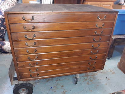
Sold2020Antique Map Architect Blue Print Sea Captain Chest 9 drAntique Map Architect Blue Print Sea Captain Chest 9 drawers custom made flat file cabinet for sea captain architect or blue prints,Maps, 9 drawers all on roller glides drawers work great very good coSee Sold Price
Sold2017Thomson: Antique Chart Map of Mediterranean Sea, 1817Chart of the Mediterranean Sea. Bay & roads of Marseilles. The harbour of Genoa. Plan of the Rock and Bay of Gibraltar, shewing the position of the combined fleet and attack of the battering ships inSee Sold Price
Sold2020Antique Map Architect Blue Print Sea Captain Chest 9 drcustom made flat file cabinet for sea captain architect or blue prints,Maps, 9 drawers all on roller glides drawers work great very good condition see all pics 34 1/2" tall x 41 1/2" wide x 28" deeploSee Sold Price
Sold20231843 SDUK Map of Arabian Peninsula, Red Sea, Egypt -- Arabia with Egypt, Nubia and AbyssiniaTitle: 1843 SDUK Map of Arabian Peninsula, Red Sea, Egypt -- Arabia with Egypt, Nubia and Abyssinia Cartographer: SDUK Year / Place: 1843, London Map Dimension (in.): 13.1 X 15.9 in. This a highly detSee Sold Price
Sold2017Mortier: Antique Map of Turkey Black Sea Coast, 1705Title/Content of Map: Kingdom of the Amazon's Northern Ancient Turkey's Black Sea Coast Date Printed: 1705-06 Cartographer: Pierre Mortier Material/Medium: Paper Size: 24" x 17" Copperplate engraved,See Sold Price
Sold2021Bruce, James 1813 Map of Masuah, Massawa. Red Sea"Plan of The Island and harbbour of Masuah" Copper Plate Published 1813, Edinburgh for "Travels to discover the source of the Nile" by James Bruce. Paper Size: 12 x 9.5 inch (30 x 24cm) Water stain inSee Sold Price
Sold2022AN ANTIQUE PRINTED MAP 'JAPAN INLAND SEA' London C.1870-; Lithograph Original colour. A finelyAN ANTIQUE PRINTED MAP 'JAPAN INLAND SEA' London C.1870-; Lithograph Original colour. A finely produced map of southern Japan, focusing on the area known as The Inland Sea - the waterways between theSee Sold Price
Sold2024Stieler, Adolf 1909 Antique Map. New Zealand - South Sea Islands, Pacific Australia HawaiiLithograph Map Published 1909 by Justus Perthes, Gotha for "Stielers Atlas of Modern Geography" by Adolf Stieler. Center fold as published. Paper Size: 19 x 15.5 inch (48 x 39cm) Good ConditionSee Sold Price
Sold2017Bellin: Antique Map of Iceland & Surrounding Seas, 1767Map: Carte Reduite de l'Islande et des Mers que en sont voisines Cartographer: Bellin Place & Date: Paris / 1767 Size: 32 1/2" x 21 1/2" Condition: b&w; light overall age toning, somewhat darker alongSee Sold Price
Sold2020(EGYPT.) Schenk, Peter; and Valk, Gerard. Aegypti(EGYPT.) Schenk, Peter; and Valk, Gerard. Aegypti Recentior Descriptio: Aegyptis & Turcis Elchibith; Arabibus Mesre & Misri, Hebraeis Mitsraim. Double-page engraved map of Egypt, the Red Sea and partSee Sold Price
Sold2017Plancius: Antique Map of Biblical Middle East, 1600Map: Tabula geographica, in qua Israelitarum, ab Aegypto ad Kenahanaeam usque profectiones omnes, et stationes describuntur Cartographer: Plancius/Cloppenburg Place & Date: Amsterdam / 1600 Size: 19 1See Sold Price
6 days LeftTrillium Antique Prints & Rare BooksSchedel, pub. 1493 - Pair of Pages of Engravings with Biblical Scenes$75
3 days LeftJasper52Africae / Africa by Bertius / Langenes 1603 old antique vintage map plan chart$260
3 days LeftJasper521770 French engraving map of Bonne,Rigobert Arabie. Mer Rouge et Golfe Persique$60
Featured3 days LeftJasper52Americae / America by Bertius / Langenes. The Americas 1603 old antique map$460
3 days LeftJasper52Anguilla St. Martin/Maarten Barts. Caribbean. US Navy sea chart 1899 (1917) map$300
3 days LeftJasper52Terrae Novae / Terra Nova by Bertius / Langenes. Newfoundland, Canada 1603 map$500
3 days LeftJasper52Famagusta harbour Salamis Cyprus Gazimagusa ADMIRALTY sea chart 1879 (1928) map$300
3 days LeftJasper52Antigua Falmouth English Harbour West Indies ADMIRALTY sea chart 1954 (1968) map$300
3 days LeftJasper52Cyprus anchorages Limassol Larnaca Akrotiri ADMIRALTY sea chart 1891 (1929) map$550
3 days LeftJasper52Daniae / Dania by Bertius / Langenes. Denmark, southern Norway & Sweden 1603 map$260
3 days LeftJasper52Antique sea 'Chart of the Islands of Cape Verd' [Verde]. MOUNT & PAGE 1758 map$260
3 days LeftJasper52Océan Atlantique Sud. Fernando de Noronha. Dépôt de la Marine sea chart 1873 map$260
3 days LeftJasper52Philippines Ports. Manila Cavite Anchorages. ADMIRALTY sea chart 1923 (1956) map$300
3 days LeftJasper52Americae Australis / Peruana by Bertius / Langenes. South America 1603 old map$300
3 days LeftJasper52South Coast of England. 175x65cm. Imray Laurie Norie Wilson sea chart 1913 map$300
3 days LeftJasper52Penang Island & harbour approaches. Malaysia. ADMIRALTY sea chart 1957 old map$300


![The Sea Coast of France from Ushent to Olone [Olonne]. MOUNT & PAGE 1758 map (1 of 1)](https://p1.liveauctioneers.com/5584/343699/186668710_1_x.jpg?height=282&quality=70&version=1726603887)


![Antique sea 'Chart of the Islands of Cape Verd' [Verde]. MOUNT & PAGE 1758 map (1 of 1)](https://p1.liveauctioneers.com/5584/343699/186668734_1_x.jpg?height=282&quality=70&version=1726603887)


