Sold2018Prévost: Chart of Trincomalee Bay, Sri LankaMap: Carte de la Baye de Trinquemale Cartographer: van der Schley/Prévost d'Exile Place/Date: Paris/The Hague / 1755 Size: 14" x 10 7/8" Condition: b&w; overall age toning; browning along left edge;See Sold Price
Sold20201780 Drouet Map of Pouzzoles Bay, Naples Italy -- CarteTitle/Content of Map: 1780 Drouet Map of Pouzzoles Bay, Naples Italy -- Carte du Golfe de Pouzzoles Avec Une Partie des Champs Philegreens dans la Terre de Labour Date: 1780 Cartographer: S DrouetSizeSee Sold Price
Sold20231668 Carte De La Terre Sainte, Holy Land1668 Map Titled "CARTE DE LA TERRE SAINTE, dresee pour bien entendre l'Histoire de FLAVIUS JOSEPH' and "Par P. DU-VAL Geographe ord du Roy Avec Privilege de Sa Maj.te' pour vingt ans 1668". Engraved cSee Sold Price
Sold2023Terre Ferme du Perou du Bresil..'. Spanish Main. DE L’ISLE/BUACHE 1745 mapTitle: Terre Ferme du Perou du Bresil..'. Spanish Main. DE L’ISLE/BUACHE 1745 map Description: Carte de la Terre Ferme du Perou du Bresil et du pays des Amazones [Map of Terra Firma (The SpanisSee Sold Price
Sold2018de Vaugondy / Fortin: Land of the IsraelitesMap: Carte de la Terre des Hebreux ou Israelites partagee selon l'ordre de Dieu aux douze tribus descendantes des douze fils de Jacob Cartographer: Robert de Vaugondy / Fortin Place/Date: Paris / 1778See Sold Price
Sold2018de l'Isle: Antique Map of Northern South America, 1730Map: Carte de la Terre Ferme, du Perou, du Bresil, et du Pays des Amazones Cartographer: de l'Isle / Buache Place & Date: Paris / 1730/1782 Size: 22 3/8" x 19 1/2" Condition: wash color; overall age-tSee Sold Price
Sold2017Liebaux: Antique Holy Land Tribal Map, 1767Map: Carte de la Terre Promise dressée par l'auteur du commentaire sur Josué Cartographer: Liebaux Place & Date: Paris / 1767 Size: 9" x 18 1/2" Condition: b&w folding map; backed to repair split foSee Sold Price
Sold2015Map of the Holy Land. Israel. 1835.Print of hand colored steel engraving titled „Carte de la Terre Sainte.Author C. V. Monin.Engraved by unknown.From the „Atlas Universel de Geography by C. V. Monin. Parsi. 1835.The Holy Land as aSee Sold Price
Sold2015Map of the Holy Land. Print in 1850.Map of the Holy Land since the Second Crusade in 1149 - 1291. Print in 1850.Print of steel engraving titled „Carte de la Terre Sainte depuis la deuxieme Croisade jusqua la fin de la domination ChretSee Sold Price
Sold2015Map of the Holy Land. Print in 1850.Map of the Holy Land divided into Kingdoms of Israel and Judahin 975 - 588 J.C. Print in 1850.Print of steel engraving titled „Carte de la Terre Sainte divisee en Royaumes D‘Israel et de Juda de 9See Sold Price
Sold2017A Blondeau: Mappe-Monde ou Carte Generale de la TerreMap: Mappe-Monde ou Carte Generale de la Terre, 1817 Maker: A Blondeau Date: 1817, Paris Description: An uncommon two hemisphere world map. The shown US border far exceeds into Canada north of MinnesoSee Sold Price
Sold2020DANET, GUILLAUME; after DE FER, NICOLAS. Mappe-Monde ouDANET, GUILLAUME; after DE FER, NICOLAS. Mappe-Monde ou Carte Generale de la Terre. Engraved decorative double-hemispheric wall map of the world on two sheets joined with additional title-banner and bSee Sold Price
Sold2021de Fer, Nicolas 1717 World Map. California as Island"Mappe-Monde ou Carte Generale de la Terre" Copper Engraved Map Published 1717, Paris for "Introduction a la Geographie" by Nicolas de Fer. Folds as issued. Paper Size: 14 x 10 inch (36 x 25cm) Very mSee Sold Price
Sold2022Map LotLot of maps including "CARTE / DE LA / PALESTINE / OF / TERRE SAINTE…1841" (unframed, overall in frame 26 1/2" x 20 1/2"), "CARTE DE L ISLE DE NIEVES" (sight 9" x 6 1/2", overall 16 1/2" x 14"),See Sold Price
Sold20241750 Bellin Map of South Africa's Saldana Bay -- Carte de la Baye de Saldana ou SaldaneTitle: 1750 Bellin Map of South Africa's Saldana Bay -- Carte de la Baye de Saldana ou Saldane Cartographer: J Bellin Year / Place: 1750, Paris Map Dimension (in.): 8.1 X 11.1 in. This is a nice map oSee Sold Price
Sold2017Bellin: Antique Map of Hudson Bay, Canada, 1757Title/Content of Map: 'Carte de la Baye de Hudson' Hudson Bay. Canada Date Printed: 1757 Image Size: Approx 24.0 x 33.5cm, 9.25 x 13 inches (Large); Please note that this is a folding map. Type: AntiqSee Sold Price
Sold20181757 Bellin Map of Hudson Bay and Labrador -- Carte deTitle/Content of Map: 1757 Bellin Map of Hudson Bay and Labrador -- Carte de la Baye de Hudson Date: 1757, Paris Cartographer: J Bellin Size: 8.5 x 11.8 in. This is a very nice map of Hudson Bay and LSee Sold Price
Sold2019Philippe Buache (1700-1773, Paris), "Carte de la PartiePhilippe Buache (1700-1773, Paris), "Carte de la Partie Meridionale d I'sle de Terre Neuve Avec l'Isle Royale, Isle Sable," 1741, H. - 14 in., W. - 20 1/2 in.See Sold Price
Sold2017Bellin: Antique Map of Chesapeake Bay, 1757Map: Carte de la Baye de Chesapeack et Pays Voisins Cartographer: Bellin Place & Date: Paris / 1757/1760 Size: 11 1/8" x 7 3/8" Condition: b&w; overall age toning; some minor spotting; a tiny repairedSee Sold Price
Sold2020c1757 Bellin Map of Hudson's BayA nicely engraved map of Jacques Bellin circa 1757 entitled "Carte De La Baye De Hudson", Very Good, trim to right margin, measures 13.75 x 9.5". Reserve: $70.00 Shipping: Domestic: Flat-rate of $5.00See Sold Price
Sold2017Bellin: Map of Hudson Bay, 1757Map: Carte de la Baye de Hudson Cartographer: Bellin Place & Date: Paris / 1757/1760 Size: 11 7/8" x 8 5/8" Condition: b&w; a small repaired puncture hole in the lower left quadrant (with slight lossSee Sold Price
Sold2024Rare Antique Map - Hudson Bay Chart - Old Map of North America - Bellin - Jacques"Carte de la Baye de Hudson". Its finely engraved, hand-coloring engraved map from the Dutch edition of acques Nicolas Bellin Histoire "General of Travel". Published in Amsterdam. A handsome chart ofSee Sold Price
Sold2019Bellin: Views of Patagonia & San Julian Bay, ArgentinaMap Title: Vue de la Terre des Patagons/Vue de la Baye St. Julien Cartographer: Bellin Place/Date: Paris / 1754/1760 Size: 6 1/2" x 4 1/2" (both views) Condition: b&w; light overall age toning; a spotSee Sold Price
Sold2022AN ANTIQUE PRINTED MAP BY N. BELLIN / J. VAN SCHLEY, Paris / Amsterdam c.1770. CARTE DE LA BAYEAN ANTIQUE PRINTED MAP BY N. BELLIN / J. VAN SCHLEY, Paris / Amsterdam c.1770. CARTE DE LA BAYE DEHISCE ...; Copperplate coloured. This chart for a Dutch edition of Prevost's 'Histoire des Voyages' fiSee Sold Price
May 30BonhamsREMBRANDT HARMENSZ VAN RIJN (1606-1669) La Résurrection de Lazare, grande plaque, circa 163...€2,800
Jun 23Schilb Antiquarian Rare Books1847 Don Quixote Jarvis ed Cervantes de la Mancha EARLY 2v American Philadelphia$40(2 bids)
May 30BonhamsREMBRANDT HARMENSZ VAN RIJN (1606-1669) Joseph et la Femme de Putiphar, 1634 (B39, NH128)Eau-for...€1,000
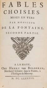
7 hrs LeftForum AuctionsFontaine (Jean de la) Fables Choisies, 2 vol., The Hague, Henry van Bulderen, 1688.£240
Jun 08Leon GalleryPhilippe de Pretot, Etienne Andre (c. 1710 - 1787) and William Walton - Carte de Canal des Isles₱30,000
Jun 08Potter & Potter Auctions[CONJURING – FRENCH]. [BINDINGS]. Group of 5 volumes. Inclu...$125
May 31Pananti Casa D'Aste S.R.L.Amedeo Modigliani (Livorno, 1884 - Parigi, 1920) - Les pampas Pampadour, 1916€70,000
Jun 08Potter & Potter AuctionsOZANAM, Jacques (1640 – 1718). L’Usage du Compas de Proport...$80
Jun 08Potter & Potter AuctionsVOLKMANN, Kurt (1897 – 1958) and Louis Tummers. Bibliograph...$100
Jun 07Freeman's | HindmanBELLIN, Jacques-Nicolas. Carte Reduite de L'Ocean Oriental ou Mer Des Indies. Paris, 1757. Second$150
6 days LeftBonhamsDALE CHIHULY (1941) Ensemble Sea Form, formé de deux pièces1995Edition Portland PressL...€1,600(1 bid)
6 days LeftBonhamsCHRISTOPHER RIES (1952) Sculpture Afterglow1997Signée 'Christopher Ries' et datée '5/5...€2,500


![[CONJURING – FRENCH]. [BINDINGS]. Group of 5 volumes. Inclu... (1 of 1)](https://p1.liveauctioneers.com/928/329228/177514339_1_x.jpg?height=282&quality=70&version=1715272280)


