Sold2020Michael Kenna, December Thaw, Gulf of FinlandMichael Kenna (British/American, b. 1953). December Thaw, Gulf of Finland, Russia, 1999. Silver gelatin print. Signed and dated lower right and numbered '18/45' lower left in pencil on the mount. MeasSee Sold Price
Sold2019La Svezia divisa ne'suoi Regni. Sweden & Finland.TITLE/CONTENT OF MAP: 'La Svezia divisa ne'suoi Regni di nuova projezione' Sweden divided in its Kingdoms, including Finland. The Baltic Sea and the Gulfs of Finland and Bothnia DATE PRINTED: PublisheSee Sold Price
Sold2023A Chart of the Gulf of Florida / W. Faden / Charing Cross 1794, 24" X 17 1/2".A Chart of the Gulf of Florida / W. Faden / Charing Cross 1794, 24" X 17 1/2".See Sold Price
Sold2017First state of this handsome sailing chart of The GulfA Chart of the Gulf of St. Laurence...Thomas Jefferys (c. 1719 – 1771). Copperplate engraved map. London: Sayer & Bennett, 1775. 21 1/2 x 29 inches sheet. First state of this handsome sailing chartSee Sold Price
Sold2020KEULEN, JOHANNES van. Pas Kaart van de Golff vanKEULEN, JOHANNES van. Pas Kaart van de Golff van Mexico. Double-page engraved chart of the Gulf of Mexico. 21¼x24¼ inches sheet size, ample margins; light staining, small edge chips or tearsSee Sold Price
Sold2018Coulier: Maracaibo (Venezuela) Lighthouse ChartCoulier: Maracaibo (Venezuela) Lighthouse Chart A superbly detailed chart of the Gulf of Venezuela and part of Lake Maracaibo, identifying the location of the "Proposed Maracaibo Lighthouse," from PhiSee Sold Price
Sold2023British Admiralty Chart #1917 - Van. Isl & Gulf of Georgia, Ex. Coll Admiral Nelles, 25".British Admiralty Chart #1917 - Van. Isl & Gulf of Georgia, Ex. Coll Admiral Nelles, 25".See Sold Price
Sold2020Central America Caribbean Gulf of Mexico chart PortsTITLE/CONTENT OF MAP: 'Central American and West Indian Ports; Inset The Pacific Coast from San Diego to Vancouver; San Francisco; Aleutian; The Pacific Coast from Seattle to Dutch Harbor; Bermudas; KSee Sold Price
Sold2024Central America Caribbean Gulf of Mexico chart Ports lighthouses LARGE 1952 mapTITLE/CONTENT OF MAP: 'Central American and West Indian Ports inset The Lesser Antilles; The Windward Passage; Bermudas; Kingston; Havana; Salina Cruz; Coatzacoalcos; Willemstad, Curacao' DATE PRINTEDSee Sold Price
Sold2024Central America Caribbean Gulf of Mexico chart Ports lighthouses LARGE 1927 mapTITLE/CONTENT OF MAP: Central American and West Indian Ports [inset The Lesser Antilles; The Windward Passage; Bermudas; Kingston; Havana; Salina Cruz; Puerto Mexico; Mouths of the Mississippi] DATE PSee Sold Price
Sold2021Bruce, James 1813 LG Map. Arabian Gulf"To The King. This Map, containing a Chart of the Arabian Gulf with it's Egyptian, Ethiopian and Arabian Coasts, from Suez to Bab el Mandeb..." Copper Plate Published 1813, Edinburgh for "Travels to dSee Sold Price
Sold2018Caribbean & Gulf of Mexico.- Moll (Herman) A Map of theCaribbean & Gulf of Mexico.- Moll (Herman) A Map of the West-Indies or the Islands of America in the North Sea, a large and impressively detailed chart, showing parts of Louisiana and Florida in trianSee Sold Price
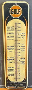
Sold2024Gulf No Nox Gasoline & Gulfpride Oil Tin Service Station ThermometerAn excellent displaying example of this seldom seen Tin Service Station Thermometer from Gulf advertising for Gulf Gasoline as well as Gulfpride Motor Oils showing various chart recommendations througSee Sold Price
Sold2023Trinidad west part Gulf of Paria West Indies ADMIRALTY sea chart 1869 (1951) mapWest Indies - Trinidad Island and Gulf of Paria' by Bocas Del Dragon to Icacos point from the surveys by Commr. Alun Jones, R.N., and the Officers of H.M. Surveying Ship "Challenger" 1936. Eastern porSee Sold Price
Sold2023Trinidad Island. Eastern Part. West Indies. ADMIRALTY sea chart 1869 (1950) mapTrinidad Island - Eastern Portion' by Bocas Del Dragon to Icacos point from the surveys by Commr. Alun Jones, R.N., and the Officers of H.M. Surveying Ship "Challenger" 1936. Eastern portion of Gulf oSee Sold Price
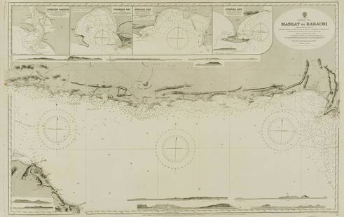
Sold2022Middle East.- Oman.- Admirality Hydrographic Office (The) Maskat to Karachi, engraved chart, 1916.Middle East.- Oman.- Admirality Hydrographic Office (The) Maskat to Karachi, showing the coast from Maskat to Karachi, the Gulf of Oman, with inset maps of Sonmoyani Harbour, Chahbar Bay, Gwatar Bay aSee Sold Price
Sold2024Gulf of Mexico. Caribbean West Indies. USCGS sea chart 1928 (1930) old mapTITLE/CONTENT OF MAP: 'Gulf of Mexico' DATE PRINTED: Published 1928. Reissued 1930. Corrections to 1930 IMAGE SIZE: Approx 89.0 x 107.5cm, 35 x 42.25 inches (Large); Please note that this is a foldingSee Sold Price
Sold2019J. Wells, "Chart of Mississippi River from the OhioJ. Wells, "Chart of Mississippi River from the Ohio River to the Gulf of Mexico," 1877, H.- 10 3/4 in., W. - 7 3/4 in.See Sold Price
Sold2021Chart of the Landfalls of Cabrillo and Ferrelo On theTitle: Chart of the Landfalls of Cabrillo and Ferrelo On the Pacific Coast Cartographer: DAVIDSON, GEORGE/FERDINAND WESCAAHL Publisher: GPO Height: 21 Width: 20.25 "from the Gulf of California to latiSee Sold Price
Sold20151833 J W Norie “New Chart of the Coast of America1833 J W Norie “New Chart of the Coast of America from New York & Philadelphia to the Strait or gulf of Florida†J Stephenson, engraver (rough as found condition, tears & creases, losses, maSee Sold Price
Sold2020(16) MARINE CHARTS & (2) JACK GRAY PRINTS, ROLLEDIncluding: "Windward Passages and Gulf of Mexico, including the Bahamas and West Indies Islands", Wilson, 1899; "Puerto Rico and the Virgin Islands", Imray, 1884; "Massachusetts Bay and the Coast ChatSee Sold Price
Sold2020THOMSON, JOHN. Atlantic or Western Ocean.THOMSON, JOHN. Atlantic or Western Ocean. Double-page engraved chart of the northern Atlantic Ocean showing a pronounced outline of the Gulf Stream. 20½x25½ inches sheet size, ample margins;See Sold Price
Sold2018Map Shewing Moves of the Mandans - George CatlinChart Shewing the Moves of the Mandans & The Place of Their Extinction Map shows from Gulf of Mexico to Lake Superior with large section of Sioux Country noted. Marks MSee Sold Price
Sold2017EPHEMERASixteen pieces including ten 18th c. maps and moon charts of Africa, British America (Canada), South America, West Canada, Mexico, California and Texas, England, Finland, Bothnia, Aberdeen Shire, PolaSee Sold Price
BonhamsEAST AFRICA DE WIT (FREDERICK) Occidentalior Tractus Indiarum Orientalium a Promontorio Bonae Sp...£300
7 days LeftAkiba GalleriesHoward Finster (American, 1916-2001) "Desert Storm War In Gulf" Mixed Media$200(5 bids)
2 days LeftRichmond AuctionsGrand Prize Beer Gulf Brewing Houston TX 15" Double Bubble Advertising Clock$350(4 bids)
5 days LeftHeritage Auctions70277: An Olmec Jade Spoon Pendant Gulf Coast, Mexico,$750
Jun 08Auktionshaus SchreiberOiva TOIKKA (1931 - 2019). 6 year cubes / glass sculptures. Finland.€100(1 bid)
5 days LeftHeritage Auctions70273: An Olmec Jade Pendant Gulf Coast, Mexico, c. 12$600
2 days LeftRichmond AuctionsGrand Prize Beer Gulf Brewing Houston TX 15" Double Bubble Advertising Clock$350(4 bids)
Jun 29JM Hobby Supply and Railroad Artifact AuctionsGulf Mobile and Ohio RR Right Adlake Caboose Marker Lamp$100(1 bid)
Jun 08Simpson Galleries, LLC.MICHAEL FRARY (American/Texas 1918-2005) A PAINTING, "Fishing Boats in the Gulf," 20TH CENTURY$400
Jun 15Carstens GalleriesPaavo Tynell Style Magnificent Chandelier Fantasia Series. H: 32" D: 24". Finland.$3,750


![Central America Caribbean Gulf of Mexico chart Ports lighthouses LARGE 1927 map: TITLE/CONTENT OF MAP: Central American and West Indian Ports [inset The Lesser Antilles; The Windward Passage; Bermudas; Kingston; Havana; Salina Cruz; Puerto Mexico; Mouths of the Mississippi] DATE P](https://p1.liveauctioneers.com/5584/316569/169897699_1_x.jpg?height=310&quality=70&version=1706046386)