Sold20222 PC. FRAMED EARLY ENGLISH MAPS2 PC. FRAMED EARLY ENGLISH MAPS: Comprising; 1- Hand-colored Oxford Shire map, by Robert Morden. 1- An accurate map of the county of Bedford divided into its hundreds. Drawn from a late survey, & illuSee Sold Price
Sold2020Early 19th Century Map of VermontHAND DRAWN, COLORED MAP OF VERMONT BY ESTHER CONKEY OF ORWELL OCT 22 1825 ON PAPER 21"X17" LINEN BACKED TORN THRU CENTER OF MAP WITH SOME LOSSES, TAPE RESIDUE,TONING AND SPOTTING - IMPERFECTIONSee Sold Price
Sold2015EARLY MAPS OF SKOWHEGAN AND MADISON, MAINEEARLY MAPS OF SKOWHEGAN AND MADISON, MAINE Early hand-drawn and colored map of Skowhegan, Maine, 15 1/2" x 12 1/2", a copy of a 1790 map executed in Boston, Feb. 2, 1791and showing the Kennebec and SaSee Sold Price
Sold2021LATE 19TH & EARLY 20TH C. KANSAS MAPS LOT OF 6LATE 19TH & EARLY 20TH C. KANSAS MAPS LOT OF 6 Lot of late 19th and early 20th century maps of Kansas. Includes 5 Hand drawn and hand colored maps from the 1880s. Fort Scott, Eldorado, Emporia, SalinSee Sold Price
Sold20171815 South Carolina Land Survey & 1829 DeedPen & ink, hand drawn survey map with coloring, dated July 28, 1815 describing 211 acres on Tiger River in Union District belonging to William Linam, William Lucas and heirs of Jeremiah Hamilton, Esq.See Sold Price
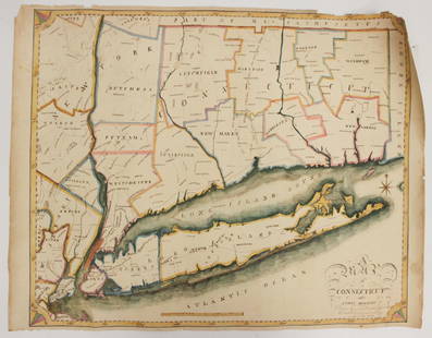
Sold2023EARLY CONNECTICUT MAPHand drawn and colored; "Connecticut and Parts Adjacent", "drawn by Miss. Elizabeth L. Tredwell" "Christ Church Academy 1820", several edge tears; 23" x 30", F-GSee Sold Price
Sold2016Map of Holy Lands. 1854.Print of hand colored steel engraving .Drawn by L. Dussieux. Engraved by unknown.From „Atlas General De Geographie physique, politique et historique par L. Dussieux. Atlas de Geographie ancienne, duSee Sold Price
Sold2023F. Gray's Idaho, Montana and Wyoming Map 1870Featured in this lot is an excellent, hand-colored early map of Idaho Territory, Wyoming Territory and Montana Territory, published by O.W. Gray and drawn by Frank A. Gray. Wyoming is shown with onlySee Sold Price
Sold2022(ON-19) EARLY TRAIL OF TEARS EPHEMERA DOCUMENTS CHOCTAW NATIONEarly 19th collection of documents that includes two maps. The group with no odors and in clean condition. 1) A map with cover note that is hand drawn and lightly colored showing vacant landsaround deSee Sold Price
Sold2016(3) 19th c. hand colored maps of ConnecticutGrouping of three circa 1867 hand colored maps and one black and white advertisement from the "Atlas of New York and Vicinity" by Beers, Ellis & Soule, the drawings based on land surveys performed undSee Sold Price
Sold2015(3) 19th c. hand colored maps of ConnecticutGrouping of three circa 1867 hand colored maps from the "Atlas of New York and Vicinity" by Beers, Ellis & Soule, the drawings based on land surveys performed under the direction of F.W. Beers, includSee Sold Price
Sold2016c. 1670 Engraved Holy Land + Mediterranean MapHistoric Maps c. 1670 Engraved Map of the Holy Land & Mediterranean Sea c. 1670, Historic Hand-Colored Engraved Map entitled: “Terra Sancta sive Promissionis olim Palestina recens delineata,” by FSee Sold Price
Sold2022Thomas Bowen,1778, Map, Western Atlantic Ocean"Thomas Bowen, London 1778, A New & Accurate Chart of the Western or Atlantic Ocean Drawn from Surveys and most approved Maps & Charts" by Thomas Bowen. Hand colored, modern framing. Dimensions:SightSee Sold Price
Sold2022Map of Suriname – 18th Century – With Notation ofNieuwe Kaart van Suriname vertonende de stromen en land-streken van Suriname, Comowini, Cottica, en Marawini. Map of Suriname, hand-colored. Amsterdam: J. Ottens, [early 18th century].A detailed map oSee Sold Price
Sold2021Rapkin, John 1857 HC Map of Siege of Sebastopol, CrimeaHand Colored Steel Engraved Map Published 1857, London for "England's Battles by Sea and Land..." by Lieut-Colonel Williams. Centre fold as issued. Drawn & Engraved by John Rapkin. Paper Size: 14 x 10See Sold Price
Sold2021Rapkin, John 1857 HC Map of Siege of Sebastopol, CrimeaHand Colored Steel Engraved Map Published 1857, London for "England's Battles by Sea and Land..." by Lieut-Colonel Williams. Centre fold as issued. Drawn & Engraved by John Rapkin. Paper Size: 14 x 10See Sold Price
Sold20161831 South Carolina Hand-Drawn Land Surveydated and completed at the request of Mr. Jackson Evans, the plat records a 50 acre track in the Newberry district of South Carolina along the banks of the Tiger River and the Cain Creek. The old 96 rSee Sold Price
Sold2022Early Hand Drawn Map of United States in 1817,by Mary Young, image area 20" X 30" plus frame.See Sold Price
Sold202319th & 20th C. Survey Maps19th and 20th C. Survey Maps, including: 1886 hand drawn survey map, Lancaster Co., Virginia, at the Confluence of The Rappahannuck and Carrottoman rivers, 18" x 25' with photo copy of survey, plus 19See Sold Price
Sold2021Artwork LotLot including early hand drawn maps (largest 14" x 16"), floral watercolor (20" x 12 3/4"), painting on panel marked LRC "LT Keeler Kimpo Korea '53" (12 1/4" x 16 1/4").See Sold Price
Sold2018Hand drawn and colored map of Massachusetts includingHand drawn and colored map of Massachusetts including Cape Cod, Plymouth, Kingston, Duxbury, etc. professionally matted and framed. sight size: 15 1/2" x 19 1/2" Provenance: Property from Credit SuiSee Sold Price
Sold20211794 Georgia Land Grant Survey & Wax Seal Framed18th century. Hand drawn Georgia land survey with original wax seal. Very nice framed for display. Framed: H32" W12 1/2" Sold from the collection of a Greenville gentleman collector.See Sold Price
Sold20211794 Georgia Land Grant Survey & Wax Seal Framed18th century. Hand drawn Georgia land survey with original wax seal. Very nice framed for display. Framed: H32" W12 1/2" Sold from the collection of a Greenville gentleman collector.Montgomery Co Ga aSee Sold Price
Sold2021Hand Drawn Map of "Edgefield Area Potteries"Framed hand drawn and colored map "Edgefield Area Potteries: 1810-1880", signed and dated "C. Alderman, Penman / 2007"; map identifies the 19th century pottery sites in the Edgefield District of SouthSee Sold Price
3 days LeftJasper52Large Antique French map GERMAN EMPIRE 1792 colored by POIRSON engraver Basset$170
4 days LeftJasper52ISLINGTON PARISH 1735 Holloway Highgate Crouch End. Scarce HAWKSWORTH 1811 map$550
4 hrs LeftCarlsen Gallery, Inc.EARLY HAND COLORED MAP OF COLONIAL NEW ENGLAND 19" X 21 3/4"$700(5 bids)
6 days LeftConestoga Auction Company Division of Hess Auction GroupEarly 19th C. Southeastern PA Fraktur Vorschrift.$300(2 bids)
Sep 29Grace Auction & Estate Gallery LLCAntique Hand Colored Map Johann Baptist Homann. Fluviorum in Europa Principis Danubii$100
Sep 29Grace Auction & Estate Gallery LLCAntique Hand Colored Map Bernardo Brognolo Veronae Vrbis Territorivm, Theatrum Orbis Terrarum$100
6 days LeftBrunk AuctionsJohn Mitchell - A Map of the British and French Dominions in North America, 1755-1757$24,000


![Map of Suriname – 18th Century – With Notation of: Nieuwe Kaart van Suriname vertonende de stromen en land-streken van Suriname, Comowini, Cottica, en Marawini. Map of Suriname, hand-colored. Amsterdam: J. Ottens, [early 18th century].A detailed map o](https://p1.liveauctioneers.com/3506/232707/120467405_1_x.jpg?height=310&quality=70&version=1641394058)


