Sold2024EARLY MAP OF GREECE, ZULIANI, G."Graecia Antiqua, Venetiis, 1785, apud Antonium Zattaet Filios, cum Privil. Excel, Sen." In black and gold molded frame, matted under plexiglass, OS: 23" x 19 1/2", SS: 17" x 12".See Sold Price
Sold2021Early Map of Greece and EnvironsEarly and Rare map by Jean Covens and Corneille Mortier of Greece, the Aegean, Asia Minor and the lower Balkans. 19 ½ x 26 inches (approximately)See Sold Price
Sold2021Nice early map of Maine by T. G. Bradford, 1835Title: Nice early map of Maine by T. G. Bradford, 1835 Description: Bradford maps can be spotted a mile away. The signature light blue frame is the first giveaway. The second is the unique look to theSee Sold Price
20241837 Map of Greece. Early post-independence era By A. PerrotTitle: 1837 Map of Greece. Early post-independence era By A. Perrot Date/Period: 1837 Materials: Copperplate engraved Size: 7 x 10 3/4” This is a map of Greece, the early post-independence era fSee Sold Price
Sold2024J&G Menzies, engraved map of AfricaJ&G Menzies, engraved map of Africa, Early 19th c., hand-colored engraving on paper, labeled "No 47" upper right, matted and framed under glass, 20.5"h x 23"w (sight), 28.5"h x 31"w (frame)See Sold Price
Sold20231733 c. DeLisle Map of Ancient Southern Greece -- Graeciae Pars MeridionalisTitle: 1733 c. DeLisle Map of Ancient Southern Greece -- Graeciae Pars Meridionalis Cartographer: G DeLisle Year / Place: 1733 c., London Map Dimension (in.): 26.4 x 21.7 in. A highly attractive, largSee Sold Price
Sold20231574 Ruscelli Map of Greece and Balkans -- Europae Tabula IXTitle: 1574 Ruscelli Map of Greece and Balkans -- Europae Tabula IX Cartographer: G Ruscelli Year / Place: 1574, Venice Map Dimension (in.): 7.4 X 9.7 in. This is an excellent Ptolemaic map of Greece,See Sold Price
Sold2022EARLY MAP "AMERICA"John Speede 1626, Thomas Bassett / Richard Chillwell, Abraham Goos; "The Description of America", hand colored, center fold, slight foxing, framed size 19" x 23 1/2", G-G+See Sold Price
Sold2022EARLY MAP OF BRITAINJohn Speede / Thomas Basett, bookplate "Sanon Heptarchy" on reverse, hand colored, center fold, slight toning, framed size 19" x 23 1/2", G-G+See Sold Price
Sold2022EARLY MAP OF AFRICA"Africae" "Newly Done into English John Speede / G. Humble 1626" engraved by Abraham Goos, bookplate "The Description of Africa" on reverse, hand colored; minor tear, foxing, toning, tape marks; frameSee Sold Price
Sold2024G. De L'Isle/Covens & Mortier Map Of GreeceDrawn up on a number of old and new memories, on those of M. Wheler and Tournefort, on the astronomical observations of M. Vernon, P. Feuillee Minime & C By G. De L'Isle of the royal of acedemy sciencSee Sold Price
Sold2021Two Early Maps of the Texas RepublicTwo Early Maps of the Texas Republic each engraved with hand-coloring, the first by T. G. Bradford, engraved by G. W. Boynton, published Boston, 1838; the second by C. S. Williams, from A New UniversaSee Sold Price
Sold2021Important Texas Historical MemorabiliaCollection of Important Texas Historical Memorabilia including a 1936 Centennial state flag, two early maps of Texas - the first a "Map of Texas as a Republic" by T. G. Bradford, engraved by G. W. BoySee Sold Price
Sold2022Pre-statehood map of District of Maine, 1814An important, original early map of Maine six years before achieving statehood, and several years before the northern and upper northeastern boundaries are finally settled. Engraved by John G. WarnickSee Sold Price
Sold2017Bradford: Antique Map of Massachusetts, 18351835 Bradford map of Massachusetts. Nice early map of the state of Massachusetts by Thomas Gamaliel Bradford. Original hand coloring. Clean with good margins. 7.5 x 10 inches. Thomas G. Bradford was tSee Sold Price
Sold20191892 Cram Map of Denver and San Francisco -- DenverReserve Reduced! Title/Content of Map: 1892 Cram Map of Denver and San Francisco -- Denver [verso] San Francisco Date: 1892, Chicago Cartographer: G Cram Size: 10.3 X 13.4 in. This is a nice early mapSee Sold Price
Sold2020Greece 1888Title/ Content of Map:Greece 1888 Date Printed: 1888 Cartographer: Material/Medium: Paper Dimensions: approx. 14x 21 inches Additional Information: John G. Lonngren & Son Standard Atlas Reserve: $25.0See Sold Price
Sold2017Bradford: Antique Map of Argentina Chile Paraguay, 1835Title/Content of Map: Early Map of Argentina, Chile, Paraguay & Uruguay Date Printed: 1835 Cartographer: T. G. Bradford Material/Medium: Paper Size: 9 1/2" x 12" A Comprehensive Atlas Geographical, HiSee Sold Price
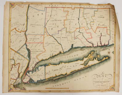
Sold2023EARLY CONNECTICUT MAPHand drawn and colored; "Connecticut and Parts Adjacent", "drawn by Miss. Elizabeth L. Tredwell" "Christ Church Academy 1820", several edge tears; 23" x 30", F-GSee Sold Price
Sold20171768 Millar Map of Greece, Macedonia and Asia Minor --Title/Content of Map: 1768 Millar Map of Greece, Macedonia and Asia Minor -- A Correct Map of Ancient Greece Date Printed: 1768 c. Cartographer: G Millar Size: 14.3 x 9.3 in. A very nice map of GreeceSee Sold Price
Sold2023Early Luxembourg Mapunframed. Cartographer: Jacob van Deventer. Circa 1581-88; from Civitates Orbis Terrarum. Liber tertius. Köln, G. Kempen, 1581-88. (Koeman, B&H3). 16" high, 18 3/ 8" wide. Dry mounted, foxing, seam aSee Sold Price
Sold20201822 Map of GreeceAuthor: Hamm Title: 1822 Map of Greece Medium: Ink on Paper Dimensions: 8.5"X10.5" Map of Greece dated 1822. Engraved by P.E. Hamm in Philadelphia. Hamm's work, one of the early cartographers doing woSee Sold Price
Sold2021EARLY CITY MAP OF BALTIMORE 1855Framed, plate no 23; toned; image 14 1/2" x 17 1/2", G-VGSee Sold Price
Sold20231574 Ruscelli Map of the Nile River Delta -- Egitto Nuova TavolaTitle: 1574 Ruscelli Map of the Nile River Delta -- Egitto Nuova Tavola Cartographer: G Ruscelli Year / Place: 1574, Venice Map Dimension (in.): 7.1 X 9.6 in. This is an excellent early Ptolemic map oSee Sold Price
3 days LeftTrillium Antique Prints & Rare BooksPtolemy & Magini, pub. 1620 - 4 Maps of European Countries: Spain, Portugal, France, & Greece$50
Jun 06Freeman's | HindmanTHOREAU, Henry David (1817-1862). [The Season Books]. Early Spring in Massachusetts. 1881. --$400
Jun 12Dan Morphy AuctionsINDIAN TERRITORY - DEPARTMENT OF THE INTERIOR GENERAL LAND OFFICE, C.1883$100
May 30NY Elizabeth 1709 SEPTUAGINT GREEK BIBLE ILLUSTRATED WITH MAPS, VINTAGE VELLUM BOUND VERSION$50(1 bid)
3 days LeftTrillium Antique Prints & Rare BooksPrevost - Chart of the Gulf of Mexico (with Florida & Lousiana)$50(1 bid)
3 days LeftTrillium Antique Prints & Rare BooksPtolemy & Magini, pub. 1620 - 3 Maps of Italy: Rome, Naples, Lombardia$55(2 bids)
Jun 23Schilb Antiquarian Rare Books1743 ENGLISH Works of Hesiod Greek Philosophy Theogony Homer Mythology Cooke$1


![1892 Cram Map of Denver and San Francisco -- Denver: Reserve Reduced! Title/Content of Map: 1892 Cram Map of Denver and San Francisco -- Denver [verso] San Francisco Date: 1892, Chicago Cartographer: G Cram Size: 10.3 X 13.4 in. This is a nice early map](https://p1.liveauctioneers.com/5584/136495/69275237_1_x.jpg?height=310&quality=70&version=1550614831)


![THOREAU, Henry David (1817-1862). [The Season Books]. Early Spring in Massachusetts. 1881. -- (1 of 1)](https://p1.liveauctioneers.com/197/329405/177652637_1_x.jpg?height=282&quality=70&version=1715364568)


