Sold2022Vintage RR map of Maryland & Delaware, 1850Excellent 1850 map of Maryland and Delaware with a chart of Chesapeake Bay Steamboat Routes. Published a decade before the Civil War and during an explosion in the country's railroad routes, the map aSee Sold Price
Sold2023Scarce RR map of Georgia, Cowperthwait 1850Steel engraved, hand-colored vintage map of Georgia. Excellent detail in depicting the roads and railroads that crisscross the state. Railroad lines highlighted in red; canals highlighted in blue. PolSee Sold Price
Sold2022Excellent 1850 map of Maine with highlighted Railroad routesHighly detailed and interesting engraved map of Maine, hand colored by counties. Railroads highlighted in orange-red. Locates towns, rivers, mountains, lakes, railroads, coastal features, stage routesSee Sold Price
Sold2023Authentic vintage 1850 RR map of MississippiGreat railroad map titled A New Map of Mississippi with its Roads & Distances. Dated 1850 and reissued in Cowperthwait’s 1855 New Universal Atlas. There were two 1855 editions of CowperthwaitSee Sold Price
Sold2022Great 1850 map of Alabama in excellent conditionScarce map of Alabama from a company whose maps were among the finest issued in the period. Shows Alabama at an important and interesting period in its history. It is filled with topographical detailsSee Sold Price
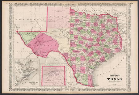
Sold2023Excellent example of Johnson’s Texas, 1866Authentic and impressive vintage map of Texas. One of the more collectible maps to be produced in the mid-19th century. A highly desirable map that details the state in full. Shows the elevated TableSee Sold Price
Sold2022Vintage Map of Wyoming Sgd. Grace Raymond Hebard.A Vintage illustrated map called "History and Romance of Wyoming", by Grace Raymond Hebard and Paul M Paine. It is Signed lower right, "Grace Raymond Hebard". The Map is in excellent condition, and meSee Sold Price
Sold20241850 map of Holland and Belgium – Mitchell/CowperthwaitAn authentic vintage map of what is known as the Low Countries—Holland and Belgium. With an 1850 copyright date and found in an 1853 edition of Mitchell’s New Universal Atlas. A very cleanSee Sold Price
Sold2018Braniff Airlines: Vintage Map of Americas Routes, 1944Title/Content of Map: 1944 Braniff Airlines Americas Routes -- Braniff Airlines Americas Routes Date Printed: 1944 Cartographer: Braniff Airlines Size: 10 x 7 in. An excellent and off-beat Braniff airSee Sold Price
Sold2021(3) 19TH C. MARITIME HANDBOOKSIncluding: Blunt's American Coast Pilot, 15th edition, May 1847, in sailcloth wrap, well-used but complete, scarce in any condition; PLUS ibid 16th edition, with fold-out map, 1850, full calf; PLUS BlSee Sold Price
Sold2022Scarce 1850 Railroad map of Ohio by CowperthwaitOriginal vintage map of Ohio from an atlas that is becoming increasingly difficult to obtain. On this fully hand colored map, railroad routes are boldly highlighted in orange-red as an indication of hSee Sold Price
Sold2024Great vintage RR map of N. Carolina from scarce Colton atlasExcellent map of North Carolina just one year after being readmitted to the Union following the Civil War. The map was originally created in 1855 by J. H. Colton from a larger wall map, then updated aSee Sold Price
Sold20201850 Tallis Map of the Black Sea Region -- Black SeaTitle/Content of Map: 1850 Tallis Map of the Black Sea Region -- Black Sea Cartographer: J Tallis Year/Place: 1850, London Size: 9.8 X 12.3 in. This is an excellent map of the Balck Sea area, technicaSee Sold Price
Sold20241850 Tallis Map of South America -- South AmericaTitle: 1850 Tallis Map of South America -- South America Cartographer: J Tallis Year / Place: 1850, London Map Dimension (in.): 13.5 x 9.4 in. This is a very nice map of South America in the excellentSee Sold Price
Sold2017Levasseur: Antique Map of South America, 1850Title/Content of Map: 1850 Levasseur Map of South America -- Amerique Meridionale Date Printed: 1850, Paris Cartographer: V Levasseur Size: 11 x 16.5 in. Condition: Very Good - Excellent. Very light tSee Sold Price
Sold2017Levasseur: Antique Map of Oceania & Australia, 1850Title/Content of Map: 1850 Levasseur Map of Oceania and Australia -- Oceanie Date Printed: 1850, Paris Cartographer: V Levasseur Size: 11.3 x 16.8 in. Condition: Excellent. Very light edge toning; sliSee Sold Price
Sold2024Excellent example 1852 Map of the State of TexasVery clean, comprehensive map of Texas, showing the new boundaries after the Compromise of 1850, with inset maps of the panhandle and Galveston. Locates Apaches in the western part of the state, ComanSee Sold Price
Sold2022RARE Vintage 1960s 'FLORIDA STATE MAP' Souvenir Kid's T-ShirtStyle #: V3PT44 Label: TROPIX OF MIAMI Manufactured: USA Fabric: 100% Cotton Color: White | Multi Condition: Excellent Lightly Used Vintage Size: 14 Kid's Bust: 15" Shoulder: 5" Sleeve Length: 5 1/2"See Sold Price
Sold2017Large Lot of VINTAGE GAS STATION GIVEAWAY MAPSVery large lot of Gas Station Giveaway Maps. Includes Union 76, Enco, Sinclair, Richfield, and More. Very Good-ExcellentSee Sold Price
Sold2018Mitchell Map of North America, 1850Excellent hand colored, engraved map of the North American continent originally created by S. Augustus Mitchell in 1850. Thomas, Cowperthwait & Co. bought out Mitchell that year. They published this mSee Sold Price
Sold2020Vintage How To Get There Map Of New York CityThis is an excellent map of New York City by the Barkan System Street Directory Company in 1946. The map covers the boroughs of Manhattan and the Bronx in extraordinary detail. In Manhattan, it coversSee Sold Price
Sold20161959 Official MINNESOTA State Highway Roadmap FoldoutVintage 1959 Official MINNESOTA State Highway Roadmap Map. A nice foldout map that measures 9-1/2" x 4" when folded. Paper is crisp with no writing or staining. Overall excellent+ condition.See Sold Price
Sold2023Vintage Rhinestones Standing Decorative Christmas Tree Ornament XXLVintage Standing Christmas Tree. Made in Czechoslovakia. Excellent condition. No missing stones. No damage. It measures approximately 11 1/2 " ( 29 cm ).See Sold Price
Sold2019Pre Civil War Vintage Stars Antique Quilt W/ SmallThis elegant cotton 1850's (or earlier) stars quilt is hand pieced and hand quilted, with a nice sawtooth border. It measures a generous 80" X 84" and is in excellent condition, with the occasional smSee Sold Price
2 days LeftMynt AuctionsBright-Cut by Faber and Son Sterling Silver Cracker Scoop GW Dated 1850-1875$10
12 hrs LeftNoble House Collection GalleryAN EXCELLENT VINTAGE VENETIAN GRADUATED MILLEFIORI GLASS BEAD NECKLACE$50(1 bid)
Featured4 days LeftJasper52HISPANIOLA. Haiti & Santo Domingo (Dominican Republic) Vintage map 1927$40