Sold2017Ferrer: Antique Nautical Chart of Antigua, 18091809 Nautical Chart of Antigua. Original engraving from José Joaquín de Ferrer y Cafranga's sea atlas, the 'Portulano de los Estados Unidos', published in Madrid in 1818. Ferrer devised the compreheSee Sold Price
Sold2017Ferrer: Antique Nautical Chart of Norman Island, 18091809 Nautical Chart of Norman Island BVI (Treasure Island). Original engraving from José Joaquín de Ferrer y Cafranga's sea atlas, the 'Portulano de los Estados Unidos', published in Madrid in 1818.See Sold Price
Sold2017Ferrer: Antique Nautical Chart of Virgin Gorda, 18091809 Nautical Chart of Virgin Gorda BVI. Original engraving from José Joaquín de Ferrer y Cafranga's sea atlas, the 'Portulano de los Estados Unidos', published in Madrid in 1818. Ferrer devised theSee Sold Price
Sold2017Ferrer: Antique Nautical Chart of Tortola BVI, 18091809 Nautical Chart of Tortola BVI. Original engraving from José Joaquín de Ferrer y Cafranga's sea atlas, the 'Portulano de los Estados Unidos', published in Madrid in 1818. Ferrer devised the compSee Sold Price
Sold2017Ferrer: Antique Nautical Chart of Veracruz, Mexico 18091809 Nautical Chart of Veracruz, Mexico. Original engraving from José Joaquín de Ferrer y Cafranga's sea atlas, the 'Portulano de los Estados Unidos', published in Madrid in 1818. Ferrer devised theSee Sold Price
Sold2017Ferrer: Antique Nautical Chart of Nassau River, 18091809 Nautical Chart of Nassau River and Part of Amelia Island and Talbot Island (Florida). Original engraving from José Joaquín de Ferrer y Cafranga's sea atlas, the 'Portulano de los Estados UnidosSee Sold Price
Sold2017Ferrer: Antique Nautical Chart of St. Mary's, 18091809 Nautical Chart of St. Mary's & Cumberland Island, Georgia. Original engraving from José Joaquín de Ferrer y Cafranga's sea atlas, the 'Portulano de los Estados Unidos', published in Madrid in 1See Sold Price
Sold2017Ferrer: Antique Nautical Chart of St. Thomas USVI, 18091809 Nautical Chart of St. Thomas USVI. Original engraving from José Joaquín de Ferrer y Cafranga's sea atlas, the 'Portulano de los Estados Unidos', published in Madrid in 1818. Ferrer devised theSee Sold Price
Sold2017de Ferrer: Antique Nautical Chart of Bahia St Ana, 1809Map: 1809 Nautical Chart of Bahia St. Ana / Willemsted (Curacao). Date Printed: 1809 Cartographer: José Joaquín de Ferrer Material/Medium: Engraving Size: 11 3/4" x 15" Original engraving from JoséSee Sold Price
Sold2017Ferrer: Antique Nautical Chart of St. John River, 18091809 Nautical Chart of St. John River, Jacksonville, Florida. Original engraving from José Joaquín de Ferrer y Cafranga's sea atlas, the 'Portulano de los Estados Unidos', published in Madrid in 181See Sold Price
Sold2017de Ferrer: Antique Nautical Chart of Portobelo, PanamaMap: 1809 Nautical Chart of Portobelo, Panama Date Printed: 1809 Cartographer: José Joaquín de Ferrer Material/Medium: Engraving Size: 11 3/4" x 15" Original engraving from José Joaquín de FerrerSee Sold Price
Sold2017de Ferrer: Antique Nautical Chart of Puerto de ChagresMap: 1809 Nautical Chart of Puerto de Chagres, Panama (Castillo de Lorenzo) Date Printed: 1809 Cartographer: José Joaquín de Ferrer Material/Medium: Engraving Size: 11 3/4" x 15" Original engravingSee Sold Price
Sold2017de Ferrer: Antique Nautical Chart of Puerto de NaosMap: 1809 Nautical Chart of Puerto de Naos y adyacentes, Panama Date Printed: 1809 Cartographer: José Joaquín de Ferrer Material/Medium: Engraving Size: 11 3/4" x 15" Original engraving from José JSee Sold Price
Sold2017de Ferrer: Nautical Chart of Plano del Jondeadero, 1809Map: 1809 Nautical Chart of Plano del Jondeadero de Carolina del Puerto Escoces (Panama) Date Printed: 1809 Cartographer: José Joaquín de Ferrer Material/Medium: Engraving Size: 11 3/4" x 15" OriginSee Sold Price
Sold2019Aguadilla (Puerto Rico) by De Ferrer, 1809Title/Content of Map: Aguadilla (Puerto Rico) by De Ferrer, 1809 Date Printed: 1809 Cartographer: José Joaquín de Ferrer Material/Medium: Engraving Size: 11 3/4" x 15" 1809 Nautical Chart of AguadilSee Sold Price
2017Antique Nautical Chart of San Francisco Harbor, 1885Map: 1885 British Admiralty Chart of San Francisco Harbor -- North America; West Coast; San Francisco Harbour from United States Coast Survey 1877 Date Printed: 1885, London Cartographer: British AdmiSee Sold Price
Sold2017Antique Nautical Chart of West Mediterranean SeaMap: Old nautical chart of the west Mediterranean Sea Subtitle: Mediterranean Sea, Gibraltar to Alicante, Cape Spartel to Cape Ferrat from Spanish and French Government Charts to 1877. Creator: BritisSee Sold Price
Sold2023Antique Nautical Chart of the Philippines: Manila Galleons Route by English Pirate George Anson,Title: Antique Nautical Chart of the Philippines: Manila Galleons Route by English Pirate George Anson, 1749 Date/Period: 1749 Materials: Copper plate engravedSize: 21 1/4 x 16 3/4”. Step into tSee Sold Price
Sold2023Antique Nautical Chart of Juan Fernandez Island: Northeast Side by English Pirate George Anson,1749Title: Antique Nautical Chart of Juan Fernandez Island: Northeast Side by English Pirate George Anson,1749 Date/Period: 1749 Materials: Copperplate engraved Size: 15 1/2 x 10” Explore the legendSee Sold Price
Sold20221895 NAUTICAL CHART - CARIBBEANAntique nautical chart with heavy blue paper backing - Chart #210 Caribee Islands published in London by James Imray & Son 1895 (corrected 1896). 41 x 55 inches, scattered damage/tears as displayed.See Sold Price
Sold2019Western Coast of U. S., 1853 Coast SurveyHand-colored, antique nautical chart of the Western Coast of the United States, from Gray’s Harbor to the Entrance of Admiralty Inlet. Coastal chart of the northwestern corner of Washington, Cape FlSee Sold Price
Sold20221894 NAUTICAL CHART OF IRELANDAntique nautical chart with heavy blue paper backing - Chart #18 West Coast of Ireland 1894 (Part II of Navigating Round Ireland). Published in London by James Imray & Son 1894. 34.5 x 50 inches, hasSee Sold Price
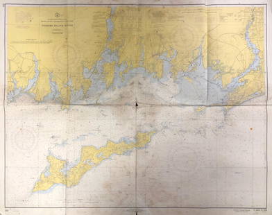
Sold2020Land Ho! Antique Fishers Island Sound, RI-CT-NY USCGDescription: Ahoy! Antique Coast Guard nautical chart of Fishers Island Sound, RI-CT-NY. Numbered C. & G. S. 358; published 1968. Material: paper. Measurement: approximate 36" x 45" (INCHES). ShippingSee Sold Price
Sold2019Land Ho! Antique Western L.I. Sound, CT U.S. CoastDescription: Ahoy! Antique Coast Guard nautical chart of the L.I. Sound. Numbered C. & G. S. 1213; printed in 1968. Material: paper. Measurement: approximate 34" x 40" (INCHES). Shipping cost: $10; diSee Sold Price
May 30Weatherham Estate TreasuresFloor Standing Antique Copper with Leather Griffith Astro Telescope 65"$800