Sold2019Five Hand Colored Maps by Handy, "The Second Map ofFive Hand Colored Maps by Handy, "The Second Map of England, North Umbria, Cumberlandia Et Dunelmensis (w/ history);" "The Third Map of England (w/ History};" "The Fifth Map of England (w/History);" "See Sold Price
Sold202117th C. Map of Virginia: Nova Virginia TabulaImportant hand colored early map, the second state of the first published map made after John Smith's map of the area around the Chesapeake Bay. Notable in part for its vignettes showing Native AmericSee Sold Price
Sold2022Early Hand Colored Maps Depicting the AmericasOne by Pieter Vander, circa 1707, the Magellan period. This map was used to illustrate the Dutch translations of the travel account of Diego Lopez de Sequeira. The second map, pulled from a book on laSee Sold Price
Sold2023GROUP OF 5 HAND COLORED MAPS OF THE AMERICASGroups of five hand colored antique maps of the Americas, comprising "America Merioio-Nalis (South American)" circa 1620, "Tabula Magellanica Qua Tierre Del Fuego (Strait of Magellan)" circa 1640, "IlSee Sold Price
Sold2016Lot of Five(5) Hand Colored MapsFive(5)hand colored maps; 12in. X 16in.(approx. image size), 16in. X 22in.(paper size)Please note: the number of maps has changedSee Sold Price
Sold20221836 Map of 25 Miles Round The City Of New-York.Historic Maps 1836 "Map of the Country Twenty Five Miles Round The City Of New-York." Published by D.S. Stone November 11, 1836-Dated, Hand-Colored Map titled, "Map of the Country Twenty Five Miles RoSee Sold Price
Sold2022MAP OF BRITISH & FRENCH SETTLEMENTS IN N. AMERICAby John Hinton London, University Magazine. 1755. 13 x 15 inches Together with a fragment of a second map of North America by J. Hinton. each printed on laid paper and hand colored Condition: Tear toSee Sold Price
Sold2021[Maps & Atlases] Janssonius, Johannes Nova Belgica et[Maps & Atlases] Janssonius, Johannes Nova Belgica et Anglia Nova Amstelodami: Johannes Janssonius, (1652). 19 1/8 x 22 1/2 in. (486 x 571 mm). Second state. Hand-colored engraved map depicting the eaSee Sold Price
Sold2021Lapham, I. A140. Lapham, I. A.Wisconsin: Its Geography and Topography...Second Edition, Greatly Improved. Folding hand-colored map. 8vo, contemporary sheep; cloth reback, endpapers renewed, generally sound internSee Sold Price
Sold20241835 Visible Heavens in April, May and June, E. H. BurrittGreat hand-colored map of the visible constellations in the second quarter of the year by Elijah H. Burritt. These are from Burritt’s 1835 edition of his atlas which, due to the rarity of the 18See Sold Price
Sold20231835 Visible Heavens in April, May and June, E. H. BurrittGreat hand-colored map of the visible constellations in the second quarter of the year by Elijah H. Burritt. These are from Burritt’s 1835 edition of his atlas which, due to the rarity of the 1See Sold Price
Sold2020Grp: 5 Maps of Germany Europe and the MediterraneGroup of five 18th century maps. This group includes a hand colored map of Germany by Herman Moll (ca. 1654-1732); one map of the Turkish empire by Tobias Conrad Lotter (1717-1777); one map of the BriSee Sold Price
Sold202316th CENTURY MAP of ARMENIA BLACK & CASPAN SEA REGION by PTOLEMY ANTIQUEWOOD ENGRAVED HAND COLORED MAP of ARMENIA , BLACK & CASPAN SEA REGION from DELLA GEOGRAFIA DI TOLOMEO c. second half of 16th century Overall size 9 by 12 1/4" Very good condition Reserve: $104.00 ShipSee Sold Price
Sold2019Modern Atlas Of 14 Maps-1826,14 hand colored fldg mapsTitle: Modern Atlas Of 14 Maps-1826,14 hand colored fldg maps Provenance: By Hart, Joseph C. About this Item: R. Lockwood, New York, 1826. Hardcover. Condition: VG. Second Edition. Very rare in this cSee Sold Price
Sold2023Civil War era map of Florida, 1863Lovely early map of Florida, vividly hand colored by county, with a large inset of the Florida Keys. Shows towns, railroads, villages, post offices, forts, etc. Only five counties shown in the southerSee Sold Price
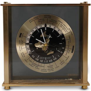
Sold2020Seiko World Desk ClockDESCRIPTION: A Seiko desk clock. Features a world map dial with white colored hands and airplane motif seconds hand. Marked "Seiko, Quartz Japan" Finished with time zone markers and a gilt brass case.See Sold Price
Sold2021A GEORGE II MAP OF AMERICA, "Recens Edita Totius NoviA GEORGE II MAP OF AMERICA, "Recens Edita Totius Novi Belgii, in America Septentrionali," SECOND STATE, AUGSBURG, 1730-1762, hand-colored engraving on paper watermarked, "N Milano Amalfi," and with anSee Sold Price
Sold2022Map of "The State of Massachusetts from the Best Information 1796"Map of "The State of Massachusetts from the Best Information 1796," hand colored copper engraving, published by J. Reid, New York from John Reid's American Atlas the second folio-sized atlas publishedSee Sold Price
Sold20231778 J. Lodge Exact Map of the Five Great Lakes1778 Lodge Exact Map of the Five Great Lakes with Part of Pensilvania New York, Canada and Hudson's Bay Territories from the best Surveys. Hand colored, fine framed acid free mount example. 8 1/2 by 1See Sold Price
Sold2019Five Maps: consisting of two copies of Johnson & Ward,Five Maps: consisting of two copies of Johnson & Ward, "Lower and Upper Canada," 1860-1863, hand colored, H.- 26 1/2 in., W.- 18 1/8 in.; together with two copies of Johnson & Ward, "Lower Canada & NeSee Sold Price
Sold2021Pair of Hand-Colored Engraved French Maps,M. VuilleminPair of French Maps, Haute-Vienne (Plate 87) and Ardeche (Plate 6), From FRANCE AND ITS COLONIES: ILLUSTRATED ATLAS OF ONE HUNDRED FIVE COLORED PLATES by M. Vuillemin | Edited / Published: Edité parSee Sold Price
Sold2024Early Map of North AmericaMap of North America Hand Colored Map. Map showing the Mexico when it contained California and Texas, as well as the United States claim on the west coast stretching to meet the Russian Possessions ofSee Sold Price
Sold2021Two Antique Hand-Colored MapsTwo Antique Hand-Colored Maps , incl. map of "La Hongrie..." by de Fer, 1717, 9 in. x 12 3/4 in., and "Romani Imperii/Mago", ND, 7 in. x 9 inSee Sold Price
Sold202319th C Hand Colored Map of State of Maine FRAMEDPublished by S.Augustus Mitchell, Jr. having a published date year of 1860. This hand colored map contains maps of the various countries of the world and plans of cities. Inset at lower right featuresSee Sold Price
5 days LeftTrillium Antique Prints & Rare BooksCatesby, Folio - Kingfisher with Narrow Leaved Candleberry Myrtle. 1-69$200
5 days LeftTrillium Antique Prints & Rare BooksHamilton - Pair of Engravings of a Painting from a Grecian Vase$100
5 days LeftTrillium Antique Prints & Rare BooksHamilton - Pair of Engravings of a Painting from a Grecian Vase$100
5 days LeftTrillium Antique Prints & Rare BooksCatesby, Folio - Great Laurel & Narrow Leaved Laurel. Sup-17$200
5 days LeftTrillium Antique Prints & Rare BooksCatesby, Folio - Plumeria Flore Niveo (White Frangipanni). 2-93$200
5 days LeftTrillium Antique Prints & Rare BooksDiggles, Australia - Laughing Jackass or Great Brown Kingfisher$75
5 days LeftTrillium Antique Prints & Rare BooksCatesby, Folio - Chain Snake with Climbing Hydrangea. 2-52$200


![[Maps & Atlases] Janssonius, Johannes Nova Belgica et: [Maps & Atlases] Janssonius, Johannes Nova Belgica et Anglia Nova Amstelodami: Johannes Janssonius, (1652). 19 1/8 x 22 1/2 in. (486 x 571 mm). Second state. Hand-colored engraved map depicting the ea](https://p1.liveauctioneers.com/65/217114/111330065_1_x.jpg?height=310&quality=70&version=1630684451)