Sold2022Scarce Hardesty map of Southwest US, 1875Great map of the West, noting copper, silver and gold regions throughout southern Arizona and New Mexico. “Map of Colorado, Utah, New Mexico and Arizona,” by J. David Williams. Published 1875 by HSee Sold Price
Sold2018Transitional western states with Gadsden Terr. – 1860sReserve Reduced! Great map of the West, naming Gadsden Territory as a separate region before it’s named Arizona. Map was issued shortly after the formation of Arizona, Nevada and Wyoming, each of whSee Sold Price
Sold2023Fur Country of the Far West Map by Hafen [161295]Red and black Fur Country of the Far West map by Leroy Hafen. A great map of the early West with historical detail. Hafen was born in Nevada in 1893 and died in 1985 in Palm Desert. He was a historianSee Sold Price
Sold2022Scarce 1856 Map of Great West, still in bookScarce and fascinating early map of the Plains, Midwest and Rocky Mountains, drawn by E.F. Beadle and published by Miller, Orton & Mulligan in “The States and Territories of the Great West.&rdquSee Sold Price
Sold20235 Of 7 Maps From 1846 Preuss & Fremont Oregon Trail ExpeditionJ.C. Fremont and Charles Preuss "Topographical Map of the Road from Missouri to Oregon in VII Sections" (Washington, by order of the Senate, printed in Baltimore by E. Weber, 1846). Seven maps were prSee Sold Price
Sold2022La Salle - Discovery of the West - Francis ParkmanLa Salle and the Discovery of the Great West Fold-out Map Present. Author: Francis Parkman Dated: 1899 Publisher: Little Brown Size: 8vo<See Sold Price
Sold2021Johnson map of American West – great color, 1864Authentic vintage maps of the American West—especially during the years of constant boundary change--are extremely collectible. Exceptional examples with great color and crisp ink impressions arSee Sold Price
Sold20191846 Quin Map of The Empire Of Alexander the Great --Title/Content of Map: 1846 Quin Map of The Empire Of Alexander the Great -- Fifth period : B.C. 323. The Empire Of Alexander Cartographer: E QuinDate: 1846, London Size: 13.2 X 20.3 in. This is a rareSee Sold Price
Sold2017SDUK: Antique Map of US Gulf Coast, 1846Title/Content of Map: 'NORTH AMERICA, SHEET XIII., Parts of Louisiana, Arkansas, Mississippi, Alabama & Florida' Native American settlements are named on the map west of the Mississippi, some marked wSee Sold Price
Sold2017Burgess: Antique Map of the United States & Canada 1853Map of the United States and Canada, Burgess 1853. Great map of the U. S. during the transitional period of the American West. Most of the western lands are shown as large territories: Minnesota, NebrSee Sold Price
Sold2017Map of West Virginia coal field 1867Heading: Author: Swann, John S. Title: Title Map of the Coal Field of the Great Kanawha Valley, West Virginia, United States of America Place Published: New York Publisher:G.W. Colton & C.B. Colton &See Sold Price
Sold2022BOOKS ON WORLD TRAVELERS AND ADVENTURERSOur New Way Round the World by Coffin, Boston, Fields 1869, Expedition to Borneo by Keppel New York, Harper 1846, (map), Letters from the West Indies b y Hovey, New York, Gould and Newman 1838, SailorSee Sold Price
Sold2021Scarce 1847 map of Western Terr. Of the U. S.Title: Scarce 1847 map of Western Terr. Of the U. S. Description: Great and uncommon map showing the transitional boundaries of the American West c1840s. massive Oregon Territory, encompassing futureSee Sold Price
Sold2023HOLY ROMAN EMPIRE. Europe. Otto the Great 962. Spread of Christianity 1902 mapTITLE/CONTENT OF MAP: 'Europe at the time of the Restoration of The Empire in the West by Otto the Great 962; Inset map of Spread of Christianity about the year 1000' DATE PRINTED: 1902 IMAGE SIZE: ApSee Sold Price
Sold2024HOLY ROMAN EMPIRE. Europe. Otto the Great 962. Spread of Christianity 1902 mapTITLE/CONTENT OF MAP: 'Europe at the time of the Restoration of The Empire in the West by Otto the Great 962; Inset map of Spread of Christianity about the year 1000' DATE PRINTED: 1902 IMAGE SIZE: ApSee Sold Price
Sold20186V Civil War Native Americans ANTIQUE AMERICAN HISTORY6V Civil War Native Americans ANTIQUE AMERICAN HISTORY United States West Decorative Maps Leather Bound Navy Blockade Cruisers Hunting Sports Adventures Celebrated Hunters Trappers Great Rebellion TraSee Sold Price
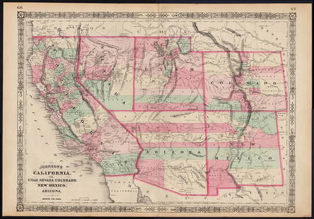
Sold2022Scarce Johnson map of the Great Western states, 1864Antique map of California, Nevada, Utah, Colorado, New Mexico, and Arizona. Published during a great time of expansion and change in the U.S. West, as well as during the Civil War. Here Utah displaysSee Sold Price
Sold20231873 Map of the Great PlainsStrinking map of the Western United States, primarily illustrating the various regions and mountain systems West of the Mississippi River. ca. 1873See Sold Price
Sold20221846 1ed Annals of the West American Revolution INDIANS Frontier Warfare MAPS1846 1ed Annals of the West American Revolution INDIANS Frontier Warfare MAPS Annals of the West is a rare, pre-Civil War account of various wars and battles fought on the American frontier during theSee Sold Price
Sold2022Western Travel notices 1800's: GN, C&GN, CB&Q4 advertising pieces of paper from the American West. All are 1800s and none are dated. Great Northern cardstock card with map and immigration info, MoPac - folding "Settlers" Excursion schedules andSee Sold Price
Sold2023Seutter - Map of North America including Great Lakes, Florida, Virginia, New England, Mexico, WestThis engraving is from a composite atlas presented by the Homann Heirs. Many of the maps in the collection were completed by J. B. Homann, Homann Erben, M. Seutter, and T. C. Lotter. The maps were oriSee Sold Price
Sold2020Brockhaus (Pub) 1890's Mixed Lot of 9 MapsIncl West Indies, America Continent, USA, Alexander The Great, Asia, and Middle East. Lithograph Maps 1892-98 by F. A. Brockhaus, Leipzig for "Brockhaus' Konversations-Lexikon" by Various. Centre foldSee Sold Price
Sold2018West Shore Railroad Timetable and 1888 Booklet2 paper items from the New York West Shore & Buffalo Railroad: (1) undated folding timetable - tape repairs - just fair condition (2) great condition 1888 book with fold out map. - fine condition.See Sold Price
Sold20231845 Fremont Map of the Bear River, the Major Tributary to the Great Salt Lake [with] Bear SpringsTitle: 1845 Fremont Map of the Bear River, the Major Tributary to the Great Salt Lake [with] Bear Springs Cartographer: J. C. Fremont Year / Place: 1845, Washington Map Dimension (in.): 8.9 X 18 in. lSee Sold Price
2 days LeftJasper52Grand Bahama & Great Abaco Islands. Bahamas. ADMIRALTY sea chart 1886 (1968) map$140
2 days LeftJasper52Bahamas harbours Pelican Abaco Berry I Jumentos ADMIRALTY chart 1899 (1920) map$140
1 day LeftJasper521720 Strype Ward Map of Eastern portions of City of London -- Langborne Ward ? [on sheet with]$80
2 days LeftJasper52The Consolidated Slave Act of Jamaica 1792. 40 pages. Bryan Edwards 1794 print$120
5 days LeftTrillium Antique Prints & Rare BooksDavid Roberts - Fragments of the Great Colossi, at the Memnonium$200
Featured2 days LeftJasper52BARBADOS. Vintage map. West Indies Caribbean 1923 old antique plan chart$50


![Fur Country of the Far West Map by Hafen [161295]: Red and black Fur Country of the Far West map by Leroy Hafen. A great map of the early West with historical detail. Hafen was born in Nevada in 1893 and died in 1985 in Palm Desert. He was a historian](https://p1.liveauctioneers.com/2699/291514/154451414_1_x.jpg?height=310&quality=70&version=1685892555)


![1845 Fremont Map of the Bear River, the Major Tributary to the Great Salt Lake [with] Bear Springs: Title: 1845 Fremont Map of the Bear River, the Major Tributary to the Great Salt Lake [with] Bear Springs Cartographer: J. C. Fremont Year / Place: 1845, Washington Map Dimension (in.): 8.9 X 18 in. l](https://p1.liveauctioneers.com/5584/300214/159930791_1_x.jpg?height=310&quality=70&version=1693338270)


![1720 Strype Ward Map of Eastern portions of City of London -- Langborne Ward ? [on sheet with] (1 of 1)](https://p1.liveauctioneers.com/5584/327462/176400787_1_x.jpg?height=282&quality=70&version=1714507756)


