Sold2021Antique Map ETHNOGRAPHISCHE KARTE VON EUROPA, J. MeyerAntique Map ETHNOGRAPHISCHE KARTE VON EUROPA (German)(Translated: Ethnographic Map of Europe), Joseph Meyer (1796-1856) | Map shows the various races/peoples as they are spread throughout Europe. ThisSee Sold Price
Sold20182 Maps incl: Rudolf Gross. Karte Der Schweiz. 1865[Pocket Maps] 2 Maps. ++ Dr. A. Petermann’s Karte Von Europa Und Dem Mittellandischen Meere. Gotha: Justus Perthes, 1867. 16 sections on orig linen backing, each 10 1/2 x 8 1/2 in. Loose as issued iSee Sold Price
Sold2019Heinrich Roberts, "Karte von den N.W, Amerikanschen undHeinrich Roberts, "Karte von den N.W, Amerikanschen und N.OE. Asiatischen Kusten. Capt. Cook," 1778-1788, hand colored, H. - 18 in., W. - 29 1/2 in.See Sold Price
Sold2022Reymann, Gottlob Daniel (Topographische Special-Karte von Central Europa). Fortgesetzt von CarlAtlanten Reymann, Gottlob Daniel (Topographische Special-Karte von Central Europa). Fortgesetzt von Carl Wilhelm von Oesfeld und Friedrich Handtke. 7 Bde. Mit 300 (wohl von 342) tls. grenzkoloriertenSee Sold Price
Sold2023Map of the Turkish Empire in Europe by J. Walch - 1812 engravingMap of the Turkish Empire in Europe. Title: Karte von dem Türkischen Reiche in Europa Engraver and cartographer: Johannes Walch (25 November, 1757 - 23 March, 1815). Description: handcolored engrSee Sold Price
Sold2019Rare 1st ed./1st state decorative map, 1848From the first comprehensive physical atlas of the world. This map comes from the rare first edition/first state of “Physikalischer Atlas oder Sammlung von Karten” by Heinrich Berghaus. Full titleSee Sold Price
Sold2020Angeli, Heinrich von: Kaiserin Elisabeth (?)Heinrich von Angeli 1840 - 1925 Empress Elisabeth (?) Oil on canvas, relined; H 55 cm, W 46 cm; signed lower right ''HvAngeli''See Sold Price
Sold2022HEINRICH VON RUSTIGE , OIL ON CANVAS BATTLE SCENEHeinrich Franz Gaudenz von Rustige (GERMAN, 1810-1900) 19thC OIL ON CANVAS PRUSSIAN BATTLE SCENE DEPICTING KING OTTO DURING CRIMEAN WAR (KING OTTO OF GREECE , BAVARIAN PRINCE Otto Friedrich Ludwig vonSee Sold Price
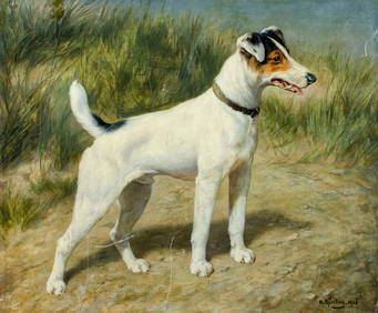
Sold2023Johann Heinrich von Zugel, 1950-1941 Germany / Netherlands] Pig and Piglets in Barn StableJohann Heinrich von Zugel, 1950-1941 Germany / Netherlands] Pig and Piglets in Barn Stable, Oil on Canvas Painting, Framed. size: 24 x 36, 30 x 42 outside frame. ASKart: Johann Heinrich Von Zugel (185See Sold Price
Sold2022HEINRICH VON ANGELI BILDNIS EINER JUNGEN DAME (1870)HEINRICH VON ANGELI 1840 OEdenburg - 1925 Hungary Portrait of a young lady (1870) Oil on wood. 65 x 54 cm (F. 97 x 87 cm). Signed and dated on the right 'H. von Angeli 1870'. Part. min. rest. Frame. PSee Sold Price
Sold2023Palastina Album of the Holy Land, Gotthilf Heinrich von Schubert, Stuttgart, 1868.Palastina Album of the Holy Land, Gotthilf Heinrich von Schubert, Stuttgart, 1868. 50 views of important places mentioned in scripture, drawn from nature by J.M. Bernatz, and G.H. v. Schubert, J. RothSee Sold Price
Sold2019Karte Von Grossbritannien Und Ireland.Title/Content of Map: Karte Von Grossbritannien Und Ireland. Date: 1795 Cartographer: REILLY, FRANZ JOHANN JOSEPH VON (1766-1820) Publisher: REILLY'SCHEN LANDKARTEN UND KUNSTWERKE VERSCHIESS KOMPTOIRSee Sold Price
Sold2023After Johann Heinrich Von Dannecker, (1758-1841, German), "Bust of a Gentleman," 19th c., patinatedAfter Johann Heinrich Von Dannecker, (1758-1841, German), "Bust of a Gentleman," 19th c., patinated bronze, on a bronze mounted green onyx column on a square plinth, H.- 7 1.4 in., W.- 2 1/4 in., D.-See Sold Price
Sold2022Heinrich von Schwarzenfeld German, 20th Century City in the Rain, Twilight, 1962Heinrich von Schwarzenfeld German, 20th Century City in the Rain, Twilight, 1962 Signed H. v. Schwarzenfeld and dated 1962 (ll) Oil on canvas 20 1/4 x 28 1/4 inches (51.4 x 71.8 cm) CSee Sold Price
Sold2022after Johann Heinrich Von Dannecker, 19th C. Parian Porcelain Adriadne on the Pantherafter Johann Heinrich Von Dannecker, 19th C. Parian Porcelain Adriadne on the Panther. size: 8.75h 6.75w. ASKart: Johann Heinrich Dannecker (1758 - 1841) was active/lived in Germany. Johann DanneckerSee Sold Price
Sold2022Vintage Nautical Map: Karte von dem Abendlændischen OceanVintage Nautical Map: Karte von dem Abendlændischen Ocean. size: 13 x 18 matte, 18 x 22 outside frame. Google: Nautical chart of North Atlantic Ocean with portions of North and South America, SouthSee Sold Price
Sold2019German, "Neueste Karte von Louisiana," 1845, with anGerman, "Neueste Karte von Louisiana," 1845, with an inset of New Orleans, H.- 14 1/2 in., W.- 18 in.See Sold Price
Sold2019Franz Joseph Von Reilly (1766-1820), "Karte von AmericaFranz Joseph Von Reilly (1766-1820), "Karte von America nach D'Anville and Pownall, 1756 (Inset) Karte von der Republik Der Vereinigten Dreyzehn Staten In Nord America, 1777," H. - 24 in., W. - 31 in.See Sold Price
Sold20181845 Meyer Map of Tennessee -- Neueste Karte vonReserve Reduced! Title/Content of Map: 1845 Meyer Map of Tennessee -- Neueste Karte von Tennessee nach den Bessten Quellen Verbessert 1849 Date: 1845, Hildburghausen Cartographer: J Meyer Size: 11.6 XSee Sold Price
Sold2023Automobilia Badge 'Grosser Preis von Europa Nürburgring 195Enameled (Laufer Nuremberg), 10x7cmSee Sold Price
Sold20211849 Meyer Map of Tennessee -- Neueste Karte vonTitle: 1849 Meyer Map of Tennessee -- Neueste Karte von Tennessee nach den Bessten Quellen Verbessert 1849 Cartographer: J Meyer Year / Place: 1849, Leipzig Map Dimension (in.): 12 X 15 in. Elegant anSee Sold Price
Sold20231818 Walch Map of India and Southeast Asia -- Karte von OstindienTitle: 1818 Walch Map of India and Southeast Asia -- Karte von Ostindien Cartographer: J Walch Year / Place: 1818, Augusburg Map Dimension (in.): 7.5 X 8.8 in. This is a very nice map of Southeast AsiSee Sold Price
Sold20231818 Walch Map of Asia -- Karte von AsienTitle: 1818 Walch Map of Asia -- Karte von Asien Cartographer: J Walch Year / Place: 1818, Augusburg Map Dimension (in.): 7.5 X 9 in. This is a rather nice continental map of Asia. Much detail is offeSee Sold Price
Sold2017Neueste Karte von Australien, 1846Map: Neueste Karte von Australien Cartographer: Bibliographischen Instituts. Place & Date: Hildburghausen / 1846 Size: 11 3/4" x 14 5/8" The superbly detailed map of Oceania and the Pacific from MeyerSee Sold Price
7 days LeftFichter KunsthandelF. HOHE (*1802) after HESS (*1798), Farewell to St Boniface, 1843, Lithography€900
2 days LeftHermann Historica GmbHGeneral August Graf Neidhardt von Gneisenau (1760 - 1831) – the sword of PLM bearer Oberst€4,000
BonhamsHERTZ ON HIS MENTOR HERMANN VON HELMHOLTZ. HERTZ, HEINRICH. 1857-1894. Autograph Manuscript, a h...$16,000
6 days LeftAuction Team BrekerRare "Sternen-Brauerei Schkeuditz G.m.b.H." Raum­bild Album, c. 1939€500
5 days LeftHermann Historica GmbHHermann Göring - a handwritten letter from Nuremberg to his wife Emmy, winter 1945/46€600
5 days LeftHermann Historica GmbH"Operation Chariot" - a military map of the 22nd Naval Flak Regiment, March 27/28, 1942€720
May 14Hermann Historica GmbHProf. Victor Heinrich Seifert (1870 - 1953) - a large knight figure€1,400
May 14Hermann Historica GmbHA porcelain figure showing "Europe on the Bull", Adolph Amberg, 1909 (design), KPM, 20th century€480
5 days LeftHermann Historica GmbHKarl Diebitsch - a large format oil painting on canvas "Woman in Bavarian Dress"€950
5 days LeftHermann Historica GmbHA war diary from the 4th Artillery Carrier Flotilla, April 1 to July 31, 1944€720
May 14Hermann Historica GmbHA Chinese frog-shaped pouring vessel (kendi), probably early Qing Dynasty€800
10 hrs LeftBroward Auction GalleryHeinrich Sperling (German,1844-1924) oil painting antique$2,700(8 bids)
10 hrs LeftBroward Auction GalleryHeinrich Hirt (German,1841-1902) oil painting antique$3,300(9 bids)


![2 Maps incl: Rudolf Gross. Karte Der Schweiz. 1865: [Pocket Maps] 2 Maps. ++ Dr. A. Petermann’s Karte Von Europa Und Dem Mittellandischen Meere. Gotha: Justus Perthes, 1867. 16 sections on orig linen backing, each 10 1/2 x 8 1/2 in. Loose as issued i](https://p1.liveauctioneers.com/179/117971/60557787_1_x.jpg?height=310&quality=70&version=1520636872)


![Johann Heinrich von Zugel, 1950-1941 Germany / Netherlands] Pig and Piglets in Barn Stable: Johann Heinrich von Zugel, 1950-1941 Germany / Netherlands] Pig and Piglets in Barn Stable, Oil on Canvas Painting, Framed. size: 24 x 36, 30 x 42 outside frame. ASKart: Johann Heinrich Von Zugel (185](https://p1.liveauctioneers.com/3627/296255/157434458_1_x.jpg?height=310&quality=70&version=1690653896)