Sold2020Herman Moll Emanuel Bowen "A Complete System of GHerman Moll (ca. 1654-1732) and Emanuel Bowen (1694-1767), "A Complete System of Geography," London, 1747. Volumes I and II. The title page reads: "A Complete System of Geography. Being a DescriptionSee Sold Price
Sold2016Map, of the Netherlands Circa 1734Description: Map of "The Austrian and French Netherlands attributed to Emanuel Bowen and Herman Moll. History: Moll produced his earliest maps from studying cartographers such as John Senex and EmanueSee Sold Price
Sold2017Two Emanuel Bowen Maps Showing the East Coastfrom A Complete System of Geography (London, 1747), copperplate engravings with outline color as follows: A New and Accurate Map of New Jersey, Pennsylvania, New York and New England and A New & AccurSee Sold Price
Sold2017Emanuel Bowen Map of Mexico and Central Americacopperplate engraving with outline color, A New & Accurate Map of Mexico or New Spain together with California New Mexico &c., from A Complete System of Geography (London, 1747), with inset map of theSee Sold Price
Sold20191747 Engraved map of Asia by Emanuel Bowen1747 Engraved map of Asia by Emanuel Bowen "A New & Accurate Map of Asia", from 'A Complete System of Geography' (London: for William Innys, Richard Ware, etc, 1747), in fine contemporary hand color,See Sold Price
Sold2022A leather bound Book A complete history of England dated 1706 together with A complete system of GeoA leather bound Book A complete history of England dated 1706 together with A complete system of Geography dated 1747 published by Herman Moll.See Sold Price
Sold2020West Indies. Spanish galleons routes map.Title: West Indies. Spanish galleons routes map. Date/Period: 1744-1748. Materials: Copperplate engraved Dimensions: 19x16 1/4” By Emanuel Bowen. From, John Harris’s A Complete Collection of voyagSee Sold Price
Sold2020Galápagos IslandsTitle: Galápagos Islands Description: By Emanuel Bowen. From. John Harris’s A complete collection of voyages and travels. Published. London. One of the earliest obtainable maps of just the GalápagSee Sold Price
Sold2020Marco Polo’s travels mapTitle: Marco Polo’s travels map Date/Period: 1744-1748. Materials: Copperplate engraved Dimensions: 9 3/4 x 16” By Emanuel Bowen. From. John Harris’s A complete collection of voyages and travelsSee Sold Price
Sold2020AfricaTitle: Africa Date/Period: 1744-1748 Materials: Copperplate engraved Dimensions: 19 x 16 1/4”. By Emanuel Bowen. From John Harris’s a Complete Collection of voyages and travels. Published, LondonSee Sold Price
Sold2020GreeceTitle: Greece Date/Period: 1744-1748 Materials: Copperplate engraved. Size: 16 x 9 3/4 “ Description: By.Emanuel Bowen. From. John Harris’s a Complete Collection of voyages and travels. Published.See Sold Price
Sold202018th c. Map of America- Emanuel Bowen18th c. Map- ''A New and Accurate Map of America''- engraved map, 1748, from John Harris- ''Complete Collection of Voyages and Travels'', short repaired separation at top of centerfold. 14 3/8 x 17 5/See Sold Price
Sold2023Scarce 1701 Herman Moll map of Palestine (1st ed.)“Canaan, Palestine or the Holy Land &c divided into twelve Tribes of Israel,” from Herman Moll’s “A System of Geography,” published 1701. Many place names and individualSee Sold Price
Sold2023Scarce and fine 1701 1st ed. map of Italy by Herman MollExcellent example of Moll’s 1701 map of Italy from the first edition of “A System of Geography.” A very scarce map with expertly applied modern full hand coloring according to politSee Sold Price
Sold2020Southern India.Title: Southern India. Description: 1744-1748 map by Emanuel Bowen, published by John Harris in Navigantium Atque Itinerantium Bibliotheca', or a Complete Collection of Voyages and Travels. London. AuSee Sold Price
Sold2020Ancient western India. Today’s Afghanistan & PakistanTitle: Ancient western India. Today’s Afghanistan & Pakistan Description: Map by Emanuel Bowen, published by John Harris in 'Navigantium Atque Itinerantium Bibliotheca' or a Complete Collection of VSee Sold Price
Sold2019COOKE (G A) Modern and Authentic System of UniversalCOOKE (G A) Modern and Authentic System of Universal Geography...forming a Complete Collection of Voyages and Travels... Complete Atlas, no date, c.1800, 4to, 24 folding maps, plates with some typicalSee Sold Price
Sold2022BEAVER MAP, HERMAN MOLL (DUTCH/BRITISH, 1654-1732)A New and Exact Map of the Dominions of the King of Great Britain on ye Continent of North America containing Newfoundland, New Scotland, New England, New York, New Jersey, Pensilvania, Maryland, VirgSee Sold Price
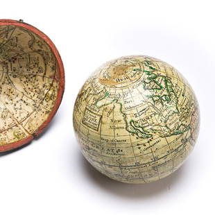
Sold2023(GLOBES.) Style of Herman Moll. A Correct Globe with the New Discoveries.(GLOBES.) Style of Herman Moll. A Correct Globe with the New Discoveries. 2¾-inch miniature terrestrial pocket globe comprised of 12 hand-colored engraved gores and 2 polar calottes on a plasterSee Sold Price
Sold2024Map of the North Parts of America Claimed by France by Herman Moll (London, 1720)Map of the North Parts of America Claimed by France by Herman Moll (London, 1720) "A New Map of the North Parts of America claimed by France under ye Names of Louisiana, Mississippi, Canada, and New FSee Sold Price
Sold2017FRAMED WORLD MAP BY HERMAN MOLL, 1719'A New & Correct Map of the Whole World, by Herman Moll, Geographer, 1719.' Hand tinted and framed. Frame size: 73 x 124 cm (28 3/4 x 48 3/4 in.)See Sold Price
Sold2019Herman Moll 1654-1732), "A New And Correct Map of theHerman Moll 1654-1732), "A New And Correct Map of the World," 1710, hand colored, H. - 22 in., W. - 38 in.See Sold Price
Sold20241766 Emanuel Bowen "The Maps And Charts Of The Modern Part Of The Universal History"Printed for T. Osborne, A. Millar, J Rivington, B. Law And Co., T. Longman, C. Ware, and S. BladonSee Sold Price
Sold2019Two Copies of Emanuel Bowen (1693-1767), "A New Map ofTwo Copies of Emanuel Bowen (1693-1767), "A New Map of Georgia, Florida, Louisiana, Carolina," 1748, H.- 15 3/4 in., W.- 20 in.See Sold Price
May 10Hermann Historica GmbHAn "Enigma G" cipher machine from the German Intelligence Service (Abwehr), number "G 193", complete€90,000(1 bid)