Sold2022[ARTHUR H. CLARK COMPANY] -- [WESTERN AMERICANA]. A group of 7 works   in 7 volumes, most[ARTHUR H. CLARK COMPANY] -- [WESTERN AMERICANA]. A group of 7 works, comprising: MORGAN, Dale Lowell, and Carl I. WHEAT. Jedediah Smith and his Maps of the American West. SF, 1954. LIMITED EDITION, nSee Sold Price
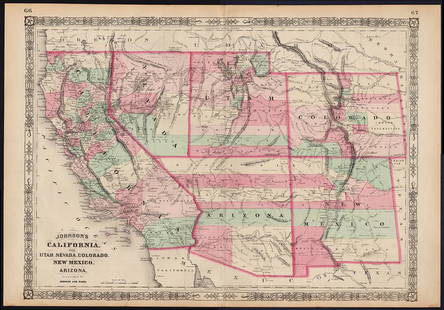
Sold2021Johnson map of American West – great color, 1864Authentic vintage maps of the American West—especially during the years of constant boundary change--are extremely collectible. Exceptional examples with great color and crisp ink impressions arSee Sold Price
Sold20211850 Calif. and Territories by CowperthwaitVery desirable and distinctive map of the American west, with Utah Territory and New Mexico Territory accounting for nearly half of the West. “A New Map of the State of California, the Territories oSee Sold Price
Sold2020Central America Caribbean Gulf of Mexico chart PortsTITLE/CONTENT OF MAP: 'Central American and West Indian Ports; Inset The Pacific Coast from San Diego to Vancouver; San Francisco; Aleutian; The Pacific Coast from Seattle to Dutch Harbor; Bermudas; KSee Sold Price
Sold2024Central America Caribbean Gulf of Mexico chart Ports lighthouses LARGE 1952 mapTITLE/CONTENT OF MAP: 'Central American and West Indian Ports inset The Lesser Antilles; The Windward Passage; Bermudas; Kingston; Havana; Salina Cruz; Coatzacoalcos; Willemstad, Curacao' DATE PRINTEDSee Sold Price
Sold2024Central America Caribbean Gulf of Mexico chart Ports lighthouses LARGE 1927 mapTITLE/CONTENT OF MAP: Central American and West Indian Ports [inset The Lesser Antilles; The Windward Passage; Bermudas; Kingston; Havana; Salina Cruz; Puerto Mexico; Mouths of the Mississippi] DATE PSee Sold Price
Sold2021Double Hemisphere world map by Bonne/ Raynal 1780Title: Double Hemisphere world map by Bonne/ Raynal 1780 Date/Period: 1780 Materials: Copperplate engraved Size: 17 1/2 x 9 3/4”. Maps shows the North American west empty, misshaped Alaska, theSee Sold Price
Sold20191874 1st ed Wonders of Yellowstone American West1874 1st ed Wonders of Yellowstone American West Illustrated MAPS National Parks James Richardson’s ‘Wonders of the Yellowstone Region’ is a finely illustrated work on the First American NationaSee Sold Price
Sold2022MITCHELL, S. AUGUSTUS. A New Map of Texas, Oregon and California.MITCHELL, S. AUGUSTUS. A New Map of Texas, Oregon and California. Engraved pocket map of the American territories west of the Mississippi River. 22¾x21 inches overall, ample margins; strong origiSee Sold Price
Sold2016Nova Virginia Tabula. [1671 or later].[Virginia] NOVA VIRGINIAE TABULA. Derived from the Hondius-Blaeu version of John Smith’s map. Oriented to the West. Tooley’s Derivative 8, State 1: Cartouche at upper left with no imprint. “NotaSee Sold Price
Sold2022Map of entire Western States, Steinwehr 1870Nice map depicts the entire American West from top to bottom of the country. Shows railroads, topography, rivers, forts, towns. Printed color. Map by A. von Steinwehr in 1870 atlas published by WilsonSee Sold Price
Sold20221796 John Reid American Map of the West Indies - by John Reid. AN ACCURATE MAP OF THE WEST INDIES1796 John Reid American Map of the West Indies - by John Reid. AN ACCURATE MAP OF THE WEST INDIES WITH THE ADJACENT COAST OF AMERICA. Engraved by D. Martin. Published in New York in "An American AtlasSee Sold Price
Sold2018Scarce 1853 Calif. & western states, CowperthwaitReserve Reduced! One of the important obtainable maps of California and the American west. Important depiction of the west at a time of dramatic change, both in terms of geographic discovery and politSee Sold Price
Sold20221895 1ed Yellowstone National Park American West Indian Explorer Illustrated MAP1895 1ed Yellowstone National Park American West Indian Explorer Illustrated MAP Hiram Chittendens The Yellowstone National Park is a finely illustrated work on the first American National Park. ThisSee Sold Price
Sold2020Jedediah Smith by Dale Morgan Signed 1st EditionJedediah Smith and the Opening of the West by Dale Morgan. Signed stated First Edition. Interior pages, covers and spine EX+/NrMt, dust jacket EX/EX+ Measures 8.75-in. x 6.25-in. Provenance: Bob BorchSee Sold Price
Sold20211870 1ed Life in Utah MORMON Polygamy Custer1870 1ed Life in Utah MORMON Polygamy Custer Little Bighorn INDIANS Beadle Map An important work of the American West – Mormon excursion, Native American Indians, and the defeat of Custer at LittleSee Sold Price
Sold20221846 1ed Annals of the West American Revolution INDIANS Frontier Warfare MAPS1846 1ed Annals of the West American Revolution INDIANS Frontier Warfare MAPS Annals of the West is a rare, pre-Civil War account of various wars and battles fought on the American frontier during theSee Sold Price
Sold2016Langdon Smith (American, 1870-1959), oil on canvas,Langdon Smith (American, 1870-1959), oil on canvas, The West Coast Magazine Cover, 1907, 20" x 15" stretcher, 25-1/2" x 20-3/4" overall , Property from the Estate of Daniel Dietrich, IISee Sold Price
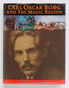
Sold2022''Carl Oscar Borg and the Magic RegionHelen Laird. ''Carl Oscar Borg and the Magic Region: Artist of the American West.'' First Edition. Gibbs M. Smith, Inc. 1986, Layton, UT. Hardbound with dust jacket.See Sold Price
Sold2021Scarce 1847 map of Western Terr. Of the U. S.Title: Scarce 1847 map of Western Terr. Of the U. S. Description: Great and uncommon map showing the transitional boundaries of the American West c1840s. massive Oregon Territory, encompassing futureSee Sold Price
Sold2023Charles William Smith, signed in the plate original woodcutArtist: Charles William Smith (American, 1893-1987) Title: A Charlston Window Year: 1933 Medium: original woodcut Image Size: 8.5 x 7.0 inches Sheet Size: 10.5 x 8.8 inches Catalog reSee Sold Price
Sold2021Isaac Smith American, 1944-2016 Group of Four AnimalsIsaac Smith American, 1944-2016 Group of Four Animals (Toad, Two Frogs and Lizard) Each signed Isaac Smith Enamel on wood Largest 7 1/4 x 11 x 8 1/2 inches C Estate of an Upper West Side CollectorSee Sold Price
Sold2020Jess B. Smith (American, 20th Century) God's CattleJess B. Smith (American, 20th Century) God's Cattle oil on board signed and titled (verso) 24 x 48 inches Property sold to benefit the Acquisitions Fund of the Buffalo Bill Center of the WestSee Sold Price
Sold2022Marvels of the American West, Iroquois Lore, etc. 12 vols.Thayer, William M. Marvels of the New West: A Vivid Portrayal of the stupendus Marvels in the vast Wonderland West of the Missouri River. Illustrated with over 359 engravings and maps. Norwich, Conn.:See Sold Price
3 days LeftAdam's AuctioneersH.C CAREY AND I.LEA (publishers) A Complete Historical, Chronological and Geographical AMERICAN€1,500(1 bid)
6 days LeftTrillium Antique Prints & Rare BooksCarey & Lea's .. American Atlas - Volume with 46 Originally Hand-colored Folio Maps$1,000(1 bid)


![[ARTHUR H. CLARK COMPANY] -- [WESTERN AMERICANA]. A group of 7 works   in 7 volumes, most: [ARTHUR H. CLARK COMPANY] -- [WESTERN AMERICANA]. A group of 7 works, comprising: MORGAN, Dale Lowell, and Carl I. WHEAT. Jedediah Smith and his Maps of the American West. SF, 1954. LIMITED EDITION, n](https://p1.liveauctioneers.com/197/264838/138100437_1_x.jpg?height=310&quality=70&version=1665664275)


![Central America Caribbean Gulf of Mexico chart Ports lighthouses LARGE 1927 map: TITLE/CONTENT OF MAP: Central American and West Indian Ports [inset The Lesser Antilles; The Windward Passage; Bermudas; Kingston; Havana; Salina Cruz; Puerto Mexico; Mouths of the Mississippi] DATE P](https://p1.liveauctioneers.com/5584/316569/169897699_1_x.jpg?height=310&quality=70&version=1706046386)


![Nova Virginia Tabula. [1671 or later].: [Virginia] NOVA VIRGINIAE TABULA. Derived from the Hondius-Blaeu version of John Smith’s map. Oriented to the West. Tooley’s Derivative 8, State 1: Cartouche at upper left with no imprint. “Nota](https://p1.liveauctioneers.com/179/93063/47518642_1_x.jpg?height=310&quality=70&version=1472482862)