Sold2024L' Asie. Asia Tartary China Mughal Empire. BUFFIER c1818 old antique map chartCAPTION PRINTED BELOW PICTURE: L' Asie [Asia] DATE PRINTED: c1818 IMAGE SIZE: Approx 14.0 x 18.0cm, 5.5 x 7 inches (Medium); Please note that this is a folding map. TYPE: Antique engraved map CONDITIOSee Sold Price
Sold2023L'America Meridionale. South America. DE ROSSI / SANSON 1677 old antique mapTitle: L'America Meridionale. South America. DE ROSSI / SANSON 1677 old antique map Description: L'America Meridionale [South America] by Published by Giovanni Giacomo de Rossi. G. Sansone, Giorgio WiSee Sold Price
Sold2023L'Africa. DE ROSSI / SANSON 1677 old antique vintage map plan chartTITLE/CONTENT OF MAP: L'Africa [Africa] DATE PRINTED: 1677 IMAGE SIZE: Approx 42.5 x 57.0cm, 16.75 x 22.25 inches (Large) TYPE: Antique 17th century folio atlas map CONDITION: Good; suitable for framiSee Sold Price
Sold2017Sanson-Rossi: Map of Asia with China & Korea, 1687L'ASIA. Asia Map with China and Korea by Sanson and Rossi (62 x 49 cm, 1687) Please note that this lot has a confidential reserve. When you leave a bid in advance of the auction, submit your maximum.See Sold Price
Sold2017Three maps of Africa and Middle Eastcomprising: 1) Nicolas Sanson, "Haute Ethiopie …" Paris, 1655, engraving, about 16 X 20 in., p.m.; 2) after Sanson, "Description de l'Empire du Sophi des Perses," Paris, c,1730, engraving with old oSee Sold Price
Sold2024L'Europa. Europe. DE ROSSI 1677 old antique vintage map plan chartTITLE/CONTENT OF MAP: L'Europa [Europe] DATE PRINTED: 1677 IMAGE SIZE: Approx 44.0 x 56.5cm, 17.25 x 22.25 inches (Large) TYPE: Antique 17th century folio atlas map CONDITION: Good; suitable for framiSee Sold Price
Sold2023MAP, China & Korea, BellinChina & Korea. Jacques Nicolas Bellin, L'Empire de la Chine pour Servir a l'Histoire Generale des Voyages, from Histoire Generale des Voyages, 1748 (dated). Hand Color. Attractive and detailed map ofSee Sold Price
Sold2016Map of China and Japan. Asia. 1837.Print of steel engraving titled „Chine et Japon“.Drawn by TH. Duvotenay.Engraved by unknown.From „Chine ou Description Historique, Geographique et Litteraire de ce vaste empire, d‘apres des doSee Sold Price
Sold2015A map of China, Korea and the Japanese Isles, ca. 1779SANTINI, Paolo, L'Empire de la Chine, avec la Tartarie Chinoise d'aprs l'Atlas Chinois. Venice, Remondini, 1779. Original outline colour. 485 x 560mm. China, Korea and Tartary, also showing Japan andSee Sold Price
Sold2024De Vaugondy map of ChinaHeading: (China) Author: Robert de Vaugondy, Gilles and Didier Title: L'Empire de la Chine dressé d'après les Cartes de l'Atlas Chinois Place Published: [Paris] Publisher: Date Published: 1See Sold Price
Sold20211796 Josephe de Laporte map of China1796 Josephe de LaPorte hand colored map "L'Empire de la Chine avec les Isles Du Japon et la Coree", sight 7 1/4" x 8 3/4", well framed, overall 12" x 14"See Sold Price
Sold2017Bellin: Antique Map of Tartary, Tibet, Silk-Road ChinaMap: Carte de l'Empire de Hya et Partie de Tangut Cartographer: Bellin Place & Date: Paris / 1749/1760 Size: 12 1/8" x 8 5/8" Condition: outline color; overall age toning, some minor spotting, and a lSee Sold Price
Sold2016CHINA-EMPIRE 1911 One Dollar Silver, NGC MS66CHINA-EMPIRE 1911 One Dollar Silver, Extra Flame, L&M37, Y31, NGC MS66. Highest graded coin by NGC. H.F.Bowker East Asia CollectionSee Sold Price
Sold2020Du Halde*** START PRICE IS THE RESERVE *** [Asia] DU HALDE, Jean Baptiste, S. J. (1674 - 1743). Description geographique, historique, chronologique, politique, et physique de l'Empire de la Chine et de la TarSee Sold Price
Sold2017Bellin: Map of L'Empire de la Chine, 1748L'Empire de la Chine. Bellin's superbly rendered map of the Empire of China and the Kingdom of Korea, with good topographical detail, many place names, and three elaborate cartouches, from Prevost d'ESee Sold Price
Sold2022GREAT TARTARY. 'Grande Tartarie'. Russia China N & Central Asia. MALLET 1683 mapTITLE OF THE MAP: 'Grande Tartarie' (De L'Asie) Tartary (Latin: Tartaria) or Great Tartary (Latin: Tartaria Magna) was a name used by Europeans from the Middle Ages until the twentieth century to desiSee Sold Price
Sold2016Sphere of Emperor Chun. China. 1837.Print of steel engraving titled „La Sphère de l'Empereur Chun“.Drawn by unknown.Engraved by unknown.From „Chine ou Description Historique, Geographique et Litteraire de ce vaste empire, d‘aprSee Sold Price
Sold2023MAP, Africa, Robert de VaugondyAfrica. Gilles Robert de Vaugondy, L'Afrique Divisee en ses Principaux Empires et Royaumes par les Srs. Sanson..., 1749 (dated). Hand Color. Gilles Robert de Vaugondy succeeded his uncle, Pierre MoulaSee Sold Price
Sold2020Nicolas Sanson Map of AsiaNicolas Sanson (1600-1667) "L'Asie divisee en ses Principales Regions, et ou se peuvent voir l'estendue, Des Empires, Monarchies, Royaumes, et Estats," Paris: Jaillot, ca. 1719. Hand colored map of AsSee Sold Price
Sold202119th C. Mughal Gold Pendant- White Topaz, Glass, RubiesSouth Asia, Northwestern India, Mughal Empire, ca. 19th century CE. This is a stunning Mughal pendant made of high-quality gold inlaid with green glass and Kundan stones of white topaz and rubies! TheSee Sold Price
Sold2024Indian Mughal Jade Holdali Pendant w/ Diamonds, GemsSouth Asia, Northern India, Rajasthan, Mughal Empire ca. 19th century CE. A spectacular jade Holdali pendant, the frontal face is inlaid with precious gemstones within high quality gold embellishmentsSee Sold Price
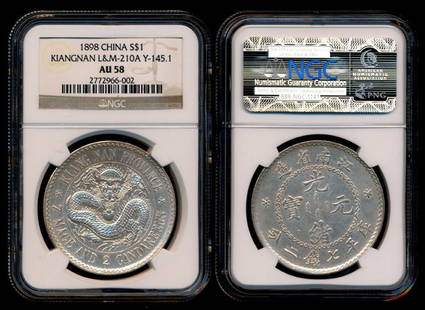
Sold2016China Empire Kiangnan $1 1898 NGC AU58China Empire, Kiangnan Province, Dollar, (Y.145.1; L&M-210A), 1898, NGC AU58.See Sold Price
Sold2022China Empire $1 1911 NGC XF45China Empire, General Issue, Dollar, (Y.31; L&M-37), Year 3 (1911), No Period - Extra Flame, NGC XF45.See Sold Price
Sold2015China, Empire, Fengtien, 1903, Silver Dollar (FengChina, Empire, Fengtien, 1903, Silver Dollar (Feng Boo), Y-92. PCGS XF 40 中国清光绪元宝, 癸卯年, 奉天省造 (奉See Sold Price
3 days LeftTrillium Antique Prints & Rare BooksPrevost - Chart of the Islands of Java, Sumatra, Borneo, &c.$50
3 days LeftTrillium Antique Prints & Rare BooksPrevost - Pair of Engravings of Santo Domingo or Hispaniola$50
3 days LeftTrillium Antique Prints & Rare BooksPrevost - 3 Natural History Engravings of Avocado, Passion Flower, Aloe, Flying Squirrel, & Lizard$50
4 days LeftGold Coast Auctioneers17th-19th c. French Wall Art Collection Map City Sea Scapes Scenes etc.$50
Jun 09Abell AuctionL. Rossi: Fine Empire Style Parcel-Gilt Flame Mahogany Veneered Racetrack Lion-Paw Dining Table$1,000
3 days LeftTrillium Antique Prints & Rare BooksSanson - Map of Canada or New France with the Great Lakes$75(1 bid)
2 days LeftPananti Casa D'Aste S.R.L.Amedeo Modigliani (Livorno, 1884 - Parigi, 1920) - Ritratto di Oscar Miestchaninoff, 1915€40,000
6 days LeftFreeman's | HindmanManuel Azadigian (Armenian/American, 1901-1924) - Fontaine de l'Observatoire, Paris$1,000


![L' Asie. Asia Tartary China Mughal Empire. BUFFIER c1818 old antique map chart: CAPTION PRINTED BELOW PICTURE: L' Asie [Asia] DATE PRINTED: c1818 IMAGE SIZE: Approx 14.0 x 18.0cm, 5.5 x 7 inches (Medium); Please note that this is a folding map. TYPE: Antique engraved map CONDITIO](https://p1.liveauctioneers.com/5584/329387/177649271_1_x.jpg?height=310&quality=70&version=1715717898)


![L'America Meridionale. South America. DE ROSSI / SANSON 1677 old antique map: Title: L'America Meridionale. South America. DE ROSSI / SANSON 1677 old antique map Description: L'America Meridionale [South America] by Published by Giovanni Giacomo de Rossi. G. Sansone, Giorgio Wi](https://p1.liveauctioneers.com/5584/299901/159842128_1_x.jpg?height=310&quality=70&version=1693338270)
![L'Africa. DE ROSSI / SANSON 1677 old antique vintage map plan chart: TITLE/CONTENT OF MAP: L'Africa [Africa] DATE PRINTED: 1677 IMAGE SIZE: Approx 42.5 x 57.0cm, 16.75 x 22.25 inches (Large) TYPE: Antique 17th century folio atlas map CONDITION: Good; suitable for frami](https://p1.liveauctioneers.com/5584/308981/165185503_1_x.jpg?height=310&quality=70&version=1699996168)


![L'Europa. Europe. DE ROSSI 1677 old antique vintage map plan chart: TITLE/CONTENT OF MAP: L'Europa [Europe] DATE PRINTED: 1677 IMAGE SIZE: Approx 44.0 x 56.5cm, 17.25 x 22.25 inches (Large) TYPE: Antique 17th century folio atlas map CONDITION: Good; suitable for frami](https://p1.liveauctioneers.com/5584/322790/173578184_1_x.jpg?height=310&quality=70&version=1710881198)


![De Vaugondy map of China: Heading: (China) Author: Robert de Vaugondy, Gilles and Didier Title: L'Empire de la Chine dressé d'après les Cartes de l'Atlas Chinois Place Published: [Paris] Publisher: Date Published: 1](https://p1.liveauctioneers.com/642/319971/171838574_1_x.jpg?height=310&quality=70&version=1708735487)


![Du Halde: *** START PRICE IS THE RESERVE *** [Asia] DU HALDE, Jean Baptiste, S. J. (1674 - 1743). Description geographique, historique, chronologique, politique, et physique de l'Empire de la Chine et de la Tar](https://p1.liveauctioneers.com/1968/163248/82424517_1_x.jpg?height=310&quality=70&version=1583340284)