Sold2022JOHN TALLIS (1817-1876) AN AMERICAN CIVIL WAR MAP, "United States," LONDON, CIRCA 1863,JOHN TALLIS (1817-1876) AN AMERICAN CIVIL WAR MAP, "United States," LONDON, CIRCA 1863, hand-colored lithograph on wove paper showing, "Federal, Non Slave Holding States (Red); Border, Slaveholding (BSee Sold Price
Sold20181864 Johnson Map of the United States -- Johnson'sTitle/Content of Map: 1864 Johnson Map of the United States -- Johnson's United States Date: 1864, New York Cartographer: A Johnson Size: 16.9 x 23.1 in. This is a large, highly detailed Civil War eraSee Sold Price
Sold20231893 Civil War Map of the South -- Section of G. Woolworth Colton's New Guide Map of the UnitedTitle: 1893 Civil War Map of the South -- Section of G. Woolworth Colton's New Guide Map of the United States and Canada with Railorads, Counties, etc. 1863. Used by General Grant in Marking the PropoSee Sold Price
Sold20201892 Cowles Civil War Map of Battles and Marches byTitle: 1892 Cowles Civil War Map of Battles and Marches by Gen. Sherman 1863-5 -- Military Map of the Marches of the United States Forces Under Command of Maj. Gen. W. T. Sherman, U.S.A. During the YeSee Sold Price
Sold20201861 Civil War military map in full hand-colorLarge format, double-page “Johnson’s New Military Map of the United States showing the Forts, Military Posts &c. with Enlarged Plans of Southern Harbors” by Johnson and Ward. Original and vividSee Sold Price
Sold2023Civil War era map of North America from S. A. Mitchell Jr.Wonderful map of the North American continent with 1860 date but published in the 1863 Mitchell New General Atlas. Shows the United States at the height of the Civil War. Depicts the North American coSee Sold Price
Sold2022(CIVIL WAR.) Jean-Rodolphe Mayer. Nouvelle Carte des Etats-Unis de l'Amerique du Nord… 2de(CIVIL WAR.) Jean-Rodolphe Mayer. Nouvelle Carte des Etats-Unis de l'Amerique du Nord… 2de Edition. Large hand-colored lithographed map of the United States with a keyed reference table numberinSee Sold Price
Sold20221864 Civil War MAP United States Statistics Commerce1864 Civil War MAP United States Statistics Commerce American Trade Gold Silver The United States Department of Treasury published this Civil War-era report analyzing the commerce of the US GovernmentSee Sold Price
Sold2022AN AMERICAN CIVIL WAR ERA MAP, "United States of North America (Eastern & Central)," LONDON,AN AMERICAN CIVIL WAR ERA MAP, "United States of North America (Eastern & Central)," LONDON, 1861-1873, THEODORE ETTLING (b. 1823), hand colored lithograph on paper, by T. Ettling, published by CasselSee Sold Price
Sold2019Colton's Civil War map of the United States 1862Heading: (Maps) Author: Colton, J.H. Title: Colton's United States Showing the Military Stations, Forts &c. Place Published: New York Publisher: Date Published: 1862 Description:See Sold Price
Sold2021Civil War Geographical Boundary mapDefinitive map of the geographical boundaries between the Union and Confederate armies. Opens a window into the state of the U. S. during the height of the Civil War. “Map of the United States oSee Sold Price
Sold2024United States: Eastern Portion. Map identifying slave slates.Johnston, Alexander. Edinburgh, Scotland: A. K. Johnston, Ca. 1858 - 1862. Scarce pre-Civil War map of the United States, by the renowned Scottish cartographer and geographer, Alexander Johnston. WorlSee Sold Price
Sold2022Civil War Military map - scarce territorial bordersThe Johnson and Ward atlas company produced two memorable, double-page Civil War maps of the United States. This is the more desirable issue, showing the state and territory borders instead of the MilSee Sold Price
Sold2017Civil War Era Map of the United StatesUnited States. Taliaferro Preston Shaffner (1811 – 1881). Lithographed Map. London: Schaffner, 1862. 12 1/4 x 18 1/2 inchesSee Sold Price
Sold2017Civil War Era Map of the United StatesMap of the United States and Territories. Henry F. Walling (1825 - 1889) & Ormando W. Gray (fl. 1860 – 1880). Lithographed Map. Boston, 1871. 17 x 25 1/2 inches sheetSee Sold Price
Sold20182 Colton Civil War Maps, Military Stations & Forts, 3Two (2) Colton Civil War maps, 3 items total. 1st item: J.H. Colton, Civil War era map of the United States showing Military Stations and Forts, prepared for The Rebellion Record, New York: G.P. PutnaSee Sold Price
Sold2016George Cram: United States Civil War 1889Map: United States Civil War (1860-1865) Maker: George Franklin Cram Publishing: Chicago Date: 1889 Size: 11.5 x 14.5 inches Medium: Color lithograph From Cram's Unrivaled Atlas of the World George F.See Sold Price
Sold2024Large Abraham Lincoln Bust Sculpture - President of the United States - (18.9lbs)Large Abraham Lincoln Bust Sculpture - President of the United States - (18.9lbs) Abraham Lincoln was an American lawyer and statesman who served as the 16th president of the United States from 1861See Sold Price
Sold20211861 Colton United States Map with Civil War MilitaryTitle: 1861 Colton United States Map with Civil War Military Stations -- Colton's United States Shewing the Military Stations Forts &c. Cartographer: J Colton Year / Place: 1861, New York Map DimensioSee Sold Price
Sold2022(1863) United States Civil War Token 1c Grades Select Unc BN(1863) United States Civil War Token 1c Grades Select Unc BN.See Sold Price
Sold20221863 United States Civil War Token 1c Grades Choice AU1863 United States Civil War Token 1c Grades Choice AU.See Sold Price
Sold20221863 United States Civil War Token 1c Grades Choice AU/BU Slider1863 United States Civil War Token 1c Grades Choice AU/BU Slider.See Sold Price
Sold20201863 United States Civil War Token Nice Color1863 United States Civil War Token Nice ColorSee Sold Price
Sold20221863 United States Civil War Token- Robinson & Ballou Grocers, Troy NY1863 United States Civil War Token- Robinson & Ballou Grocers, Troy NYSee Sold Price
2 days LeftWeatherham Estate TreasuresAbraham Lincoln Bronze Bust Sculpture On Marble Base - Signed Original - 10lbs$400
Oct 17Weatherham Estate TreasuresAbraham Lincoln Bronze Bust Sculpture On Marble Base - Signed Original - 10lbs$400
5 days LeftBlackstone Valley Auctions & Estates LLCCivil War Confederate Printing Jefferson Davis$50(1 bid)
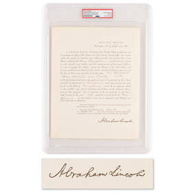
4 days LeftRR AuctionAbraham Lincoln Document Signed as President, Ordering Pennsylvania to Furnish Additional Troops for$1,000
Oct 06Schilb Antiquarian Rare Books1866 1ed Jefferson Davis Prison Life Civil War Slavery Confederate President CSA$140(4 bids)
Oct 27Schilb Antiquarian Rare Books1890 Civil War Secret Service 1st ed Wilkes Booth Lincoln Assassination Baker$27(3 bids)
Oct 12Fleischer's Auctions[CIVIL WAR] Spent during Gettysburg Campaign: Confederate $10 Richmond Note$100(1 bid)
Oct 27Schilb Antiquarian Rare Books1867 Illustrated CIVIL WAR Anecdotes Lincoln Assassination Gettysburg Union$24(2 bids)


![[CIVIL WAR, GETTYSBURG] Post-War Veteran Medals & Badges (1 of 2)](https://p1.liveauctioneers.com/7226/343781/186766932_1_x.jpg?height=282&quality=70&version=1726333566)
![[LINCOLN] General's Commission Signed by Lincoln (1 of 3)](https://p1.liveauctioneers.com/7226/343679/186654896_1_x.jpg?height=282&quality=70&version=1726945754)
![[CIVIL WAR] Captured Book Inscribed to Jeff. Davis (1 of 4)](https://p1.liveauctioneers.com/7226/343781/186766693_1_x.jpg?height=282&quality=70&version=1726333566)


![[CIVIL WAR] Letter re: Unwell Slave w/ CSA Stamps (1 of 2)](https://p1.liveauctioneers.com/7226/343679/186654962_1_x.jpg?height=282&quality=70&version=1726238840)


![[LINCOLN] Cleveland Ledger Assassination Issue (1 of 2)](https://p1.liveauctioneers.com/7226/343679/186654899_1_x.jpg?height=282&quality=70&version=1726238840)


![[CIVIL WAR] Spent during Gettysburg Campaign: Confederate $10 Richmond Note (1 of 2)](https://p1.liveauctioneers.com/7226/343781/186766894_1_x.jpg?height=282&quality=70&version=1726333566)
![[CIVIL WAR] Ulysses S. Grant Personal Memoirs 1st. Edition (1 of 4)](https://p1.liveauctioneers.com/7226/343679/186654914_1_x.jpg?height=282&quality=70&version=1726238840)
![[CIVIL WAR] 1864 Lincoln Illustrated Ticket (1 of 1)](https://p1.liveauctioneers.com/7226/343679/186654893_1_x.jpg?height=282&quality=70&version=1726238840)
![[CIVIL WAR] Alexandria Slave Pens, Brady CDV (1 of 2)](https://p1.liveauctioneers.com/7226/343679/186654939_1_x.jpg?height=282&quality=70&version=1726238840)
![[CIVIL WAR] Robert E. Lee Signed Portrait (1 of 1)](https://p1.liveauctioneers.com/7226/343781/186766781_1_x.jpg?height=282&quality=70&version=1726333566)


![[LINCOLN] Mourning Card (1 of 2)](https://p1.liveauctioneers.com/7226/343679/186654904_1_x.jpg?height=282&quality=70&version=1726238840)