Sold2020Large Framed Map of London, 1861Depicts London from the South Side of the Thames, this was a fold-out supplement to the illustrated London News, February 9, 1861, Rob Loudon Sr. Folds, creases, water stains in areas. Overall size: 2See Sold Price
Sold2022Large Framed Map of the City of Worcesterhas some creasing but presents nicely in the frame - Frame 71" x 61" Please see photos and come to the 2 day preview for condition.See Sold Price
Sold2023Bowen, Thomas 1789 Large Map. Europe"A New and Accurate Map of Europe" Copper Engraved Map Published 1789-91 by C. Cooke, London for "The New Royal Encyclopedia, Or, Complete Modern Universal Dictionary of Arts and Sciences..." by WilliSee Sold Price
Sold2023Gross, Alexander 1920 Lot of 26 Large Maps. EuropeIncl Germany, Austria, Russia, Netherlands, Belgium/Luxembourg, Norway/Sweden, Denmark/Iceland, Switzerland, Italy, France/Switzerland, Spain/Portugal, Europe Continent. Large Lithograph Maps PublisheSee Sold Price
Sold2020Bartholomew, John 1922 Lot of 4 Large Maps. EuropeIncl Europe Political, Orography/Vegetation/Races/Population, Western Europe Politcal, Eastern Political. Large Lithograph Maps Published 1922 by The Times, London for "The Times Survey Atlas of the WSee Sold Price
Sold2017Framed Needlework Sampler - "Rows of Birds"Description - A large framed needlework sampler "Rows of Birds". Dimensions - Frame - 27.5" x 47" x 36".See Sold Price
Sold2023ESTATE OF SEYMOUR STEIN: 3 LARGE FRAMED MAPS/PRINTS - NY, PEEKSILL, PHILADELPIA EXHIBITION, LARGESTESTATE OF SEYMOUR STEIN: 3 LARGE FRAMED MAPS/PRINTS - NY, PEEKSILL, PHILADELPIA EXHIBITION, LARGEST IS 40" X 41"See Sold Price
Sold2018Large Framed 1794 Map of America Laurie & Whittle1794, London New Map of America & The West India Islands. With detailed side maps of California, and Baffin & Hudson Bay. Published by Laurie and Whittle. Map measures approximately 43.5" L x 49.5" H,See Sold Price
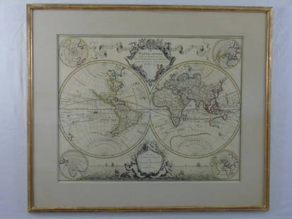
Sold2016Large Framed World Map w/ Latin InscriptionsLarge Framed World Map w/ Latin Inscriptions. Hand colored. Professionally framed and matted. Titled Mappe Monde. Measures 28 by 33 inches.See Sold Price
Sold2023Large Oriental Framed Needlework on SilkLarge Oriental Framed Needlework on Silk . 76 1/4" x 32 3/4" "ALL DESCRIPTIONS AND ANY CONDITION STATEMENT GIVEN BY LANGSTON AUCTION GALLERY ARE STRICTLY OPINIONS AND LANGSTON'S SHALL HAVE NO RESPONSISee Sold Price
Sold2021Antique Framed Map of Europe, Europa Guilielmo BlaeuwAntique Color Map of Europe, Dutch Cartography. "Europa Recens Descripta" by Guilielmo Blaeuw, a cartographer for the Dutch East India Company. Lots of colorful detail of different nationalitiSee Sold Price
Sold2018LARGE FRAMED INDIAN NEEDLEWORK TAPESTRYDimensions: (Frame) H 47" x W 83" Condition: Few stains including large stain to center. Couple small holes. Some fraying. Frame loose. M277See Sold Price
Sold2022Large Framed 1846 Map of FloridaLarge Framed 1846 Map of Florida; a reprint of the original, matted, glazed, and mounted in a wood frame. This map shows the state when central Florida was one large county aptly named Mosquito. All aSee Sold Price
Sold2023LARGE VICTORIAN FRAMED NEEDLE WORKSTEERS DRINKING FROM CREEK. MINOR DAMAGE TO FRAME. 21 1/2" x 33 1/2" IN FRAME.See Sold Price
Sold2024Two (2) Antique 18th C. Copper Engraved Framed Maps - America & EuropeTwo (2) antique 18th C. copper engraved framed maps. One of Amerique and other titled Carte d'Europe. Both framed under glass. Frame Size: 13.5H x 14.5W (each)See Sold Price
Sold2024Blackie (Pub) 1882 Lot of 6 Large Maps of Europe7 Maps on 6 Sheets. Incl Europe Continent, Belgium/Netherlands, Denmark, British Isles, Ireland, France, and Sweden/Norway. Lithograph Maps Published 1882 by Blackie & Son, London for "The ComprehensiSee Sold Price
Sold2019Bartholomew, John 1922 Lot of 4 Large Maps of EuropeLarge Lithograph Maps Published 1922 by The Times, London for "The Times Survey Atlas of the World" Maps by John George Bartholomew of the Edinburgh Geographical Institute. Centre fold as issued. PapeSee Sold Price
Sold2019Bartholomew, John 1922 Lot of 8 Large Maps of EuropeIncl Belgium/Holland, Spain/Portugal - East & West, Northern Italy/Austria, Southern Italy, Central European States, Germany - South & West. Large Lithograph Maps Published 1922 by The Times, London fSee Sold Price
Sold2022Universal Atlas 1893 Lot of 9 Large Maps of EuropeIncl Austrian Alps, Switzerland, Spain/Portugal, Austria/Hungary, Germany, France, England/Wales Lithograph Maps Published 1893 by Cassell & Co., London for "The Universal Atlas" Centre fold as issuedSee Sold Price
Sold2023Delaware and Hudson RR Framed Bridge Line Route Map 1823-1973This large framed poster/map is from the Delaware and Hudson Railroad and shows their routes for both canal and railroad from 1823 to 1973, between New England and Canada. An excellent, full color pieSee Sold Price
Sold20191872 Asher and Adams Map of Europe -- Asher & Adams'Title: 1872 Asher and Adams Map of Europe -- Asher & Adams' Europe Date: 1872 New York Cartographer: Asher & Adams Size: 15.8 x 22.8 in. Additional Information: A very nice, large map of Europe. The mSee Sold Price
Sold2022Three Framed Maps from the 19th-20th centuriesThree framed maps of Europe and Asia minor from the 19th-20 centuriesSee Sold Price
Sold2021Large map of Eastern Europe (60.5in x 35.5in)Large map of Eastern Europe The frame:(60.5in x 35.5in), the map:32.5" x 57.5".See Sold Price
Sold2021Large Matted and Framed Map of Norfolk Virginia:Large Matted and Framed Map of Norfolk Virginia: Stylized Blazon Coat of Arms of Howard Duke of Norfolk (Premier Duke of England) Motto is "Virtuecont Alone is Invincible". Labeled JH DINGEE, Banker,See Sold Price
2 days LeftMynt AuctionsIan McDiarmid Signed Star Wars 16x20 Darth Sidious vs Yoda Photo- JSA W *Si$10
4 days LeftMynt AuctionsMagic Johnson 1978 Sports Illustrated 11/27 1st SI Cover Michigan State 84356$10
4 days LeftMynt AuctionsMagic Johnson LA Lakers Signed/Autographed 16x20 SI Photo Framed Beckett 149212$10
5 days LeftMynt AuctionsIan McDiarmid Signed Star Wars 16x20 Darth Sidious vs Yoda Photo- JSA W *Si$10
3 days LeftMynt Auctions6 x 9 GREEN Multi Color Original 19th Century Savonnerie Hooked Rug EUROPEAN$10
2 days LeftTrillium Antique Prints & Rare BooksPtolemy & Magini, pub. 1620 - Map of the Ancient World with Africa, Europe, Asia$50
Featured16 hrs LeftOAB AuctionsAlexandra Nechita Summer In Europe Large Serigraph On Canvas Signed Cubism Art$750