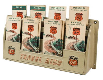
Sold2023Vintage Phillips 66 Road Map Embossed Display RackVintage Phillips 66 embossed plastic road map display rack full with original 1930s Phillips 66 maps. Rack has discoloration, some expected chips/ cracks, and wear from use and age. Displays well withSee Sold Price
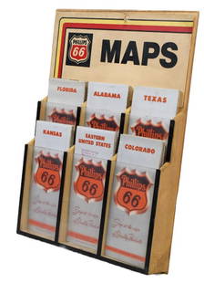
Sold2023Vintage Phillips 66 Road Map Display RackVintage Phillips 66 plastic road map display rack full with original 1950s Phillips 66 maps. Rack has discoloration, some expected minor cracks, and wear from use and age. Displays well with maps. OveSee Sold Price
Sold20201950’s era Mobil dealer map display rack, 24 x 15.1950’s era Mobil dealer map display rack, wall hanging, with period maps, 24 x 15.5See Sold Price
Sold2022TEXACO TRAVEL SERVICE SERVICE STATION MAP DISPLAY RACK.SST. CA. 1950's Service Station Map Rack for "Texaco Touring Service" showing Single Sided Tin Attachment Sign. CONDITION: Rack overall outstanding throughout showing excellent teal color with minimalSee Sold Price
Sold2019Lot of 3: Mobilgas Tin Map Display Rack & Two RadiatorLot Consists Of: First is a Mobilgas Tin Road Map Display, grade 7.75. Second is a National Radiator Cap Cardboard Display, missing two caps, grade 7.5. Third is an Atlas Radiator Cap Cardboard DisplaSee Sold Price
Sold2022Gulf Tourgide Service Metal Map Rack DisplayRated 8, 8"x9"x5", has good color and shine has light wear comes with several maps.See Sold Price
Sold2023Sinclair Map Rack Reminder Box & 50 Year BookNice lot of Sinclair items. The Map rack displays well and includes multiple maps. Reminder box from Truesdell Oil Co is clean with light wear. The book ?A great Name in Oil Sinclair through Fifty YeaSee Sold Price
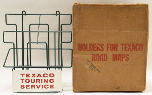
Sold2021Vintage NOS Texaco Road Map Metal Display RackVintage new old stock Texaco road map metal display rack in original box. Nice condition with light wear from age and storage. Display rack measures approximately 10-1/2" tall by 9" across.See Sold Price
Sold2022SHELL GASOLINE TIN SERVICE STATION MAP DISPLAY W/ VARIOUS SHELL MAPS.SST. A nice example of this scarce Shell Service Station Map Rack complete with various Shell Maps. Display is in fair condition showing good color and gloss with areas of fading in the red as well asSee Sold Price
Sold20191909 McNally State & Seneca Co. Ohio Survey/AtlasClean, solid atlas containing full-color maps of each state and maps of the world. Large 19 x 26 Railroad Map of Ohio detached but separate (very good cond.) Separate foldout map of the world is detacSee Sold Price
Sold2023Early Civil War Map of North AmericaEntitled Supplement to the Illustrated London News, July 1, 1861, Stephenson colortoned to show the Union states and Seceded or Rebel states. Full title being: Map of the United States of America, UppSee Sold Price
Sold2023Authorized Free Maps & Information Wood Map Rack w/Maps (TAC)rated 9, 21.5"x20"x3", the wood map display has good color, light wear, has a place for payment of one dime on the honor system, comes with a few road maps. TAC #018878See Sold Price
Sold2016VINTAGE RAND McNALLY MAP DISPLAY w/ MAPSVery early Rand McNally display Comes full of vintage maps. 19"x7" Very GoodSee Sold Price
Sold2024Crams Railroad Map of New York-1881This is a Crams Railroad Map of New York dated 1881, Has a great fold-out full color map of the state of New York showing all railroad lines. Has almost no tears or frays. Booklet has 36 pages of counSee Sold Price
Sold2018First Edition Mitchell's Traveller's GuideYoung, J. H. (1792-c. 1864). Mitchell's Traveller's Guide Through the United States, a Map of the Roads, Distances, Steam Boat and Canal Routes & C. by J.H. Young. Engraved map with full color. S. AugSee Sold Price
Sold2017Colton MAP OF THE STATE OF MISSISSIPPI 1867 EngravedDetails: COLTON, George W. (1827-1901) & Charles B. (1832-1916). Colton's Map of the State of Mississippi. New York: G.W. & C.B. Colton & Co., 1867. Engraved folding pocket map, full contemporary hanSee Sold Price
Sold2024A Sunkist Disneyland Souvenir Map Offer Display.(Sunkist, 1964) An original store display featuring a promotion for full-color Disneyland Park Maps, offered by Sunkist Navel Oranges. This store display is accompanied by its original pad of approximSee Sold Price
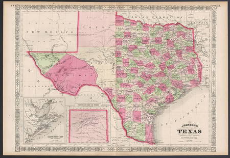
Sold2023Excellent example of Johnson’s Texas, 1866Authentic and impressive vintage map of Texas. One of the more collectible maps to be produced in the mid-19th century. A highly desirable map that details the state in full. Shows the elevated TableSee Sold Price
Sold2023Lovely vintage pre-Civil War RR map of MichiganFascinating, highly detailed map of Michigan with original full hand-coloring. Cowperthwait produced some of the most attractive state maps of the period and this one is particularly nice. PositionedSee Sold Price
Sold2022Exceptional map of Johnson's Texas, 1866Authentic and impressive vintage map of Texas. A highly desirable map that details the state in full. Shows the elevated Table Lands, the U. S. Mail Route, the Staked Plain (El Llando Estadado), numerSee Sold Price
Sold2022Excellent map of the U. S. from Gray’s National AtlasFirst time offered. Large, impressive and highly detailed map of the United States with full, original hand-coloring done at the time of publishing. This double-age map includes two inset maps of AlasSee Sold Price
Sold2023Vintage Signed Portrait of WWII Airforce Brigadier GeneralLarge portrait of Brigadier General standing in front of a map of central United States in full uniform and cap. Silver gelatin print. Legible handwritten text reads, To Sgt. Walter Gray... Brig. Gen.See Sold Price
Sold2022Motor Oil Display Rack, Texaco w/8 sample cans (empty w/out tops) & 5 full qts of Sinclair, Kendall,Motor Oil Display Rack, Texaco w/8 sample cans (empty w/out tops) & 5 full qts of Sinclair, Kendall, Quaker State & Royal Triton Motor Oil, most in VG cond, display 12.5"H x 10"W.See Sold Price
Sold20201861 Civil War military map in full hand-colorLarge format, double-page “Johnson’s New Military Map of the United States showing the Forts, Military Posts &c. with Enlarged Plans of Southern Harbors” by Johnson and Ward. Original and vividSee Sold Price
2024Jasper521578 BIBLE ILLUSTRATED by T. STIMMER BIBLIA SACRA antique 16th CENTURY PIGSKINSee Sold Price
23 hrs LeftJasper52Carte de la Scandinavie… Scandinavia Sweden Norway Denmark. LAPIE 1830 old map$45
7 days LeftJasper52Johnson's New Military Map of the United States Showing the Forts, Military Posts &C. With Enlarged$65
Featured2024Jasper521810 c. Didot Map of Central-Eastern Mediterranean Sea Region -- Carte des Etats de la repiblique deSee Sold Price
Featured23 hrs LeftJasper52Europe after the Congress of Vienna. 4 sheets. 128x106cm. THOMSON 1817 old map$550
2024Jasper521898 Rand McNally Map of Texas [verso] Indian Territory and Oklahoma -- Texas [verso] Oklahoma andSee Sold Price
98 Lots AwayJasper521598 Munster Map of Frankfurt an der Oder -- Franckfurt an der Oder Anno Dni 1548$80
23 hrs LeftJasper52South-west & Central Europe. Switzerland includes Haute-Savoie. THOMSON 1817 map$100
23 hrs LeftJasper52South-west & Central Europe. Switzerland includes Haute-Savoie. THOMSON 1830 map$100


![Untitled. Midwest. [Map Issued With the Official Inter-State Railway Guide] (1 of 1)](https://p1.liveauctioneers.com/5584/329422/177662238_1_x.jpg?height=282&quality=70&version=1715717898)


![1898 Rand McNally Map of Texas [verso] Indian Territory and Oklahoma -- Texas [verso] Oklahoma and (1 of 2)](https://p1.liveauctioneers.com/5584/328338/176911581_1_x.jpg?height=282&quality=70&version=1715113718)


