Sold2019Nicolas De Fer (1646-1720), "Cette Carte de CalifornieNicolas De Fer (1646-1720), "Cette Carte de Californie et du Nouveau Mexique," 1700, hand colored, H.- 11 1/2 in., W.- 15 1/4 in.See Sold Price
Sold2024Nicholas de Fer, Map of California of 1705Nicholas de Fer (1646-1720) Map of California of 1705 (Cette carte de Californie et du Nouveau Mexique, 1705); together with two other California related framed ephemera.Assumed second state (1705) ofSee Sold Price
Sold2019Mallet map of island of California 1683Heading: Author: Mallet, Alain Manesson Title: Nouveau Mexique et Californie Place Published: Paris Publisher: Date Published: 1683 Description: Copper-engraved map. 14.5x1See Sold Price
Sold20191749 Robert de Vaugondy Map of Texas and NorthernTitle: 1749 Robert de Vaugondy Map of Texas and Northern Mexico -- Partie Du Mexique ou De La Nouvle. Espagne ou se trouve L'Audce De Guadalajara, Nouveau Mexique, Nouvelle Navarre, Californie &c. DatSee Sold Price
Sold20211771 Bonne Map of US South, Mexico and Central AmericaTitle: 1771 Bonne Map of US South, Mexico and Central America -- Carte du Mexique ou de la Nlle. Espagne Contenant Aussi le Nouveau Mexique, la Californie, avec une Partie des Pays Adjacents… CartogSee Sold Price
Sold2019Mexique, avec la Floride et la Basse Louisiane, partieTITLE/CONTENT OF MAP: 'L'ancien et le nouveau Mexique, avec la Floride et la Basse Louisiane, partie Orientale [Mexico and New Mexico, with Florida and Lower Louisiana, western part]' The top image onSee Sold Price
Sold2019Mexique'. Mexico inc Texas, California & western UnitedTITLE/CONTENT OF MAP: 'Carte géographique, statistique et historique du Mexique' The top image on the right hand side shows the entire map. To view a close up of the map showing the level of printedSee Sold Price
Sold2017Bonne: Les Isles Antilles et le Golfe du Méxique, 1780Title/Content of Map: 'Les Isles Antilles et le Golfe du Méxique' A map of the Caribbean, The Gulf of Mexico, Florida & Central America This map is folding hence the centrefold line may show on the iSee Sold Price
Sold2016Carte Genrale Des Etats-Unis Et Du Mexique 1862Map Title: Carte Genrale Des Etats-Unis Et Du Mexique Date: 1862 Publisher: Andriveau-Goujon: Paris Size: 24.3 x 18.25 inches Eastern sheet only. Only east of the Mississippi shown, only Yucatan shownSee Sold Price
Sold2019Carte du Golfe du Mexique et des Isles de l'Amerique'TITLE/CONTENT OF MAP: 'Carte du Golfe du Mexique et des Isles de l'Amerique [Map of the Gulf of Mexico and the Caribbean islands]' DATE PRINTED: 1754 IMAGE SIZE: Approx 28.5 x 39.0cm, 11.25 x 15.5 incSee Sold Price
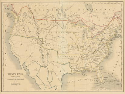
Sold2023EUSTACHE-HYACINTHE LANGLOIS (1777-1837) A MEXICAN TEXAS MAP, "Etats Unis et Partie de L'AméEUSTACHE-HYACINTHE LANGLOIS (1777-1837) A MEXICAN TEXAS MAP, "Etats Unis et Partie de L'Amérique Anglaise et du Mexique," PARIS, CIRCA 1830, lithograph on cream wove paper with hand color, probabSee Sold Price
Sold2018Brué: Mexico/Southwest US/Central America InsetMap Title: Carte Generale du Mexique et de la Partie Sud-Ouest des Etats Unis Cartographer: Brue/Levasseur Place & Date: Paris / 1876 Size: 14 1/4" x 20" Condition: wash color; light overall age toninSee Sold Price
Sold2018Two framed maps including Carte Du Golfe Du Mexique etTwo framed maps including Carte Du Golfe Du Mexique et Des Isles Antilles (sight size: 13" x 17") and Orbis Universal map of the world with plaque: David Rockefeller In appreciation for your tirelessSee Sold Price
Sold2016Carte Contenant le Royaume du Mexique la Floridie, 1719Map: Carte Contenant le Royaume du Mexique et la Floridie Cartographer: H. Chatelain Publishing: 1719 Size: 20.6 x 15.9 inches This map is a derivative of Delisle's landmark map of the southern part oSee Sold Price
Sold2022Scarce 1705 map of North America by Nicolas de Fer (Calif. as island)Nice example of de Fer's scarce map of North America, first published in Paris in 1693. This specimen with a 1705 date is from the 1723 edition of de Fer’s Petit et Nouveau Atlas and features laterSee Sold Price
Sold2022(CALIFORNIA AS AN ISLAND.) Joannes Ribbius; and Nicolas Sanson. Audience de Guadalajara, Nouveau(CALIFORNIA AS AN ISLAND.) Joannes Ribbius; and Nicolas Sanson. Audience de Guadalajara, Nouveau Mexique, Californie, &c. Small double-page engraved map of the North American southwest showing CaliforSee Sold Price
Sold2017Bellin: Antique Map of Gulf of Mexico & Caribbean, 1749Map: Carte Reduite du Golphe du Mexique et des Isles de l'Amerique Cartographer: Bellin Place & Date: Paris / 1749 Size: 32 1/4" x 21 1/8" Condition: outline color (cartouche uncolored); water stainsSee Sold Price
Sold2019Bellin Map of the CarribeanBELLIN, Jacques Nicolas (1703-1772). Carte du Golphe du Mexique et des Isles de l'Amerique... Engraved map with hand color in full. Paris, 1754. 11 3/8” x 15 1/4” visible, 16 1/2” x 20” framedSee Sold Price
Sold2023Carte du Golfe du Mexique et des Isles de l'Amerique' Caribbean BELLIN 1754 mapTitle: Carte du Golfe du Mexique et des Isles de l'Amerique' Caribbean BELLIN 1754 map Description: Carte du Golfe du Mexique et des Isles de l'Amerique [Map of the Gulf of Mexico and the Caribbean isSee Sold Price
Sold2017Chatelain: Antique Map of Mexico & Florida, 1719Map: Carte contenant le Royaume du Mexique et la Floride Cartographer: Chatelain Place & Date: Amsterdam / 1719 Size: 20 1/2" x 16" Condition: b&w; margins frayed; overall age toning; stain on upper pSee Sold Price
Sold2019Nouveau Mexique, Louisiane, Canada. North America.TITLE/CONTENT OF MAP: 'Nouveau Mexique, Louisiane, Canada, et Nlle Angleterre. Par M. Brion. Ã Paris chez Desnos rue St. Jacques au Globe. 1766' North America comprising New Mexico, Louisiana, CanaSee Sold Price
Sold2017Brion de la Tour: Antique Map of North America, 1766Map: Nouveau Mexique, Louisiane, Canada, et Nlle. Angleterre Cartographer: Brion de la Tour Place & Date: Paris / 1766 Size: 19" x 11" Condition: outline color; light overall age toning The highly detSee Sold Price
Sold20231754 Carte Du Golphe Du Mexique, Bellin1754 Map Titled "CARTE DU GOLPHE DU MEXIQUE ET DES ISLES DE L'AMERIQUE Pour servir a l'Histoire Generale des Voyages." and "Par M. Bellin Ingr. de la Marine 1754". Copper plate engraving with hand colSee Sold Price
Sold2019Tabula Geographica Mexicae et Floridae, map of MexicoTabula Geographica Mexicae et Floridae, map of Mexico and Florida, hand colored copper engraving, "Carte du Mexique et de la Floride des Terres Angloises et des Isles Antilles", 1722 Jean Covens &See Sold Price
Featured4 days LeftJasper52Carte du Golfe du Mexique et des Isles de l'Amerique' Caribbean BELLIN 1754 map$200
4 days LeftJasper52Antilles, Golfe du Mexique & Amérique Centrale. Caribbean. MALTE-BRUN c1871 map$35
6 days LeftArt Legacy AuctionsLithograph from 1931 Chemin de Fer de Paris a Orleans et du midi salies de Bearn vintage travel$550
3 days LeftJasper521753 Robert de Vaugondy Map of Central France -- Gouvernemens Generaux De La Marche, Du Limosin Et$45
6 days LeftTrillium Antique Prints & Rare BooksBonne - Pair of Maps (Eastern & Northern Hemisphere)$75
May 22PiasaEkoi mask, Nigeria / Cameroon Wood, leather and hair Published in the catalogue of the exhibition€2,400
May 15University ArchivesRare 18th C. French Engraving Showing Chilean Hockey Player & Other Exotic Customs$140


![[MAP]. FER. Californie et du Nouveau Mexique. 1700. First Image](https://p1.liveauctioneers.com/514/38480/16487188_1_x.jpg?height=300&quality=1&version=1363614971&width=300)
![[MAP]. FER. Californie et du Nouveau Mexique. 1700. First Image](https://p1.liveauctioneers.com/514/38480/16487188_1_x.jpg?height=300&quality=95&version=1363614971&width=300)


![Mexique, avec la Floride et la Basse Louisiane, partie: TITLE/CONTENT OF MAP: 'L'ancien et le nouveau Mexique, avec la Floride et la Basse Louisiane, partie Orientale [Mexico and New Mexico, with Florida and Lower Louisiana, western part]' The top image on](https://p1.liveauctioneers.com/5584/147595/74587322_1_x.jpg?height=310&quality=70&version=1565730371)


![Carte du Golfe du Mexique et des Isles de l'Amerique': TITLE/CONTENT OF MAP: 'Carte du Golfe du Mexique et des Isles de l'Amerique [Map of the Gulf of Mexico and the Caribbean islands]' DATE PRINTED: 1754 IMAGE SIZE: Approx 28.5 x 39.0cm, 11.25 x 15.5 inc](https://p1.liveauctioneers.com/5584/144578/73088245_1_x.jpg?height=310&quality=70&version=1561513819)


![[EPHEMERA]. Group of Booklets, Magazines, Postcards, Brochu... (1 of 1)](https://p1.liveauctioneers.com/928/328184/176813372_1_x.jpg?height=282&quality=70&version=1714496988)


