Sold2022Encyclo. Britannica 1890's Pair of Maps. Sumatra MalayaLithograph Map Published 1875-98, Edinburgh & London for "Encyclopaedia Britannica" Ninth Edition. Paper Size: 10.5 x 8 inch (27 x 21cm) Good ConditionSee Sold Price
Sold2022Encyclo. Britannica C1880 Map. Sumatra, IndonesiaLithograph Maps Published 1875-98, Edinburgh & London for "Encyclopaedia Britannica" Ninth Edition. Paper Size: 10.5 x 8 inch (27 x 21cm) Good ConditionSee Sold Price
Sold2018SUMATRA & JAVA. Dutch East Indies. Singapore.TITLE/CONTENT OF MAP: 'Sumatra; Java' DATE PRINTED: 1863 IMAGE SIZE: Approx 32.0 x 45.5cm, 12.75 x 18 inches (Large) TYPE: Antique map with original outline colour CONDITION: Good; suitable for framinSee Sold Price
Sold2021Sumatra 1897Title/Content of Map: Sumatra 1897 Date Printed: 1897Material/Medium: paper Size: 12x 14.5 inches Cram's Universal Atlas Geographical, Astronomical and Historical Atlas Reserve: $30.00 Shipping: DomSee Sold Price
Sold20211750 Bellin Engraved Map of SumatraA folding map of the island of Sumatra , "Carte de L'Isle De Sumatra…", by Jacque Bellin circa 1750, Paris. Close trimmed at top margin. Fine, measures 15.5 x 10". Reserve: $80.00 Shipping: DomesticSee Sold Price
Sold2017Jansson: Map of Malacca, Sumatra, 1652Map: Sumatrae et Insularum Locorumque . . . Tabula Nova Cartographer: Jan Jansson Place & Date: Amsterdam / 1652 Size: 20 1/2" x 16 3/4" Condition: Minor age browning, especially at fold, as is commonSee Sold Price
Sold20211757 Map of Java Sumatra BorneoCarte Des Isles de Java, Sumatra, Borneo & Les Detroits de la Sonde Malaca et Banca Golphe de Siam, by Jacques Bellin, printed at Paris circa 1757. Measures 14 x 10". Fine. Reserve: $60.00 Shipping:See Sold Price
Sold2021(INDONESIA.) Dutch East Indies Topographic Department.(INDONESIA.) Dutch East Indies Topographic Department. Schetskaart van de Residentie Palembang. Massive color-lithographed topographical case map of southern Sumatra. 4 large panels, each 29x35 inchesSee Sold Price
Sold20191945 US Army Escape Silk Map of Northern Sumatra/MalayTitle/Content of Map: 1945 US Army Escape Silk Map of Northern Sumatra/Malay Peninsula [verso] Central Sumatra -- [Escape Silk Map] C800 [verso] C920 Cloth Chart Date: 1945, Washington DC CartographerSee Sold Price
Sold2022US DEPARTMENT OF DEFENSE. WORLD WAR 2, SUMATRA, INDONESIA AND DUTCH EAST INDIES MAPS (1944-1946)US DEPARTMENT OF DEFENSE. WORLD WAR 2, SUMATRA, INDONESIA AND DUTCH EAST INDIES MAPS (1944-1946). US Army Map Service. Eight maps from Dutch Sumatra and Timor: Gle Jeueng (paper) and Lho'Nga (paper) eSee Sold Price
Sold2022Océanique. Partie de l'ile de Sumatra #18. West Sumatra. VANDERMAELEN 1827 mapTITLE/CONTENT OF MAP: Océanique - Partie de l'ile de Sumatra [Note sur l'île de Sumatra] - No. 18 Western Sumatra, Siberut and the Mentawai Islands, Indonesia DATE PRINTED: 1827 IMAGE SIZE:See Sold Price
Sold20191794 Sea Chart of South Part Sumatra 18th Century Mapa very rare 18th century antique sea chart. This is an uncolored copper plate engraving. Image measures 24\" x 32.5\". This map has been matted and is ready for framing. A stunning chart of the southeSee Sold Price
Sold2024MAP, Balkans, MunsterIstria Peninsula, Croatia. Sebastian Munster, [Title on Verso] Hysterreich, from Cosmographei oder Beschreibung aller Länder, 1556 (published). Hand Color. Woodblock map of Istria, in present-day CroSee Sold Price
Sold2022US DEPARTMENT OF DEFENSE. WORLD WAR 2, SUMATRA, INDONESIA AND DUTCH EAST INDIES MAPS (1943-1946)US DEPARTMENT OF DEFENSE. WORLD WAR 2, SUMATRA, INDONESIA AND DUTCH EAST INDIES MAPS (1943-1946). US Army Map Service. Eight maps, from Dutch East Indies: Dutch Timor, Isle of Roti; Portuguese Timor;See Sold Price
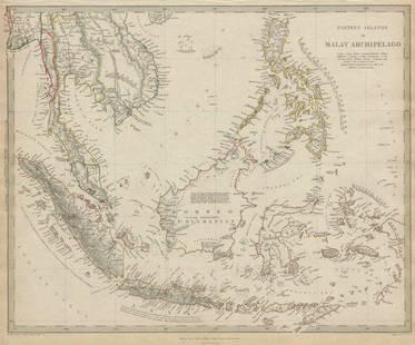
Sold2020MALAY ARCHIPELAGO Indonesia Malaysia PhilippinesTITLE/CONTENT OF MAP: 'EASTERN ISLANDS OR THE MALAY ARCHIPELAGO. Sumatra, Java, Borneo, etc' The top image on the right hand side shows the entire map. To view a close up of the map showing the levelSee Sold Price
Sold2022Jacques-Nicolas Bellin (1703-1772), After - Antique Map of Malaysia, Indonesia"Carte des Isles de Java, Sumatra, Borneo &c."(Malaysia, Indonesia). Engraved map from the Dutch edition of Bellin's Histoire General des Voyages. Original hand-coloring; fairly foxed, most with an eaSee Sold Price
Sold2020MALAY ARCHIPELAGO Indonesia Malaysia PhilippinesTITLE/CONTENT OF MAP: 'EASTERN ISLANDS OR THE MALAY ARCHIPELAGO. Sumatra, Java, Borneo, etc' The top image on the right hand side shows the entire map. To view a close up of the map showing the levelSee Sold Price
Sold2021Stanford (Pub) 1894 Lot of 4 Maps of IndonesiaIncl Sumatra, Java, Celebes and Sunda. Lithograph Maps Published 1894 by Edward Stanford, London for "Stanford's Compendium of Geography and Travel. Australasia. Malaysia and the Pacific ArchipelagoesSee Sold Price
Sold20191792 Elwe Map of Indian Ocean Islands -- Parte de laTitle: 1792 Elwe Map of Indian Ocean Islands -- Parte de la Nouvelle Grande Carte des Indes Orientales, Contenant les Isles Maldives, Ceylan, Malacca, Sumatra &c. Avec Les Terres Adjacentes De CouchinSee Sold Price
Sold2021Head Hunters of Borneo, with Travel MapHeading: (Borneo) Author: Bock, Carl Title: The Head-Hunters of Borneo: A Narrative of Travel Up the Mahakkam and Down the Barito; Also, Journeyings in Sumatra Place Published: London Publisher:SampsoSee Sold Price
Sold2020Henri Abraham Chatelain Map of Asia ca. 1700Henri Abraham Chatelain (1684-1743), "Carte des Indes, de la Chine & des Iles de Sumatra, Java &c, Dresee sur la Memoires les plus nouveaux & sur les meillures observations, tirees des RelatiSee Sold Price
Sold2018Mallet: Antique Map Spanish/Catholic Netherlands, 1683Title/Content of Map: 'Pays Bas Catholiques' The Spanish Netherlands (Dutch: Spaanse Nederlanden, Spanish: Países Bajos españoles) was a portion of the Low Countries controlled by Spain from 1556 toSee Sold Price
Sold2022TWO HAND-COLORED MAPS OF THE EAST INDIESTWO HAND-COLORED MAPS OF THE EAST INDIES1) “Carte des Isles de Java, Sumatra, Borneo & Les Detroits de la Sonde Malaca et Banca Golphe de Siam …”, Jacques Bellin, Paris, circa 1762.See Sold Price
4 days LeftTrillium Antique Prints & Rare BooksSanson - Map of the Sunda Islands, Sumatra, Java, & Borneo$75
May 29Cedarburg Auction & Appraisals LLCSet of Four Maps Showing All of Spain and Portugal$375(2 bids)
Jun 07Freeman's | Hindman[MAP]. TODESCHI, Pietro. [Nova et Acurata Totius Americae Tabula auct. G.I. Blaeu] America quarta$5,000
May 29Cedarburg Auction & Appraisals LLCRare 1877 Double sided map of Milwaukee and Wisconsin$40(4 bids)
Jun 07Freeman's | Hindman[MAP]. ORTELIUS, Abraham. Americae Sive Novi Orbis, Nova Descriptio. 1573.$1,000(1 bid)
May 30Antiques Online AuctionsVintage Texas 1845 Map Printed in 1986, Compiled by John Davis$11(4 bids)
5 days LeftArarity AuctionsThomson's 1817 Hand Colored Map Comparative Heights of the World's Great Mountains$50
Featured6 hrs LeftJasper52Johnson's New Military Map of the United States Showing the Forts, Military Posts &C. With Enlarged$65


![1945 US Army Escape Silk Map of Northern Sumatra/Malay: Title/Content of Map: 1945 US Army Escape Silk Map of Northern Sumatra/Malay Peninsula [verso] Central Sumatra -- [Escape Silk Map] C800 [verso] C920 Cloth Chart Date: 1945, Washington DC Cartographer](https://p1.liveauctioneers.com/5584/134050/68048822_1_x.jpg?height=310&quality=70&version=1546996032)

![Océanique. Partie de l'ile de Sumatra #18. West Sumatra. VANDERMAELEN 1827 map: TITLE/CONTENT OF MAP: Océanique - Partie de l'ile de Sumatra [Note sur l'île de Sumatra] - No. 18 Western Sumatra, Siberut and the Mentawai Islands, Indonesia DATE PRINTED: 1827 IMAGE SIZE:](https://p1.liveauctioneers.com/5584/264830/138097484_1_x.jpg?height=310&quality=70&version=1666125289)

![MAP, Balkans, Munster: Istria Peninsula, Croatia. Sebastian Munster, [Title on Verso] Hysterreich, from Cosmographei oder Beschreibung aller Länder, 1556 (published). Hand Color. Woodblock map of Istria, in present-day Cro](https://p1.liveauctioneers.com/6576/320593/172252548_1_x.jpg?height=310&quality=70&version=1708729193)


![[MAP]. TODESCHI, Pietro. [Nova et Acurata Totius Americae Tabula auct. G.I. Blaeu] America quarta (1 of 1)](https://p1.liveauctioneers.com/197/329395/177650542_1_x.jpg?height=282&quality=70&version=1715364962)


![[MAP]. ORTELIUS, Abraham. Americae Sive Novi Orbis, Nova Descriptio. 1573. (1 of 2)](https://p1.liveauctioneers.com/197/329395/177650534_1_x.jpg?height=282&quality=70&version=1715364962)
![[MAPS]. A group of 3 engraved maps, most with hand-coloring. (1 of 4)](https://p1.liveauctioneers.com/197/328642/177014805_1_x.jpg?height=282&quality=70&version=1714760103)


