Sold2020New Tracks In North America 1stNew Tracks In North America A Journal of Travel and Adventure Engraved in the Survey for a Southern Railroad to the Pacific Ocean During 1867 - 1868. Two volume set. NumerSee Sold Price
Sold2022Real estate map for south part of San Francisco 1868Heading: -1868 Author: Kower, Emile Title: Map of the Golden Gate Homestead Association Place Published: San Francisco Publisher:Britton & Rey's Lithographic Steam Press Date Published: 1868<See Sold Price
Sold2021Kent Estate Map, Chevening.- Barham (surveyor) The HomeKent Estate Map, Chevening.- Barham (surveyor) The Home Farm In Chevening Kent Belonging to The Ri.t Hon.ble Lord Amherst, manuscript watercolour estate map on vellum, fold, 475 x 500mm., 1797; and anSee Sold Price
Sold2022KENT – LYDD – MANUSCRIPT ESTATE MAP 'A Map of a Farm lying in the Parish of Lydd in ...KENT – MANUSCRIPT ESTATE PLAN 'A Map of a Farm lying in the Parish of Lydd in the County of Kent Belonging to the Reverd. Mr Richard Monins 1774.', manuscript map by Henry Maxted & Isaac Terry,See Sold Price
Sold2020Real estate map of Berkeley Woods with ms. noted, 1917Heading: (California - Contra Costa County) Author: Title: Map of Berkeley Woods Contra Costa County, Cal. Scale 1 in. = 100 feet Place Published: [Berkeley, CA] Publisher: Date Published:See Sold Price
Sold2020Pocket real estate map of Bellingham WA 1910Heading: (Washington - Bellingham) Author: Title: Map of Bellingham north, Washington Place Published: Bellingham, Wash. Publisher:Bellingham Bay Improvement Co Date Published: 1910 DeSee Sold Price
Sold2022Sutro Heights real estate map c.1895Heading: -1895 Author: Title: Map of Sutro Heights. Lots for Sale by Will E. Fisher & Co., Agents Place Published: San Francisco Publisher: Date Published: c.1895 Description: LSee Sold Price
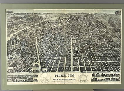
Sold2019Rockland county, NY Ariel maps Real Estate map rareRockland county, NY Ariel maps Real Estate map rareSee Sold Price
Sold20161868 MAP OF NEW JERSEY19th century map of New Jersey. Framed measures 15.5" x 11". Label on verso Argosy 116 E. 59th Street, NYC.See Sold Price
Sold2022MEDITERRANEAN SEA. Submarine telegraph cables. steamship routes. LOWRY 1868 mapTITLE/CONTENT OF MAP: 'Map of the Mediterranean and Adjacent Countries (on Mercator's Projection) Shewing the Submarine Telegraph Cables, and Lengths of the principal Steam Routes' DATE PRINTED: 1868See Sold Price
Sold2024Gano Estate Map, Spring Grove, Avondale & Cincinnati RailwayAmerica, 19th century. A map and letter dating to 1881 on the topic of the Gano Estate pertaining to the Spring Grove, Avondale & Cincinnati Railway. 428See Sold Price
Sold20231868 Map of Brandywine New Castle DelawareMap of Brandywine New Castle Delaware 1868 15x15 inchesSee Sold Price
Sold2022France.- Manuscript estate maps.- Marche (Lecoy de la) [Survey of the estates of Château-France.- Manuscript estate maps.- Marche (Lecoy de la) [Survey of the estates of Château-Renault], manuscript, double-page preface and 2 tables, 9 double-page hand-coloured maps (numbered 2-10, aSee Sold Price
Sold20212 Early Estate Maps2 early estate maps. Hand colored all over with frame. 17" wide, 23" tall.See Sold Price
Sold2022Mitchell's Map of the states of Louisiana, Mississippi, & Alabama 1834MITCHELL, Samuel Augustus (1790-1868). Map of the states of Louisiana, Mississippi, & Alabama. Engraved map with original hand color. Philadelphia: S. Augustus Mitchell, 1834. 17 1/2" x 12 1/2" sheet.See Sold Price
Sold2022(NEW YORK CITY.) [Joseph Shannon]. Group of 3 folding plates taken from the 1868 Manual of the(NEW YORK CITY.) [Joseph Shannon]. Group of 3 folding plates taken from the 1868 Manual of the Corporation of the City of New York. New York, 1868 - Map of the City of New York. Hand-colored lithograpSee Sold Price
Sold2015(2pc) [INSURANCE MAPS OF GREENWICH, CONN.]published by Sanborn Map Company, 1920; plus a Greenwich real estate map, 25 3/4 x 23 1/2"See Sold Price
Sold2016Map of Boston & Vicinity, 1868Original engraving from Johnson's Atlas of the World, 1868. Map details city streets, neighborhoods and Boston Harbor & Charles River. Dimensions: 18" x 26". No Reserve This item ships from Ocean ViewSee Sold Price
Sold2016Map of New York & Brooklyn, 1868Original engraving from Johnson's Atlas of the World, 1868. Map includes vignette of north Central Park & details city streets and neighborhoods. Dimensions: 18" x 26". This item ships from Ocean ViewSee Sold Price
Sold2016Map of North & South Carolina, 1868Original engraving from Johnson's Atlas of the World, 1868. Map includes vignette of the Charleston Harbor & details cities, towns and territories. Dimensions: 18" x 26". This item ships from Ocean ViSee Sold Price
Sold2016Map of South America, 1868Original engraving from Johnson's Atlas of the World, 1868. Map details cities, towns and territories. Dimensions: 18" x 26". This item ships from Ocean View, DE.See Sold Price
Sold2016Map of Italy, 1868Original engraving from Johnson's Atlas of the World, 1868. Map includes vignette of Malta and details cities, towns and territories. Dimensions: 18" x 26". No Reserve This item ships from Ocean View,See Sold Price
Sold2016Map of New Brunswick & Nova Scotia, Newfoundland,Original engraving from Johnson's Atlas of the World, 1868. Map details cities, towns and territories. Dimensions: 18" x 26". No Reserve This item ships from Ocean View, DE.See Sold Price
3 days LeftJMW Auction ServiceEstate lot (5) early BIBLES from six generation farmhouse in Ulster County, N.Y. Just as we found$50
Freeman's | Hindman[MAPS & ATLASES]. Manuscript survey report and map of a Virginia estate, August 1872.$150
3 days LeftJMW Auction ServiceZoltan Veress (1868 - 1935) o/c two cherubs, nice estate condition, signed as pictured. Painting$150
Aug 06Joe R. Pyle Complete Auctions & Real Estate"Texaco Tourguide" Metal Map Rack w/Maps and metal wall mount map holder$5
5 days LeftGOLDEN SUN AUCTIONS, Inc. (formerly Appraisal & Estate Sale Specialists, Inc.)(7) 1985-87 Worlds of Wonder Teddy Ruxpin Tapes & Outfits$10
1 day LeftEmanon Auctions and Estate SalesKey map for principal communities for new york and its enviroms 1928 21.5x20$5(1 bid)
4 days LeftGCB Estate SalesHand-Book For Travellers in Switzerland and The Alps Of Savoy And Piedmont 1846$10
Aug 07Joe R. Pyle Complete Auctions & Real EstateNew York Times May 3, 1931 Prohibition Act states liquor still seizures map$5
1 day LeftRapid Estate Liquidators and Auction GalleryUniversal Studios Interactive Harry Potter Wand A$40


![Real estate map of Berkeley Woods with ms. noted, 1917: Heading: (California - Contra Costa County) Author: Title: Map of Berkeley Woods Contra Costa County, Cal. Scale 1 in. = 100 feet Place Published: [Berkeley, CA] Publisher: Date Published:](https://p1.liveauctioneers.com/642/174090/87617742_1_x.jpg?height=310&quality=70&version=1595023143)


![France.- Manuscript estate maps.- Marche (Lecoy de la) [Survey of the estates of Château-: France.- Manuscript estate maps.- Marche (Lecoy de la) [Survey of the estates of Château-Renault], manuscript, double-page preface and 2 tables, 9 double-page hand-coloured maps (numbered 2-10, a](https://p1.liveauctioneers.com/5458/260724/135800184_1_x.jpg?height=310&quality=70&version=1662479034)


![(NEW YORK CITY.) [Joseph Shannon]. Group of 3 folding plates taken from the 1868 Manual of the: (NEW YORK CITY.) [Joseph Shannon]. Group of 3 folding plates taken from the 1868 Manual of the Corporation of the City of New York. New York, 1868 - Map of the City of New York. Hand-colored lithograp](https://p1.liveauctioneers.com/199/251723/130782382_1_x.jpg?height=310&quality=70&version=1655133895)
![(2pc) [INSURANCE MAPS OF GREENWICH, CONN.]: published by Sanborn Map Company, 1920; plus a Greenwich real estate map, 25 3/4 x 23 1/2"](https://p1.liveauctioneers.com/522/81470/42273580_1_x.jpg?height=310&quality=70&version=1446235682)


![[MAPS & ATLASES]. Manuscript survey report and map of a Virginia estate, August 1872. (1 of 3)](https://p1.liveauctioneers.com/197/333931/180433600_1_x.jpg?height=282&quality=70&version=1719251534)


