Sold2018LONDON. Vintage Underground / Tube map 1933 old vintageTITLE/CONTENT OF MAP: 'Map of the Underground Railways of London' DATE: 1933 IMAGE SIZE: Approx 18.5 x 30.5cm, 7.25 x 12 inches (Medium) TYPE: Colour vintage street atlas map CONDITION: Good; suitableSee Sold Price
Sold2022LONDON UNDERGROUND tube map diagram plan. First STINGEMORE edition 1925TITLE/CONTENT OF MAP: Underground Railways of London [694 11.5.25] This is the first edition of an Underground geographic map designed by F H Stingemore. It is one of the first designs not to show anySee Sold Price
Sold2022London Tube Railways. 11 proposed new/extended Underground lines HMSO 1901 mapTITLE/CONTENT OF MAP: 'London tube railways 1901' This fascinating map, drafted by the Civil Engineer Sir Alexander Binnie in his capacity as Chief Engineer of London County Council, shows the developSee Sold Price
Sold2018CENTRAL LONDON TRANSPORT. Railways & underground tubeCENTRAL LONDON TRANSPORT. Railways & underground tube DATE: 1906 IMAGE SIZE: Approx 22.0 x 27.5cm, 8.5 x 10.75 inches (Medium); Please note that this is a folding map. TYPE: Antique colour travel mapSee Sold Price
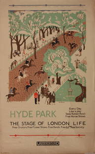
Sold2023Vintage PosterEdward Bawden (1903-1989) Hyde Park The Stage of London Life, original poster printed for the Underground (London Electric Railway) 1925 - 102 x 63 cm One the Bawden's first commercial design commissiSee Sold Price
Sold2020The Wonderground Map of London Town 1915 MacDonalLeslie MacDonald Gill (1884-1947), "The Wonderground Map of London Town," London, 1915. This highly detailed and eye-catching map was commissioned by the London Underground to entertain passengers waiSee Sold Price
Sold2022SOL LEWITT (1928-2007) R706 Map of London with the area between the underground stations at Marb...SOL LEWITT (1928-2007) R706 Map of London with the area between the underground stations at Marble Arch, St. James Park, Leicester Square, Waterloo Station, Pimlico, Sloane Sq., Knightsbridge, BayswatSee Sold Price
Sold2021Eight London Underground and Other Travel PostersEight London Underground and Other Travel Posters 20th Century including two Espana posters, Biarritz, and Mont-Revard, a Shop By Underground poster, From 430 to 1, By Tram to Hampton Court, and See TSee Sold Price
Sold2024Willem Blaeu, Map of The AmericasAmsterdam, 1617. Together with "Early Maps" by Tony Campbell, Abbeville Press and "The United States in Old Maps and Prints, Eduard Van Ermen. 3 pieces Sight size: 16-1/2"h x 22"w Overall: 23-1/2"h xSee Sold Price
Sold2016Cartier, Pair of Floral Stud Earrings with Diamonds,Platinum London, England, circa 1946 Monture by Cartier - French jewelry and watch manufacturer, established in 1847 in Paris Each signed with 'Cartier London' 2 old cut diamonds with a total weight oSee Sold Price
Sold2015Kingdom of IrelandJohn Speed (1552-1629). Engraved map. London: 1610 (1676). 17 1/4 x 22 inches. A rare, early printing of John Speed’s renowned map of Ireland. The map is decorated with a panel of costume figures deSee Sold Price
Sold2021FOUR-TIER GENERAL STORE CABINET.Wonderful old oak map cabinet sporting a older restoration that shows very nicely. These are getting more difficult to find, especially functional and with such a fantastic finish. Some very slight suSee Sold Price
Sold2022Faden Map of the Battle of Hobkirk's Kill, Revolutionary War, 1781FADEN, William (1749 – 1836). Sketch of the Battle of Hobkirks Hill, near Camden on the 25th April, 1781. Engraved map. London: Faden, Aug. 1, 1783. 21 3/4" x 15 1/8" sheet. This RevolutionarySee Sold Price
Sold2023Leslie MacDonald Gill (1884-1947) 'The Wonderground Map of London Town' c. 1924England, 20th century. Printed and Published by the Westminster Press, 11 Henrietta Street, Covent Garden, [1927]. Pictorial map printed in full color, 29” x 36.5” plus margins. The map waSee Sold Price
Sold2022Booth, Charles Labour and Life of the PeopleBooth, Charles Labour and Life of the People Volume I: East London. Second Edition. With a Coloured Map. [Together with:] Volume II: London Continued. With Maps and Appendix under a Separate Cover. LoSee Sold Price
Sold2016ASTER BRITISH RAILWAYS A4, SIR NIGEL GRESLEYELO Aster; German; B.R. A4; London Northeastern Railway (L.N.E.R.) 4-6-2-; Sir Nigel Gresley; No. 60007; 1 Gauge; Engine-18”; Tender-10"See Sold Price
Sold2023BING ADAMS LIVE STEAM LOCOMOTIVE & TENDERGerman, circa 1910, a Bing Adams 4-4-0 steam locomotive & tender in three gauge, both showing original paint & markings for the London & South Western Railway, the underside of the locomotive carriageSee Sold Price
Sold2022Brassier A Survey of Lake ChamplainWilliam Brassier "A Survey of Lake Champlain", Sayer and Bennett, London, 1776 hand-colored map, plate size 26 1/2" x 19 1/4"See Sold Price
Sold2024Map of the North Parts of America Claimed by France by Herman Moll (London, 1720)Map of the North Parts of America Claimed by France by Herman Moll (London, 1720) "A New Map of the North Parts of America claimed by France under ye Names of Louisiana, Mississippi, Canada, and New FSee Sold Price
Sold2016LeRoy Neiman (American, 1921-2012) Thomas A. BecLeRoy Neiman (American, 1921-2012)Thomas A. Becket Gym, Old Kent Road, London,See Sold Price
Sold2022(BRITISH EMPIRE.) George Philip & Son, Ltd.; and The London Geographical Institute. Navy League Map(BRITISH EMPIRE.) George Philip & Son, Ltd.; and The London Geographical Institute. Navy League Map of the British Empire. Oversize chromolithograph map of the world delineating early 20th-century BriSee Sold Price
Sold2017Massive live steam London and North Eastern RailwayMassive live steam London and North Eastern Railway train locomotive and tender, inscribed John Tierney maker Cranford Wks, with a placard inscribed London Steam Age - Manchester, with a 2-6-4 profileSee Sold Price
Sold2017Frank H Mason (1876-1965) Cruden Bay Travel by LNER,Frank H Mason (1876-1965) Cruden Bay Travel by LNER, original poster printed for the London and North Eastern Railway by Chorley & Pickersgill c. 1930 - 102 x 127 cmSee Sold Price
Sold2017Frank Newbould (1887-1951) Vienna via Harwich Twice aFrank Newbould (1887-1951) Vienna via Harwich Twice a day, original poster printed for the London and North Eastern Railway by McCorquodale c. 1925 - 102 x 127 cmSee Sold Price
3 days LeftKinghams AuctioneersJohn Speed (British, 1552-1629), map of Buckingham (1610), coloured engraving, published by George£40
Jun 07Freeman's | HindmanMURCHISON, Roderick Impey, Sir. The Silurian System. 1839. COMPLETE WITH VERY RARE HAND-COLORED$1,500
May 30NY Elizabeth 1792 OLD INDIA HISTORY ANTIQUE ILLUSTRATED WITH MAPS OF THE EIGHTEENTH CENTURY IN FRENCH$50
May 29Richard L. Edwards AuctioneeringLot of (3) 1965 Old London Coins - Varying Conditions - Al Kaline$1
18 hrs LeftThomaston Place Auction GalleriesCOLLECTION OF TRAVEL EPHEMERA, BROCHURES, BOOKLETS, MAPS 1900-1950$100
Jun 29JM Hobby Supply and Railroad Artifact AuctionsMetropolitan West Side Elevated RY Adlake Reliable Lantern$80(1 bid)
BonhamsA Rare 1822 Pattern British Officer's Sword Of The Spanish Auxiliary Legion, Reign Of Queen Isab...£380(1 bid)
Jun 07Freeman's | Hindman[MAP]. TODESCHI, Pietro. [Nova et Acurata Totius Americae Tabula auct. G.I. Blaeu] America quarta$5,000


![LONDON UNDERGROUND tube map diagram plan. First STINGEMORE edition 1925: TITLE/CONTENT OF MAP: Underground Railways of London [694 11.5.25] This is the first edition of an Underground geographic map designed by F H Stingemore. It is one of the first designs not to show any](https://p1.liveauctioneers.com/5584/263211/137236971_1_x.jpg?height=310&quality=70&version=1664917902)


![Leslie MacDonald Gill (1884-1947) 'The Wonderground Map of London Town' c. 1924: England, 20th century. Printed and Published by the Westminster Press, 11 Henrietta Street, Covent Garden, [1927]. Pictorial map printed in full color, 29” x 36.5” plus margins. The map wa](https://p1.liveauctioneers.com/7899/310285/166001628_1_x.jpg?height=310&quality=70&version=1700492487)
![Booth, Charles Labour and Life of the People: Booth, Charles Labour and Life of the People Volume I: East London. Second Edition. With a Coloured Map. [Together with:] Volume II: London Continued. With Maps and Appendix under a Separate Cover. Lo](https://p1.liveauctioneers.com/94/251108/130828910_1_x.jpg?height=310&quality=70&version=1655281539)


![[LONDON] RELICS OF OLD LONDON. LOT OF 8 TOGETHER (1 of 9)](https://p1.liveauctioneers.com/8124/329546/177689815_1_x.jpg?height=282&quality=70&version=1715469494)


![[MAP]. SPEED, John. A New Mappe of the Romane Empire. 1676. (1 of 2)](https://p1.liveauctioneers.com/197/329395/177650541_1_x.jpg?height=282&quality=70&version=1715364962)


![[MAP]. TODESCHI, Pietro. [Nova et Acurata Totius Americae Tabula auct. G.I. Blaeu] America quarta (1 of 1)](https://p1.liveauctioneers.com/197/329395/177650542_1_x.jpg?height=282&quality=70&version=1715364962)