Sold2018LONDON. Vintage Underground / Tube map 1933 old vintageTITLE/CONTENT OF MAP: 'Map of the Underground Railways of London' DATE: 1933 IMAGE SIZE: Approx 18.5 x 30.5cm, 7.25 x 12 inches (Medium) TYPE: Colour vintage street atlas map CONDITION: Good; suitableSee Sold Price
Sold2023Rare Vintage Old-Lager Keg Novelty Four Tube RadioRare Vintage Old-Lager Keg Novelty Four Tube RadioVintage 1933 Old-Lager Keg 4 tube radio with its original thick oak staves. Barrel shaped keg made to look like a real oak keg with four metal strapsSee Sold Price
Sold2023PORT OF SPAIN. Vintage map. Trinidad. West Indies. Caribbean 1927 oldPart of Port of Spain, Trinidad' by Sifton, Praed & Co. Ltd, St. James's St. London S.W. (1927). Vintage map, 17.5 x 14.5cm, 6.75 x 5.5 inches; Please note that this is a folding map. TITLE/CONTENT OFSee Sold Price
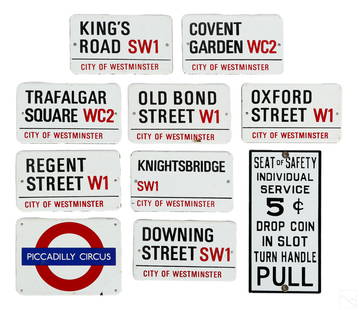
Sold2022Garnier & Co 10 Enameled Metal London Street SignsAn estate collection with 10 enameled metal street nameplate signs, including nine (9) vintage mid 20th Century City of Westminster (London) street and London Underground (subway tube) station signs,See Sold Price
Sold2023Vintage PosterClifford and Rosemary Ellis (1907-1998) Wood The busy Woodpecker, original poster printed for London Underground by Baynard Pres 1933 - 102 x 64 cmSee Sold Price
Sold2022LONDON UNDERGROUND tube map diagram plan. First STINGEMORE edition 1925TITLE/CONTENT OF MAP: Underground Railways of London [694 11.5.25] This is the first edition of an Underground geographic map designed by F H Stingemore. It is one of the first designs not to show anySee Sold Price
Sold2023LONDON UNDERGROUND LINE CAR TUBE MAP DIAGRAMSLONDON UNDERGROUND LINE CAR TUBE MAP DIAGRAMS Three London Underground Line Car diagrams, including Northern Line, Central Line, and District Line (unframed). Framed pieces are adhered to foam boardSee Sold Price
Sold20231916 OLD VINTAGE MAP, CITY of LIMA Ohio OH & VICINITY by E. J. VEASEY, JR.1916 OLD VINTAGE MAP, CITY of LIMA Ohio OH & VICINITY by E. J. VEASEY, JR. 1916 OLD VINTAGE MAP, CITY of LIMA Ohio OH & VICINITY by E. J. VEASEY, JR. Description 1916 Old Vintage Map: CITY OF LIMA OHISee Sold Price
Sold2023West Indies and Central America. Caribbean. STANFORD c1925 old vintage mapTitle: West Indies and Central America. Caribbean. STANFORD c1925 old vintage map Description: West Indies and Central America' by Edward Stanford Ltd. (The map is undated; we estimate publication atSee Sold Price
Sold2022World War 1. Battle of Jutland 30-31 May 1916 movements 1959 old vintage mapTITLE/CONTENT OF MAP: 'Battle of Jutland - Movements on 30-31 May 1916 // Battle of Jutland Battle Cruiser Action 1530-1730, 31 May // Battle of Jutland main Engagement 1730-2100, 31 may' DATE PRINTEDSee Sold Price
Sold2023South America. Second World War 1942 old vintage map plan chartTitle: South America. Second World War 1942 old vintage map plan chart Description: South America' by George Philip & Son (1942). Vintage colour map, 27.5 x 22.0cm, 10.75 x 8.5 inches Product InformatSee Sold Price
Sold2023South America. Second World War 1942 old vintage map plan chartTitle: South America. Second World War 1942 old vintage map plan chart Description: South America' by George Philip & Son (1942). Vintage colour map, 27.5 x 22.0cm, 10.75 x 8.5 inches Product InformatSee Sold Price
Sold2024Pacific Ocean. BARTHOLOMEW 1949 old vintage map plan chartTITLE/CONTENT OF MAP: 'Pacific Ocean' DATE PRINTED: 1949 IMAGE SIZE: Approx 18.5 x 22.5cm, 7.25 x 8.75 inches (Medium); Please note that this is a folding map. TYPE: Vintage colour atlas map CONDITIONSee Sold Price
Sold2024West Indies & Caribbean. Panama Canal. Relief. THE TIMES 1922 old vintage mapTITLE/CONTENT OF MAP: 'The West Indies' DATE PRINTED: 1922 IMAGE SIZE: Approx 44.5 x 57.5cm, 17.5 x 22.5 inches (Large); Please note that this is a folding map. TYPE: Antique atlas map CONDITION: GoodSee Sold Price
Sold2023ASIA. The Railroads of Asia in 1914 1948 old vintage map plan chartThe Railroads of Asia in 1914' by Drawn by Walter Y. Cox (1948). Vintage map. This map was published in 1948 but it may depict an earlier representation of the area shown dated 1914 and the mapmaker mSee Sold Price
Sold2024SOUTH AMERICA. Political. BARTHOLOMEW 1924 old vintage map plan chartTITLE/CONTENT OF MAP: 'South America; Inset map of Continuation of Southern Part' DATE PRINTED: 1924 IMAGE SIZE: Approx 44.5 x 34.0cm, 17.5 x 13.25 inches (Large); Please note that this is a folding mSee Sold Price
Sold2022ASIA.Asien;Vegetation 1958 old vintage map plan chartTITLE/CONTENT OF MAP: 'Asien; Vegetation' DATE PRINTED: 1958 IMAGE SIZE: Approx 18.5 x 31.0cm, 7.25 x 12.25 inches (Medium) TYPE: Vintage colour map; Scale 1:60,000,000 CONDITION: Good; suitable for fSee Sold Price
Sold2022Long Island Pictorial MapA Map of Long Island. Courtland Smith. Billboard Barn: 1933. Vintage map. Scattered creases. Overall 22 1/2" x 30".See Sold Price
Sold2023HAVANA. Vintage town plan. Railways & streetcar lines. Cuba. Caribbean 1923 mapHavana' by Sifton, Praed & Co. Ltd, St. James's St. London S.W. (1923). Vintage map, 18.5 x 15.0cm, 7.25 x 6 inches; Please note that this is a folding map. Additional Information: CAPTION PRINTED BELSee Sold Price
Sold2023L'Africa. DE ROSSI / SANSON 1677 old antique vintage map plan chartTITLE/CONTENT OF MAP: L'Africa [Africa] DATE PRINTED: 1677 IMAGE SIZE: Approx 42.5 x 57.0cm, 16.75 x 22.25 inches (Large) TYPE: Antique 17th century folio atlas map CONDITION: Good; suitable for framiSee Sold Price
Sold2024L'Europa. Europe. DE ROSSI 1677 old antique vintage map plan chartTITLE/CONTENT OF MAP: L'Europa [Europe] DATE PRINTED: 1677 IMAGE SIZE: Approx 44.0 x 56.5cm, 17.25 x 22.25 inches (Large) TYPE: Antique 17th century folio atlas map CONDITION: Good; suitable for framiSee Sold Price
Sold2023L'Europe. Europe. BONNE 1780 old antique vintage map plan chartTITLE/CONTENT OF MAP: 'L'Europe' A map of Europe DATE PRINTED: 1780 IMAGE SIZE: Approx 23.0 x 34.0cm, 9 x 13.5 inches (Large); Please note that this is a folding map. TYPE: Antique copperplate engraveSee Sold Price
2022Havana. Cuba 1885 old antique vintage map plan chartTITLE/CONTENT OF MAP: 'Havana' DATE PRINTED: 1885 IMAGE SIZE: Approx 22.5 x 29.0cm, 8.75 x 11.25 inches (Large); Please note that this is a folding map. TYPE: Antique colour map; Scale 1:14,000 CONDITSee Sold Price
Sold2023HOLY ROMAN EMPIRE. Europe in 1360 1902 old antique vintage map plan chartTITLE/CONTENT OF MAP: 'Europe in 1360' DATE PRINTED: 1902 IMAGE SIZE: Approx 25.0 x 33.5cm, 10 x 13.25 inches (Large) TYPE: Antique colour map. This map was published in 1902 but it may depict an earlSee Sold Price


![LONDON UNDERGROUND tube map diagram plan. First STINGEMORE edition 1925: TITLE/CONTENT OF MAP: Underground Railways of London [694 11.5.25] This is the first edition of an Underground geographic map designed by F H Stingemore. It is one of the first designs not to show any](https://p1.liveauctioneers.com/5584/263211/137236971_1_x.jpg?height=310&quality=70&version=1664917902)


![L'Africa. DE ROSSI / SANSON 1677 old antique vintage map plan chart: TITLE/CONTENT OF MAP: L'Africa [Africa] DATE PRINTED: 1677 IMAGE SIZE: Approx 42.5 x 57.0cm, 16.75 x 22.25 inches (Large) TYPE: Antique 17th century folio atlas map CONDITION: Good; suitable for frami](https://p1.liveauctioneers.com/5584/308981/165185503_1_x.jpg?height=310&quality=70&version=1699996168)
![L'Europa. Europe. DE ROSSI 1677 old antique vintage map plan chart: TITLE/CONTENT OF MAP: L'Europa [Europe] DATE PRINTED: 1677 IMAGE SIZE: Approx 44.0 x 56.5cm, 17.25 x 22.25 inches (Large) TYPE: Antique 17th century folio atlas map CONDITION: Good; suitable for frami](https://p1.liveauctioneers.com/5584/322790/173578184_1_x.jpg?height=310&quality=70&version=1710881198)


