Sold2022(AFRICA.) Abraham Ortelius. Two double-page engraved maps of northern Africa in original hand-color.(AFRICA.) Abraham Ortelius. Two double-page engraved maps of northern Africa in original hand-color. Antwerp, 1603 - Fessae, et Marocchi Regna Africae Celeberr. (Canary Islands, Morocco, Straits of GiSee Sold Price
Sold2022Morocco, partly colored copper engraved map "Statuum Marocca Norum", by JohMorocco, partly colored copper engraved map "Statuum Marocca Norum", by Johann Christoph Homann, Nuremberg, 1728, the map shows Morocco with the offshore Canary Islands, top left many-figured cartouchSee Sold Price
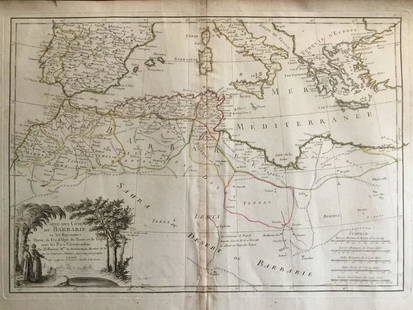
Sold2017Bellin Map of West North Africa & Canary Islands, 17501750 Bellin Map of Western North Africa and Canary Islands -- Coste Occidentale D'Afrique. This is Bellin's map of the northwestern coast of Africa. It covers from the Strait of Gibraltar to just beloSee Sold Price
Sold2018Canary Islands & Morocco C1945 Rare Manuscript Map. RGSManuscript Map, Rare Printers Proof (Unique) Later Published in "The Geographical Journal" by the RGS. With margin pencil annotations by the Cartographer. On very thick paper. Paper Size: 19 x 15 inchSee Sold Price
Sold2020Islands of Italy and Malta. 1762 by Homann HeirsTitle: Islands of Italy and Malta. 1762 by Homann Heirs Date/Period: 1762 Materials: Copperplate engraved Size: 24 x 20 1/2" Shows Sicily, Sardinia, Corsica and Malta, along with the southern boot ofSee Sold Price
Sold20226 Tribal Clubs And A TotemVarious Locations, circa late 19th - early 20th century. A nice group pf clubs and staffs from Australia, Samoa, Africa and Solomon Islands. The N.W. Coast totem likely mid 20th century. Dimensions: gSee Sold Price
2024COLONIAL AFRICA.British German French Madeira Canaries Mauritius.BACON 1893 mapCAPTION PRINTED BELOW PICTURE: 'Africa; Inset maps of Madeira; Canary Islands; Mauritius' DATE PRINTED: 1893 IMAGE SIZE: Approx 49.0 x 32.5cm, 19.25 x 12.75 inches (Large); Please note that this is aSee Sold Price
Sold2018RGS - Geographical Journal C1945 Lot 16 Manuscript MapsIncl Canada, Isle of Wight, Burma, Norway, Gough Island, Fiji, Tibet, Leeward Islands, South Africa, Antarctic, Uganda, Morocco, Canada, and Brazil. Lot of 16 Hand Drawn Manuscript (one is printed) AlSee Sold Price
Sold2022Afrique. Partie du Désert de Sahara #6. Canary Islands. VANDERMAELEN 1827 mapTITLE/CONTENT OF MAP: 'Afrique - Partie du Désert de Sahara - No. 6' The eastern Canary islands of Fuerteventura and Lanzarote, part of Western Sahara and southern Morocco DATE PRINTED: 1827 IMAGSee Sold Price
Sold2020Barbary coat. North west Africa. Morocco, Tunisia,Title: Barbary coat. North west Africa. Morocco, Tunisia, Algeria and Libya.. Date/Period: 1762 - 1771 Materials: Copperplate engraved Size: 20”x 14 1/2”. Barbary coast, shows North African countrSee Sold Price
Sold2020Franz Xaver Bergmann Canary Island lizard, #4133Franz Xaver Bergmann (1861-1936) Canary Island lizard, #4133 Vienna, Austria cold-painted bronze impressed marks 9 1/4"w x 7 1/2"d x 2 11/16"hSee Sold Price
Sold2023OSCAR DOMINGUEZ - OIL PAINTING ON CANVAS - (1906 - 1957)Description: Oscar Dominguez (San Cristóbal de La Laguna, January 3, 1906 – Paris, December 31, 1957) was a surrealist painter from the Canary Islands belonging to the generation of '27.MeasSee Sold Price
2023OSCAR DOMINGUEZ - OIL PAINTING ON CANVAS - (1906 - 1957)Description: Oscar Dominguez (San Cristóbal de La Laguna, January 3, 1906 – Paris, December 31, 1957) was a surrealist painter from the Canary Islands belonging to the generation of '27.MeasSee Sold Price
Sold2020Nelson LinesRegular Fortnightly mail, Passenger and / Freight Service / London and Boulogne / to Spain, Canary Islands/ Brazil, Uruguay and Argentina ca. 1920s-1930s artist's initials AW printed in image; prinSee Sold Price
Sold2023(8) ETCHINGS, UNFRAMED, ALL BUT ONE BY CADWALLADER LINCOLN WASHBURN (MN/CA, 1866-1965)Including: Old Man in Chair, after Fortuny; Vista of Grenada; Head of Old Man; A Franciscan; Money Lender; Bearded Man with Cap; Old Man of Tenerife, Canary Islands; PLUS Park by Geoffrey Heath WedgewSee Sold Price
Sold2015Haida Argillite Carved Pipe and StoneHaida Argillite Carved Pipe and Stone, pipe inscribed Queen Charlottes Island N.W. Coast America {length of pipe 6 3/4 inches}See Sold Price
Sold2021The America’s 1762 by Homann HeirsTitle: The America’s 1762 by Homann Heirs Date/Period: 1762 Materials: Copperplate engraved Size: 24 x 20 1/2 1762, by J. B. Homann & Homann Heirs, from "Atlas Homannianus Mathematico-Historice DeliSee Sold Price
Sold2021Italy 1762 by Homann HeirsTitle: Italy 1762 by Homann Heirs Date/Period: 1762 Materials: Copperplate engraved Size: 24 x 20 1/2" Description: A magnificent map of all of Italy. Shows Venetian territory’s in Dalmatia. CoSee Sold Price
Sold2023MAP: ANTIQUE 1737 JOHANN BAPTIST .B HOMANN- AFRICA SECUNDUM LEGITIMASDescription: Framed Antique 1737 - J.B HOMANN- AFRICA SECUNDUM LEGITIMAS. Johann Baptist Homann (20 March 1664 -1 July 1724) was a German geographer and cartographer, who also made maps of the AmericaSee Sold Price
Sold2023Morocco, North Africa, Possibly Wedding Sash or HizamMorocco, North Africa, possibly wedding sash or hizam, 19th or early 20th century, 12" x 60" PROVENANCE: From the estate of Dr. Philip Gould, New YorkSee Sold Price
Sold2020England and Wales 1762 by Homann HeirsTitle: England and Wales 1762 by Homann Heirs Date/Period: 1762 Materials: Copperplate engraved Size: 24 x 20 1/2" Nicely decorative map of England and Wales, shows the boundaries of the seven Anglo SSee Sold Price
Sold2020Scotland 1762 by Homann HeirsTitle: Scotland 1762 by Homann Heirs Date/Period: 1762 Materials: Copper plate engraved Size: 24 x 20 1/2" Description: 1762, by J. B. Homann & Homann Heirs, from "Atlas Homannianus Mathematico-HistorSee Sold Price
Sold2021Kingdom of Poland-Lithuania. 1762 by Homann HeirsTitle: Kingdom of Poland-Lithuania. 1762 by Homann Heirs Date/Period: 1762 Materials: Copperplate engraved Size: 24 x 20 1/2" Shows a massive Polish-Lithuania Commonwealth. Extends from Prussia to UkrSee Sold Price
Sold2020Northern South America, labeled peru. 1762, by HomannTitle: Northern South America, labeled peru. 1762, by Homann Heirs Date/Period: 1762 Materials: Copperplate engraved Size: 24 x 20 1/2" A beautiful map shows Peru and the countries of Brazil, all threSee Sold Price
3 days LeftJasper521723 Dampier Map of Voyages to Brazil, Australia and Eat Indies -- Voyage du Cap. Dampier a la N.$280
4 days LeftJasper52AFRICAN ISLANDS Mauritius Madagascar Madeira Canaries St Helena Socotra 1910 map$20
May 09Hunt and Peck Estate Services, Inc.Abraham Ortelius Map Of Fezza And Morocco Kingdom Of Africa Celeberrima$100
Featured3 days LeftJasper52RARE MAP, 1762, 15 Cities of the Safavid era Persian Empire by J. B. Homann$600