Sold20181887 Mitchell Map od Indian Territory -- IndianTitle/Content of Map: 1887 Mitchell Map od Indian Territory -- Indian Territory Date: 1887, Philadelphia Cartographer: S Mitchell Size: 11.6 x 14.5 in. A very nice map of the Indian Territories, but oSee Sold Price
Sold20201887 Map of Oklahoma and the Indian territoryAuthor: Watson Title: 1887 Map of Oklahoma and the Indian territory Medium: Ink on Paper Dimensions: 14.5"X11.5" Map of Oklahoma and the Indian territory dated 1887. Engraved and published by Watson iSee Sold Price
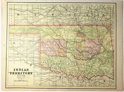
Sold20201887 Map of Oklahoma and the Indian TerritoryAuthor: Cram Title: 1887 Map of Oklahoma and the Indian Territory Medium: Ink on PaperDimensions: 14.5"X11" Map of Oklahoma and the Indian Territory dated 1887. Engraved and published by George Cram iSee Sold Price
Sold20201887 Map of Oklahoma and the Indian TerritoryAuthor: Watson Title: 1887 Map of Oklahoma and the Indian Territory Medium: Ink on Paper Dimensions: 16"X11.5" Map of Oklahoma and the Indian territory dated 1887. Engraved and published by Watson inSee Sold Price
Sold20201887 Map of Oklahoma and the Indian TerritoryAuthor: Cram Title: 1887 Map of Oklahoma and the Indian Territory Medium: Ink on Paper Dimensions: 14.5"X11" Description: Map of Oklahoma and the Indian territory dated 1887. Engraved and published bySee Sold Price
Sold2021Map of Indian Territory & KansasMap of Indian Territory Combined with Map of Kansas on Verso Color Map Dated: 19th century Dimensions: 10 x 6 1/2" Condition Report Good. TextSee Sold Price
Sold2022Texas, Indian Terr. and SW states, Steinwehr 1870Striking map from 1870 school atlas. Shows military posts, tribes, railroads, cities and towns in Texas, Arkansas, Mississippi, "Indian Territory," and Louisiana, and public lands. Printed color. MapSee Sold Price
Sold20231833 map of Mississippi shows Indian territory as half of stateAn important and historical map of Mississippi with counties named and in contrasting colors. This map is particularly important due to the rapidly changing American Indian situation in the northern pSee Sold Price
Sold2019AN VINTAGE MAP, "Texas and Indian Territory," SECONDAN VINTAGE MAP, "Texas and Indian Territory," SECOND QUARTER 20TH CENTURY, color engraving on paper, showing counties, cities, rail lines, and rivers. 13.25" x 10.125"See Sold Price
Sold2021Large Map of Oklahoma & Indian TerritoriesMap of Oklahoma & Indian Territories With map of New Mexico on verso Cartographer: George Franklin Cram Dated: Circa 1900 Type: Color LithographSee Sold Price
Sold20201887 Cram Map of Texas [verso] Indian Territory [verso]Title/Content of Map: 1887 Cram Map of Texas [verso] Indian Territory [verso] Arkansas -- Texas [verso] Indian Ty. [verso] Arkansas Date: 1887, Chicago Cartographer: G Cram Size: 12 X 17 in. This is aSee Sold Price
Sold2019AN ANTIQUE MAP, "Map of Oklahoma and Indian Territory,"AN ANTIQUE MAP, "Map of Oklahoma and Indian Territory," 1890-1892, color engraving on paper, copyrighted by Mast, Crowell & Kirkpatrick, with view of Beaver. 10.375" x 13" Note: Showing populations oSee Sold Price
Sold2018Map of Railroad and County “Indian Territory"Map of Railroad and County “Indian Territory" 22" x 28" Map of Railroad and County “Indian Territory" (Rare!) shows Indian occupied Lands – Reservation in color, not dated but 1880’s likelySee Sold Price
Sold20201887 Map of Indian NationsAuthor: Clare Title: 1887 Map of Indian Nations Medium: Ink on Paper Dimensions: 14"X11.5" Map dated 1887 part of Watson's General Atlas. Engraved by I.S. Clare it captures the Indian Nations territorSee Sold Price
Sold2022Contemporary Painting, Oil on CanvasContemporary Painting, Oil on Canvas, Multi Color Map of the World in Tile Style with Glossy Finish. 36" High, 48" WideSee Sold Price
Sold2020Indian Territory 1891Title/Content of Map: Indian Territory 1891 Date Printed: 1891 Material/Medium: Paper Size: approx 10.5x14.5 inches Additional Info: Cram's Atlas of the World. Geo. F. Cram, Chicago Reserve: $20.00 SSee Sold Price
Sold2023Non Native America Navajo Sterling Silver Multi-Color Non Indian Head Ring.This is a Non Native America Navajo Sterling Silver Multi-Color Indian Head Ring. Ring size: 9.50.See Sold Price
Sold2020Indian Territory 1897Title/Content of Map: Indian Territory 1897 Date Printed: 1897 Material/Medium: paper Size: approx. 11x 13.5 inches Additional Info: Cram's Universal Atlas Reserve: $30.00 Shipping: Domestic: Flat-ratSee Sold Price
Sold2021Government map of Indian TerritoriesHeading: (Indian Territory) Author: Dinsmore, A. F., Lowe, R.P., Naylor, William, Cartographers Title: Indian Territory. Department of The Interior General Land Office. Hon. Thomas H. Carter, CommissiSee Sold Price
Sold20181890 Census Office Map of Indian Territory and OklahomaTitle/Content of Map: 1890 Census Office Map of Indian Territory and Oklahoma -- Map of Indian Territory and Oklahoma Date: 1890, Washington Cartographer: General Land Office / Census Office Size: 22.See Sold Price
Sold202119th C. Map of Indian Territory & 20th C. Kachina**Originally Listed At $300** Map: "Map of Indian Territory Drawn and Engraved on Copper Plate Expressly for Johnson's Cyclopedia" - Volume IV New York - A.J. Johnson Company, ca. 1880 to 1894. FigureSee Sold Price
Sold2021Scarce map of Indian Territory, 1886Most likely the final map of Indian Territory produced by the Colton firm. Map is colored by Indian Nations, and shows a massive Cheyennes and Arapahoes Nation at the top. Over two dozen Native AmericSee Sold Price
Sold2020Map of Indian TerritoryTitle/Content of Map: Map of Indian Territory Date: 1899 Cartographer: U.S. GEOLOGICAL SURVEY Publisher: U.S.G.S. Size: 32.5Height - 29.5Width showing distribution of woodland. Compiled under the direSee Sold Price
Sold2016Map of Indian Territory and Oklahoma, J. Bein 1890Title: Map of Indian Territory and Oklahoma Subject: Oklahoma Maker: J. Bein Date: 1890, New York Size: 22.5 x 29.5 inches Map of the Indian Territory showing areas ceded to various tribes, each withSee Sold Price
Jun 12Dan Morphy AuctionsPLATE CXIII. MAP OF INDIAN TERRITORY SHOWING DISTRIBUTION OF WOODLAND” FROM THE TWENTY-FIRST$100
Jun 12Dan Morphy AuctionsMAP OF THE CHOCTAW NATION, INDIAN TERRITORY - COAL AND ASPHALT SEGREGATION 1903$150
Jun 12Dan Morphy AuctionsMAP OF THE CHOCTAW NATION, INDIAN TERRITORY - COAL AND ASPHALT SEGREGATION 1903$100
3 days LeftPacific Auction HouseNative America Zuni Sterling Silver Multi-Color Stone Inlay Bracelet Cuff By H.Smith.$70(5 bids)
3 days LeftPacific Auction HouseNative America Navajo Sterling Silver Multi-Color Stone Santra Domingo Necklace By Susie Deal.$20(1 bid)
3 days LeftPacific Auction HouseNative America Navajo Sterling Silver Multi-Color Stone Cuff Bracelet Link By Clifford Lewis.$20
Jun 01Black Hills Curio CompanyOld Native American Indian Painted Pottery Vase Flower Design repair crack N.Mex$50
3 days LeftPacific Auction HouseNative America Zuni Sterling Silver Multi-Color Stone Inlay Necklace / Earring's / Bracelet & Ring$20(1 bid)
3 days LeftPacific Auction HouseNative America Navajo Sterling Silver Multi-Color Inlay Ring By A.T.$20
1 day LeftPasargad Auctions6 LA Multi Color Fine Hand Knotted Persian silk & wool Habibian Nain 6'9" X 10'$3,500
1 day LeftPasargad AuctionsMulti Color Fine Hand Knotted Persian silk & wool Habibian Nain 8'6" x 11'6'$4,500
3 days LeftPacific Auction HouseNative America Zuni Sterling Silver Multi-Color Stone Inlay Bracelet By L.S.$20(1 bid)
3 days LeftPacific Auction HouseNative America Navajo Sterling Silver Multi-Color Stone Beaded Necklace By J.F.$20
3 days LeftPacific Auction HouseNative America Zuni Sterling Silver Multi-Color Stone Inlay Eagle Dancer Bracelet By Jonathan$20


![1887 Cram Map of Texas [verso] Indian Territory [verso]: Title/Content of Map: 1887 Cram Map of Texas [verso] Indian Territory [verso] Arkansas -- Texas [verso] Indian Ty. [verso] Arkansas Date: 1887, Chicago Cartographer: G Cram Size: 12 X 17 in. This is a](https://p1.liveauctioneers.com/5584/164510/83043299_1_x.jpg?height=310&quality=70&version=1585094571)