Sold2023Nautical chart of Chequetan harbor near Acapulco, by the English pirate AnsonTitle: Nautical chart of Chequetan harbor near Acapulco, by the English pirate Anson Date/Period: 1749 Materials: Copper plate engraved Size: 15 1/2 x 10" Nautical chart of Chequetan or Seguaaneo, harSee Sold Price
Sold2022Nautical chart of Petatian near Acapulco by the English pirate Anson, 1749Title: Nautical chart of Petatian near Acapulco by the English pirate Anson, 1749 Date/Period: 1749 Materials: Copper plate engraved Size: 15 1/2 x 10” Nautical chart of Petatian, near Acapulco,See Sold Price
Sold2022Nautical chart of Acapulco by the English pirate Anson, 1749Title: Nautical chart of Acapulco by the English pirate Anson, 1749 Date/Period: 1749 Materials: Copper plate engraved Size: 10 x 7 1/4 “ Nautical chart of the port of Acapulco, Mexico. By the ESee Sold Price
Sold2022Nautical View of Petatian near Acapulco, by the English pirate Anson. 1749Title: Nautical View of Petatian near Acapulco, by the English pirate Anson. 1749 Date/Period: 1749 Materials: Copper plate engraved Size: 15 1/2 x 10” Nautical view of Petatian and rocks calledSee Sold Price
Sold2022Nautical chart of the attack by five ships on Acapulco, by the English pirate Anson. 1749Title: Nautical chart of the attack by five ships on Acapulco, by the English pirate Anson. 1749 Date/Period: 1749 Materials: Copper plate engraved Size: 15 1/2 x 10” Nautical chart of the attacSee Sold Price
Sold2023Nautical Chart of Manila by the English pirate Anson. 1749Title: Nautical Chart of Manila by the English pirate Anson. 1749 Date/Period: 1749 Materials: Copper plate engraved Size: 10 x 9 3/4” Nautical chart of Manila, Philippines. Showing the city andSee Sold Price
Sold2022Nautical chart of Coiba island, Panama, by the English pirate Anson. 1749Title: Nautical chart of Coiba island, Panama, by the English pirate Anson. 1749 Date/Period: 1749 Materials: Copper plate engraved Size: 15 1/2 x 10” Nautical chart of the east end of Quibo (CoSee Sold Price
Sold2022Nautical chart of the Pacific Ocean, showing the route of the famous Spanish treasure’ManilaTitle: Nautical chart of the Pacific Ocean, showing the route of the famous Spanish treasure’Manila Galleons’, by the English pirate Anson. 1749 Date/Period: 1749 Materials: Copper plateSee Sold Price
Sold2022Nautical chart of Juan Fernandez island. (Robinson Cruseo is) by the English pirate Anson, 1749Title: Nautical chart of Juan Fernandez island. (Robinson Cruseo is) by the English pirate Anson, 1749 Date/Period: 1749 Materials: Copper plate engraved Size: 15 1/2 x 10” Nautical chart of JuaSee Sold Price
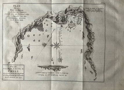
Sold2022Nautical chart of a unidentified bay in Chile. By the English pirate Anson 1749Title: Nautical chart of a unidentified bay in Chile. By the English pirate Anson 1749 Date/Period: 1749 Materials: Copper plate engraved Size: 13 1/2 x 9 3/4” Nautical chart of a unidentified BSee Sold Price
Sold2023Antique Nautical Chart of the Philippines: Manila Galleons Route by English Pirate George Anson,Title: Antique Nautical Chart of the Philippines: Manila Galleons Route by English Pirate George Anson, 1749 Date/Period: 1749 Materials: Copper plate engravedSize: 21 1/4 x 16 3/4”. Step into tSee Sold Price
Sold2023Antique Nautical Chart of Juan Fernandez Island: Northeast Side by English Pirate George Anson,1749Title: Antique Nautical Chart of Juan Fernandez Island: Northeast Side by English Pirate George Anson,1749 Date/Period: 1749 Materials: Copperplate engraved Size: 15 1/2 x 10” Explore the legendSee Sold Price
Sold2022View of Acapulco and nearby Zihuatanejo, Mexico, by the English pirate Anson. 1749Title: View of Acapulco and nearby Zihuatanejo, Mexico, by the English pirate Anson. 1749 Date/Period: 1749 Materials: Copper plate engraved Size: 15 1/2 x 10” View of Acapulco and nearby ChequeSee Sold Price
Sold2020TWO FRAMED ENGLISH NAUTICAL MAPScomprising 'Harwich Harbor' and 'Great Circle Sailing Chart of the North Atlantic Ocean' Harwich Harbor: 27 x 52 inches sight; the other, 32 1/4 x 38 1/2 inches sightSee Sold Price
2017Antique Nautical Chart of San Francisco Harbor, 1885Map: 1885 British Admiralty Chart of San Francisco Harbor -- North America; West Coast; San Francisco Harbour from United States Coast Survey 1877 Date Printed: 1885, London Cartographer: British AdmiSee Sold Price
Sold2016Original Imray & Son S. America Coast Chart, 1877Nautical Chart of South American coast, between Rio de la Plata and Valparaiso. Details include Cape Horn Islands, South Shetlands, Falklands, Southern tip of South American coast including Chile andSee Sold Price
Sold2022John Syer (English, 1815 - 1885) oil on canvas, continental marine scene, depicts working boats nearJohn Syer (English, 1815 - 1885) oil on canvas, continental marine scene, depicts working boats near harbor, figures stand in shallow water, setting sun, framed in ornate gilt wood frame, with some arSee Sold Price
Sold2021VINTAGE BOWDITCH NAUTICAL MAP OF SALEM 30"VINTAGE BOWDITCH " CHART OF THE HARBORS OF SALEM MARBLEHEAD BEVERLY AND MANCHESTER COLLECTIBLE MARITIME NAUTICAL MAP CARTOGRAPHY MASS MASSACHUSETTS-25" X 30" APPROX TO FRAME-VERY GOOD CONDITION, WEARSee Sold Price
Sold2022British Royal Navy Minesweeper ChainDouble link of genuine English navy stud link magnetic brass mine sweeper chain that has been meticulously polished and lacquered, Great nautical relic. Looks like solid 8 gold. 10 xl x 4 w. 7 lbs.See Sold Price
Sold2020Des Barres Map of NY Harbor*** START PRICE IS THE RESERVE *** [America] DES BARRES, Joseph Frederick Wallet (1729-1824). A Chart of New York Harbour with the Soundings Views of Land Marks and Nautical directions for the Use ofSee Sold Price
Sold2021Anthony Thieme 1888-1954 Seascape Harbor PaintingAnthony Thieme (American, 1888-1954). Antique oil painting on canvas board. A misty, coastal nautical landscape with boats and dock. Artist signature lower right corner. Antique English "Royal InstituSee Sold Price
Sold2024TWO NAUTICAL CHARTSEast Coast of North America 1870, 47 inches by 33 inches. George W. Eldridge Chart of Kennebec River to Deer Isle, 1916, 35 inches by 59 inches. Together with blue print of the US Merrimack and an 183See Sold Price
2022Cartier Panthere 8057916 18k Gold & Diamond Bezel WatchCartier Panthere 8057916 18k Yellow Gold & Diamond Bezel Ladies Quartz Watch. CONDITION DETAILS CHART:*NEAR MINT: LIKE NEW WITH NO NOTED FLAWS*EXCELLENT: NORMAL WEAR AS EXPECTED DUE TO AGE, BUT NOTHINSee Sold Price
Sold2020Japan. Seto inner sea.Japan. Seto inner sea.XIXth century, [Edo period]Manuscript nautical chart, mm. 3300 x 5750. Very rare commercial nautical chart engraved on wood with the commercial nautical routes highlighted in redSee Sold Price
May 11Boston Harbor Auctions Ship Model Caroline, The Royal Yacht Of George II and George III$1,600(2 bids)


![Des Barres Map of NY Harbor: *** START PRICE IS THE RESERVE *** [America] DES BARRES, Joseph Frederick Wallet (1729-1824). A Chart of New York Harbour with the Soundings Views of Land Marks and Nautical directions for the Use of](https://p1.liveauctioneers.com/1968/163248/82424572_1_x.jpg?height=310&quality=70&version=1583340284)


![Japan. Seto inner sea.: Japan. Seto inner sea.XIXth century, [Edo period]Manuscript nautical chart, mm. 3300 x 5750. Very rare commercial nautical chart engraved on wood with the commercial nautical routes highlighted in red](https://p1.liveauctioneers.com/3336/174968/90450870_1_x.jpg?height=310&quality=70&version=1600527463)


