Sold2022Pictorial Map Vintage GameThe Wide World by Henrik van Loon. Pictorial world map board game. Ship, plane game pieces, cards, instructions, in bpx. Parker Brothers. Cartography collectible.14" x 20" x 2". Box as found.See Sold Price
Sold2022Islands Bahamas Vintage Pictorial Map Poster GicleeIslands Bahamas Vintage Pictorial Map Poster Giclee Canvas Print 40x35See Sold Price
Sold2017Vintage Pictorial Map of Newport, RI & Ten Mile DriveMap: Pictorial Map of Newport, RI and Ten Mile Drive Maker: Mount Hope Bridge Corporation Publication Date: 1937 Geographic Area: United States Body of Water: Narragansett Bay ConditoiN: Very good. ASee Sold Price
Sold2017Putnam: Vintage Pictorial Map of South California, 1963Title/Content of Map: 1963 Putnam Pictorial Map of Southern California -- Ride the Roads to Romance along the Gold Coast thru the Sunshine Empire of Southern California Date Printed: 1963, San BernardSee Sold Price
Sold2017White: Vintage Pictorial Map of Oahu, 1930Map: 1930 White Map of Oahu -- The Island of Oahu Cartographer: R White Year / Place: 1930 Map Dimensions: 11.3 x 14.6 in. Condition: Very Good. Nice colored impression. Very little toning. A very attSee Sold Price
Sold2017Vintage Pictorial Map of San Francisco, 1947Title/Content of Map: 1947 Pictorial Map of San Francisco -- 49 Mile Scenic Drive, San Francisco Date Printed: 1947, San Francisco Cartographer: San Francisco Downtown Association Size: 9 X 12 in. A vSee Sold Price
Sold2022Tampa Vintage Pictorial MapPoints of Interest in and Around Tampa Florida, Hillsborough County. Mid 20th Century. Folds as issued. 18 1/4" x 12".See Sold Price
Sold2017PanAm Vintage Pictorial Map of Australia & Oceania 1960Title/Content of Map: 1960 PanAm Pictorial Map of Australia and Oceania -- Australie Oceanie Date Printed: 1960 Cartographer: J Liozu / PanAm Size: 11.8 x 9 in. Very attractive pictorial map of AustraSee Sold Price
Sold2017PanAm: Vintage Pictorial Map of Asia, 1960Map: 1960 PanAm Pictorial Map of Asia -- Asiae Cartographer: J Liozu / PanAm Year / Place: 1960 Map Dimensions: 11.8 x 9 in. Condition: Very Good. Nice, sharp image and colors.Later center-fold. VerySee Sold Price
Sold2024E.O. Goldbeck (1892-1986), Texas Oil Field PhotoVintage pictorial map of oilfields of Burkburnett, Texas, dated April 15th, 1919, marked #2, photographed by Charles Steele, framed sight: 8.5 x 60.5 in., frame: 13.5 x 65.5 in. Provenance: PropertySee Sold Price
Sold2023Vintage Needlepoint Pictorial Map of Nantucket, 20th centuryVintage Needlepoint Pictorial Map of Nantucket, 20th century, depicting Nantucket Sound, Great Point, Sankaty Head, The Old Mill, and the Oldest House, signed upon reverse, "1992 To Kit & TonSee Sold Price
Sold2021Vintage USA Map Pictorial Screen DividerVintage USA Map Pictorial screen divider, exterior of screen decorated with a vintage travelers map of the US along with various pictorial scenes of the founding fathers, exterior potentially collagedSee Sold Price
Sold2023West Indies/Caribbean. Pictorial map by Ruth Taylor White 1935 old vintageThis map locates the Panama Canal Zone, Porto Rico and Virgin Islands in Central America and the West Indies' by Ruth Taylor White (1935). Vintage colour pictorial map. The buyer should aware be thatSee Sold Price
Sold2023MOSS, Ira. Pictorial Wildlife and Game Map of the United St...MOSS, Ira. Pictorial Wildlife and Game Map of the United States. 1956. A.R. Gellman & Co/Shorewood Press. Color pictorial map filled with illustrations of the birds and animals of each state. Shaded iSee Sold Price
Sold2017Vintage New Orleans Pictorial Map, 1928Title/Content of Map: 1928 New Orleans Pictorial Map -- Le Vieux Carre de la Nouvelle Orleans Date Printed: 1928 Cartographer: L Gillican and L Andrews Size: 14.4 x 21.2 in. This is a very nice pictorSee Sold Price
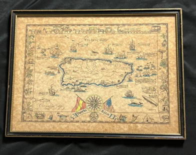
Sold2023Vintage Hand -Colored Pictorial Map of Puerto Rico Circa 1931 by E.B.K. DooleyA vintage hand-colored map of Puerto Rico by E.B.K. Dooley, published c. 1931. This map has a decorative border filled with local plants, wildlife, buildings and transportation. In small scrolls, therSee Sold Price
Sold2018PanAM: Vintage Pictorial World Map, 1957Title/Content of Map: 1957 PanAM Pictorial World Map -- Your Clipper Cargo Market Area Date Printed: 1957 c. Cartographer: PanAm Size: 22 x 34 in. A very interesting world map showing PanAm cargo routSee Sold Price
Sold2021VINTAGE PICTORIAL STORY MAP of ENGLAND w AUTHOR s,VINTAGE PICTORIAL STORY MAP of ENGLAND w AUTHOR s, Artwork by EGBERT JACOBSON VINTAGE PICTORIAL STORY MAP of ENGLAND w AUTHOR s, Artwork by EGBERT JACOBSON Description Vintage Pictorial "THE STORY MAPSee Sold Price
Sold2021Clean Mountains & Rivers, Colton 1890Title: Clean Mountains & Rivers, Colton 1890 Description: Vintage double-page pictorial map of comparative sizes of the world’s mountains and rivers in most likely the last edition of Colton’s GenSee Sold Price
Sold2023Vintage William Shakespeare Stratford-Upon-Avon Pictorial MapVintage William Shakespeare Stratford-Upon-Avon Pictorial Map by Chromoworks LTD. Unframed with matting. Measurements in inches: 28 x 23, image: 24 x 18 Condition:Glued on edges to matting and tear onSee Sold Price
Sold2022Vintage US Military photograph(s) Maps & PICTORIALsDescription: Vintage US Military photograph(s) Maps & PICTORIALs. Approximate measurements: 14 x 10.5 inches. Materials: paper.See Sold Price
2022Vintage US Military photograph(s) Maps & PICTORIALsDescription: Vintage US Military photograph(s) Maps & PICTORIALs. Approximate measurements: 14 x 10.5 inches. Materials: paper.See Sold Price
Sold2023Propaganda Poster South America Map Indian Culture Principal TribesOriginal vintage poster featuring a pictorial map of the Areas of Indian Culture and Principal Tribes in South America marked in the geographical and cultural groups of the Antillean, Chibchan, AmazonSee Sold Price
Sold2023Vintage Pictorial Nantucket Atlas MapVintage Pictorial Nantucket Atlas Map, with numeric and alphabetical directional grid. Overall 12 in. x 17.5 in.See Sold Price
May 16Potter & Potter AuctionsPictorial Map of Hollywood and Vicinity / Hollywood Film Ca...$125(1 bid)
May 16Potter & Potter AuctionsHANDY, R.D. (1879 – 1959). Paul Bunyan’s Pictorial Map of t...$200
May 16Potter & Potter Auctions[NEW YORK CITY – PICTORIAL MAPS]. Group of 3 pictorial maps...$200(1 bid)
May 16Potter & Potter Auctions[PICTORIAL MAPS – TRAVEL]. Three Pictorial Maps. 1940s/50s....$150
May 16Potter & Potter AuctionsSTORM, Mark. Official Texas Brags Map of North America. 194...$200(1 bid)
May 16Potter & Potter AuctionsLINDGREN, Jolly (1895-1952). A Hysterical Map of Yellowstone Park and the Jackson Hole Country$125
May 16Potter & Potter AuctionsLINDGREN, Hjalmer “Jolly” (1895–1952). A Hysterical Map of ...$200
May 16Potter & Potter AuctionsMcCARTY, Lea (1905 – 1960). Sonoma County / Its Highlights ...$100(1 bid)
May 16Potter & Potter AuctionsLANGENECKERT. It’s A Dog’s World. 1968. St. Louis: Ralston ...$100
May 16Potter & Potter AuctionsTUNIS, Edward (1897 – 1973). From Chesapeake Bay / Land of ...$250
May 16Potter & Potter AuctionsBODLEY, Helen (1906 – 1997). A Map of Concord / The Old Mus...$400
May 16Potter & Potter AuctionsBOURNE, Emma (1906 – 1986). America – A Nation of One Peopl...$125(1 bid)
May 16Potter & Potter AuctionsCRAVATH, Glen (1897 – 1964). Py Your Leaf Baron Munchausen ...$80
May 16Potter & Potter AuctionsLINDGREN, Hjalmer “Jolly” (1895–1952). A Hysterical Map of ...$150(1 bid)
May 16Potter & Potter AuctionsBATE, Neel (1916 – 1989). Jimmy and Sally in Mother Goose L...$200


![[NEW YORK CITY – PICTORIAL MAPS]. Group of 3 pictorial maps... (1 of 3)](https://p1.liveauctioneers.com/928/325952/175495562_1_x.jpg?height=282&quality=70&version=1712935174)


![[PICTORIAL MAPS – TRAVEL]. Three Pictorial Maps. 1940s/50s.... (1 of 4)](https://p1.liveauctioneers.com/928/325952/175495561_1_x.jpg?height=282&quality=70&version=1712935174)


