Sold2020Pre 1967 Israel Road MapTitle/Content of Map: Pre 1967 Israel Road Map Date Printed: 1965 Cartographer: Paz Oil Company Material/Medium: paper Size: 27x19.5 inches open, 3.5x8.5 inches folded. 4-fold. approx. 27x19.5 inchesSee Sold Price
Sold2022Assortment of Early Maps, Israel and the Middle EastAssortment of Early Maps, Israel and the Middle East, includes: 1. The Land of Israel: Settlement Map and Road Map, published by Am Oved, 1945, 2. Map of the middle east published by John Bartholomew@See Sold Price
Sold2021HEBREW color map ISRAEL 1978-1967, folded twice to 12 xHEBREW color map ISRAEL 1978-1967, folded twice to 12 x 9 approxnote some creases in upper left and right corners Approximate measurements: 24.5 x 18 inches;Materials: paper, ink;Condition: used, goodSee Sold Price
Sold2016Lot of 3 Silver Snuff BoxesLot of 3 silver snuff boxes (800 silver and sterling silver), one made by I.M. FAIN with a relief of the map of Israel (before 1967), and another one has a gilt interior. Varying sizes. Length: 4-7 cmSee Sold Price
Sold2023Sixteen Northern Railroad Timetables and Map - 1911 to 1967 Northern Pacific and Great NorthernA group of sixteen northern railroad timetables and a map spanning 1911 to 1967. Five Northern Pacific tables dated 1915, 1959, 1962, and 1967. A Great Northern Railway foldout route map and ten tableSee Sold Price
Sold2017Phelps: Antique Pre-Civil War Map of United States 1848Patriotic Antique Pre-Civil War US Map; "Phelps's National Map of the United States, A Travellers Guide. Embracing the principal Rail Roads, Canals, Steam Boat & Stage Routes, Throughout the Union.".See Sold Price
Sold2022Impressive 1st ed. map of Palestine from J. H. Colton, 1855Detailed map of the Holy Land, colored by tribes and showing scripture names, classical names, modern names, roads, rivers, towns, villages, mountains, etc. Includes the modern-day nations of Israel,See Sold Price
Sold2018Meyer: Tennessee, 1849/ Nashville & Knoxville InsetsThe beautifully detailed and colored map of pre-Civil War Tennessee, from Meyer's Auswanderungs-Atlas (Emigrant's Atlas) of North America. Includes a key to canals, railroads, and main roads; steamshiSee Sold Price
Sold2024Keith Haring Artwork Signed on a Shell Oil New York Road Map 18 in. x 24 in.Keith Haring Artwork Signed on a Shell Oil New York Road Map 18 in. x 24 in. size: 18 x 42 open - rippingSee Sold Price
Sold20181967 Israel Gold, The Victory Coin1967 Israel Gold, The Victory Coin, proof, 17.15 dwts., .916 gold.See Sold Price
Sold2022HUSKY GASOLINE SERVICE STATION MAP DISPLAY W/ HUSKY ROAD MAPS.SST. An excellent and complete example of this Circa 1950's Service Station Road Map Display from Husky showing a Tin Husky Sign at the face and complete with Maps. CONDITION: Display is in overall exSee Sold Price
Sold2022New road map of the city of Paris 1839 Rosselin editeur engravingNouveau plan routier de la ville de Paris, Guide exacte de cette capitale : en 12 arrondissemens avec leurs mairies et en 48 quartiers, 1839V. ROSSELIN (19th century), print editor, Paris, EstablishedSee Sold Price
Sold2022British road maps.- Ogilby (John) The Roads fromNO RESERVE British road maps.- Ogilby (John) The Roads from Chelmsford in Essex to St. Edmonds-Bury in Suffolk & Saffron-Walden in Essex, strip road map, engraving with hand-colouring, on thin laid paSee Sold Price
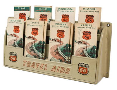
Sold2023Vintage Phillips 66 Road Map Embossed Display RackVintage Phillips 66 embossed plastic road map display rack full with original 1930s Phillips 66 maps. Rack has discoloration, some expected chips/ cracks, and wear from use and age. Displays well withSee Sold Price
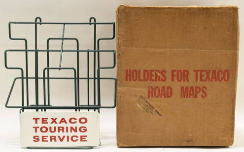
Sold2021Vintage NOS Texaco Road Map Metal Display RackVintage new old stock Texaco road map metal display rack in original box. Nice condition with light wear from age and storage. Display rack measures approximately 10-1/2" tall by 9" across.See Sold Price
Sold2020Road map of Southern California 1918Heading: (California) Author: Title: Automobile Road Map of Los Angeles, Orange, Riverside and San Bernardino Counties Place Published: Los Angeles Publisher:Security Trust & Savings Bank Date PSee Sold Price
Sold2018Auto road map of greater Los Angeles, 1916Heading: (California - Southern) Author: Parker, O.K. Title: Automobile Road Map of Los Angeles, Orange, Riverside and San Bernardino Counties Place Published: Los Angeles Publisher:Security Trust & SSee Sold Price
Sold20221895 Hudson River NY - Harper & Bros Bicycle Road Map1895 Harper & Brothers advertising bicycle map. Route travels along the Hudson River, from below 181st Street to Sleepy Hollow just above Tarrytown New York. Bicycle Road Maps in Harper's Round TableSee Sold Price
Sold2024Two Philadelphia City Road MapsTwo Philadelphia City Road Maps Sidney Hall, "Philadelphia" scale map engraving published Chapman and Hall 1840 14" x 17" along with "Philadelphia" circa 1850 or later map frame size 18 7/8" x 22 1/2"See Sold Price
Sold2021Colton's Road Map of the Counties of Orange andPublication Date: 1896 Title: Colton's Road Map of the Counties of Orange and Rockland Cartographer: G.W. & C.B. Colton & Co. Publisher: G.W. & C.B. Colton & Co. Height: 22.75 Width: 26.25 State of NeSee Sold Price
Sold2022Gulf Tourgide Service road map display with maps & clipboard9" x 18" x 5"d Gulf road map display with maps & Gulf clipboard showing normal wear. *PLEASE NOTE, THERE IS ONLY ONE WAY TO PAY FOR ONLINE ITEMS IN THIS AUCTION WHICH IS THROUGH LIVE AUCTIONEERS. THISSee Sold Price
Sold2021Road map from Mono Lake to Reno 1938Heading: (California & Nevada) Author: Title: Mono Lake to Reno Place Published: San Francisco Publisher:California State Automobile Association Date Published: [c.1938] Description: <See Sold Price
Sold2020MOBIL GASOLINE SERVICE STATION TIN ROAD MAPS DISPLAY W/SST. A very nice example of this Tin Service Station Road Map Display from Mobil Gasoline. Tin is in very good condition, showing only minimal age wear and minor areas of paint loss in the corners. ThSee Sold Price
2 days LeftAlbion AuctionsPaterson & Mogg C1830 British Road Map. Cumberland, Westmorland & Lancashire$5(1 bid)
2 days LeftAlbion AuctionsPaterson & Mogg C1830 British Road Map. New Shorehamd to Chichester to Fareham$5(1 bid)
2 days LeftAlbion AuctionsPaterson & Mogg C1830 British Road Map. Banks of the River Wye. Chepstow etc$5(1 bid)
2 days LeftNi-Cola Classics - Automobilia Auction & Classic Car SalesAutomobilia Road map 'Inverno-Primavera 1937-XV'€50
2 days LeftAlbion AuctionsPaterson & Mogg C1830 British Road Map. Isle of Thanet and Adjacent Country$5(1 bid)
2 days LeftAlbion AuctionsPaterson & Mogg C1830 British Road Map. Rye to Eastbourne to New Shoreham$5


![Road map from Mono Lake to Reno 1938: Heading: (California & Nevada) Author: Title: Mono Lake to Reno Place Published: San Francisco Publisher:California State Automobile Association Date Published: [c.1938] Description: <](https://p1.liveauctioneers.com/642/218849/112379266_1_x.jpg?height=310&quality=70&version=1631923877)


