Sold20211903 Medieval Towns Moscow Paris France Seville Spain1903 Medieval Towns Moscow Paris France Seville Spain Perugia MAPS 4v Hutton William Holden Hutton’s “Medieval Towns” is an early 20th-century set of histories on iconic ancient towns including:See Sold Price
Sold2017America, Rare Early Map of the Americas"America", Rare Early Map of the Americas by Jodocus Hondius (Flemish/Dutch, 1563-1612) for a French edition of Mercator's Atlas, North and South America, hand-colored copper engraved map, published ASee Sold Price
Sold2020Antigua labeled Antego. RARE early map.Title: Antigua labeled Antego. RARE early map. Description: c1732/1736 from the Atlas Minor by Herman Moll, London. VERY IMPORTANT early map of the island. Showing all the settlements and plantations.See Sold Price
Sold2024Map to Acquaint You with the Great Mission Bay Project. 194...Map to Acquaint You with the Great Mission Bay Project. 1948. San Diego: Baker Realty Co. Rare early map of Mission bay with many unrealized concepts including the Trap and Skeet Shooting area, 18 holSee Sold Price
Sold2023Rare Early 1900's Map of Porto Rico ( Puerto Rico )Rare early 1900's ( copyright of 1908 ) Map of Porto Rico, including Port San Juan, Islands West of Porto Rico, Mayaguez Bay & Port Ponce from Rand, McNally & Co. 8 3/4" X 12". ** fold through the cenSee Sold Price
Sold2023Japanese Map of Ancient China, Apparently 12th - 16th CenturyAn exceptional and rare early Japanese map, hand painted, depicting China from the Zhou or Qin Dynasty. The map depicts the Chinese Nine Zhou, or provinces, utilizing nomenclature used in Japan circaSee Sold Price
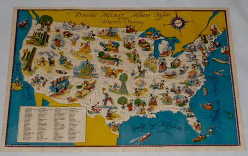
Sold2022Walt Disney Dixon's Mickey Mouse Map of United StatesEarly Disneyana collectible map. Copyright Walt Disney Enterprises 1935. Rare early pictorial map of the United States , richly illustrated with Disney character vignettes in each of the 48 states, MiSee Sold Price
Sold2017Antique Important Map of Texas, 1843Title/Content of Map: Texas. Rare and important early Map. Date Printed: 1843 Cartographer: based on the work of H.C. Tanner Material/Medium: Paper Size: 17" x 14" Hand colored engraved Map. From theSee Sold Price
Sold2023Japanese Map of Feudal Castles Apparently Circa 1550A rare and early Japanese map, depicting the feudal castles of Owari province, including Kiyosu Castle, occupied by Shiba Yoshimune as governor of Owari and head of the Shiba Clan. Apparently of the pSee Sold Price
Sold2023Rare map of Upper Territories by Mathew Carey, 1814Early and rare map of the old Northwest Territory. In this map the area of Michigan has yet to be understood. The extents of Saginaw Bay and Green Bay are also more or less guessed at. The map reflectSee Sold Price
Sold2016JOHN MELISH (SCOTLAND/AMERICAN 1771-1822), EARLY ANDJOHN MELISH (SCOTLAND/AMERICAN 1771-1822), EARLY AND RARE MAP OF THE UNITED STATES OF AMERICA, C.1813. ENTERED AS THE ACT DIRECTS AND PUBLISHED BY JOHN MELISH, PHILADELPHIA, JUNE 1813. SIGHT 13 X 17 1See Sold Price
Sold20181824 RARE & Early American Holy BIBLE New York Daniel S1824 RARE & Early American Holy BIBLE New York Daniel Smith Stereotype ed MAP A large, rare early 19th-century family Bible with Daniel Smith’s stereotype edition. This impressive tome features an iSee Sold Price
Sold2021Early Map of Greece and EnvironsEarly and Rare map by Jean Covens and Corneille Mortier of Greece, the Aegean, Asia Minor and the lower Balkans. 19 ½ x 26 inches (approximately)See Sold Price
Sold2015Kingdom of IrelandJohn Speed (1552-1629). Engraved map. London: 1610 (1676). 17 1/4 x 22 inches. A rare, early printing of John Speed’s renowned map of Ireland. The map is decorated with a panel of costume figures deSee Sold Price
Sold2024JOHANN BAPTIST HOMANN 1700'S SCANDINAVIA MAPExtremely Rare Johann Baptist Homann Early 1700's Map of Scandinavia. Complectins Suci Daniae & Nor Vegiae Regna ex Tabula. A detailed J. B. Homann map of Scandinavia. Depicts both Denmark, Norway, SwSee Sold Price
Sold20181718 BIBLE Dutch ENORMOUS Biblia Hasebroeck HUGE MAPS1718 BIBLE Dutch ENORMOUS Biblia Hasebroeck HUGE MAPS Brass BindingAn exceedingly rare, early 18th-century Dutch Bible published by Dordrecht. This Bible features the Old and New Testaments along withSee Sold Price
Sold2019Eastern seaboard of USA. Rare early view.Reserve Reduced! Title/Content of Map: Eastern seaboard of USA. Rare early view. Date: 1598/99. Cartographer: Ruscelli Size: 11x9” Provenance: Venice. Reserve: $800.00 Jasper52 negotiates the lowestSee Sold Price
Sold2017Bradford: Antique Map of Iowa & Wisconsin, 1838Title/Content of Map: Rare and Important early Iowa and Wisconsin Date Printed: 1838/1841 Cartographer: Thomas G. Bradford Material/Medium: Paper Size: 13" x 16 1/2" Hand colored. A General Atlas of tSee Sold Price
Sold2024Ptolemy & Magini, pub. 1620 - Double Hemisphere Map of the WorldThis early map engraving is from Claudius Ptolemaeus (Ptolemy) and Giovanni Antonio Magini's Geografia cio? Descrittione Universale della Terra Partita in due volumni, Nel Primo de' quali si contengonSee Sold Price
Sold2023World: Ptolemy, pub. 1562 - Map of the Ancient WorldThis early map engraving is Joseph Moleti (Giseppi Moleti [Moletius])'s edition of Claudius Ptolemaeus (Ptolemy)'s Geographia. This is the first Moleti Latin edition of the work and was published by VSee Sold Price
Sold2024Ptolemy & Magini, pub. 1620 - Map of the British Isles (England, Scotland, Ireland) / Verso: Map ofThis early map engraving is from Claudius Ptolemaeus (Ptolemy) and Giovanni Antonio Magini's Geografia cio? Descrittione Universale della Terra Partita in due volumni, Nel Primo de' quali si contengonSee Sold Price
Sold2024Ptolemy & Magini, pub. 1620 - Map of India and Surrounding Islands (East Indies)This early map engraving is from Claudius Ptolemaeus (Ptolemy) and Giovanni Antonio Magini's Geografia cio? Descrittione Universale della Terra Partita in due volumni, Nel Primo de' quali si contengonSee Sold Price
Sold2023Ptolemy, pub. 1562 - Map of ItalyThis early map engraving is Joseph Moleti (Giseppi Moleti [Moletius])'s edition of Claudius Ptolemaeus (Ptolemy)'s Geographia. This is the first Moleti Latin edition of the work and was published by VSee Sold Price
Sold2023Ptolemy, pub. 1562 - Map of Sardinia & SicilyThis early map engraving is Joseph Moleti (Giseppi Moleti [Moletius])'s edition of Claudius Ptolemaeus (Ptolemy)'s Geographia. This is the first Moleti Latin edition of the work and was published by VSee Sold Price
21 hrs LeftUniversity ArchivesCosmonautics Day Envelope PSA MINT 9 Boldly Signed By 6 Soviet Cosmonauts! Gagarin, Titov,$300
Jul 14Schilb Antiquarian Rare Books1819 COLUMBUS 1ed America Magellan USA Washington Cortez MAPS Revolutionary War$70(4 bids)
4 days LeftTrillium Antique Prints & Rare BooksKollner, Rare - Baltimore, Maryland (North West View)$200
4 days LeftTrillium Antique Prints & Rare BooksBraun & Hogenberg, pub. 1575 - View of Edinburgh, Scotland$100(1 bid)
4 days LeftTrillium Antique Prints & Rare BooksBraun & Hogenberg, pub. 1575 - View of Jerusalem$100(1 bid)
4 days LeftTrillium Antique Prints & Rare BooksBraun & Hogenberg, pub. 1575 - Views of Spain: Toledo & Valladolid$100
4 days LeftTrillium Antique Prints & Rare BooksDresser & Keulemans's A Monograph of the Meropidae, or Family of the Bee-Eaters - Volume with 34$2,000
4 days LeftTrillium Antique Prints & Rare BooksPrevost - Chart of the South Pacific Ocean with part of New Holland (Australia), New Zealand, and$75
4 days LeftTrillium Antique Prints & Rare BooksBraun & Hogenberg, pub. 1575 - View of the Phlegraean Fields or Campi Flegrei, Italy$100
4 days LeftTrillium Antique Prints & Rare BooksMouton - View of Carmine, Naples, Italy (Napoli da I. Carmine)$200


![World: Ptolemy, pub. 1562 - Map of the Ancient World: This early map engraving is Joseph Moleti (Giseppi Moleti [Moletius])'s edition of Claudius Ptolemaeus (Ptolemy)'s Geographia. This is the first Moleti Latin edition of the work and was published by V](https://p1.liveauctioneers.com/6581/307341/164260812_1_x.jpg?height=310&quality=70&version=1698409008)


![Ptolemy, pub. 1562 - Map of Italy: This early map engraving is Joseph Moleti (Giseppi Moleti [Moletius])'s edition of Claudius Ptolemaeus (Ptolemy)'s Geographia. This is the first Moleti Latin edition of the work and was published by V](https://p1.liveauctioneers.com/6581/306422/163689119_1_x.jpg?height=310&quality=70&version=1697805653)
![Ptolemy, pub. 1562 - Map of Sardinia & Sicily: This early map engraving is Joseph Moleti (Giseppi Moleti [Moletius])'s edition of Claudius Ptolemaeus (Ptolemy)'s Geographia. This is the first Moleti Latin edition of the work and was published by V](https://p1.liveauctioneers.com/6581/306422/163689120_1_x.jpg?height=310&quality=70&version=1697805653)


