Sold2023Thomson, John (Pub) 1825 Map. United States of AmericaCopper Engraved Map Published 1825 by John Thomson, Edinburgh for "The Edinburgh School Atlas" by N. R. Hewitt. Maps Engraved by Hewitt. Original Outline Hand Colour. Rare. Paper Size: 10.5 x 8 inch (See Sold Price
Sold20171848 Smith Pocket Map of United States1848 Smith Pocket Map of United States -- A New Map for Travelers through the United States of America, Showing the Railroads, Canals & Stage Roads Smith & Son 1848 New York 21 x 26.75 in. A relativelSee Sold Price
Sold2024Ohio copy of Mathew Carey’s 1796 GENERAL ATLASCarey, Mathew (publisher). CAREY’S GENERAL ATLAS. Philadelphia: Printed by Mathew Carey, May 1, 1796. FOLIO (14.75 x 9.5 inches), COMPLETE AS PUBLISHED (including a Rare Map of The United States bySee Sold Price
Sold2020FINLEY, ANTHONY. Map of the United States.FINLEY, ANTHONY. Map of the United States. Fine pocket map of the United States engraved by James Hamilton Young. Thin banknote paper, 17x21 inches sheet size, folding into publisher's red roan case wSee Sold Price
Sold2016JOHN MELISH (SCOTLAND/AMERICAN 1771-1822), EARLY ANDJOHN MELISH (SCOTLAND/AMERICAN 1771-1822), EARLY AND RARE MAP OF THE UNITED STATES OF AMERICA, C.1813. ENTERED AS THE ACT DIRECTS AND PUBLISHED BY JOHN MELISH, PHILADELPHIA, JUNE 1813. SIGHT 13 X 17 1See Sold Price
Sold2024Rare Hand-coloured Map - Florida - Louisiana - United States - BellinIts finely engraved, hand-coloring engraved map from the Dutch edition of acques Nicolas Bellin "Histoire General of Travel". Published in Amsterdam, 1770 year. Carte de la Floride de la LouSee Sold Price
Sold2024Glasgow Geography 1825 Antique Map. United States of AmericaCopper Engraved Map Published 1825, Glasgow for "The Glasgow Geography?" by Several Literary Gentleman. Folds as issued. .Paper Size: 11 x 8 inch (28 x 21cm) Good ConditionSee Sold Price
Sold2021Rare c1780s U. S. map showing FrankliniaRare and unusual map of the United States showing early borders of various states. The seller has not been able to locate another copy of this map. The map appears to either be a source for, or copy oSee Sold Price
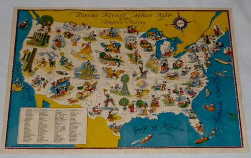
Sold2022Walt Disney Dixon's Mickey Mouse Map of United StatesEarly Disneyana collectible map. Copyright Walt Disney Enterprises 1935. Rare early pictorial map of the United States , richly illustrated with Disney character vignettes in each of the 48 states, MiSee Sold Price
Sold20231865 Colton's RR and Military Map of the US1865 "Colton's Railroad & Military Map of the United States", folding pocket map laid down on board, framed, some toning from oxidation, 32 1/2" x 42"See Sold Price
Sold2017Antique Map of the United States of America c 1825Antique Map of the United States of America c 1825. Antique hand colored map. Some damages. Measures 17.5 x 21 inches.See Sold Price
Sold20241825 Framed United States MapApprx 23 1/2" x 27 1/2". If shipping is needed, get a quote thru UPS Store 5528 before bidding.See Sold Price
Sold2023WWII 1944 United States Army Air Forces AAF Installations RARE Restricted MapWWII 1944 Army Air Forces AAF Installations Main Bases and Sub Bases in the Continental United States. RARE Restricted Map. Approximate size is 32 x 20 inches. Nice condition for its age.See Sold Price
Sold2023Rare 19thc Census Map, U.S. Agricultural ProductionExtremely rare, original 1876 atlas map of the United States Agriculture Production - five agricultural maps (in inset form) of the production of wheat, hay, corn, cotton and tobacco. Each map distingSee Sold Price
Sold20221864 Civil War MAP United States Statistics Commerce1864 Civil War MAP United States Statistics Commerce American Trade Gold Silver The United States Department of Treasury published this Civil War-era report analyzing the commerce of the US GovernmentSee Sold Price
Sold20221872 Vermont Directory MAP United States Constitution1872 Vermont Directory MAP United States Constitution Government Color The Directory, Rules Constitutions and Manual of Parliamentary Practice was a regularly published government periodical from VermSee Sold Price
Sold20211849 President Zachary Taylor on INDIANS Navajo1849 President Zachary Taylor on INDIANS Navajo Seminole Florida Gold Rush MAP United States Congressional reports and messages have long been a popular and highly desirable commodity, especially thosSee Sold Price
Sold20211873 Geography ATLAS MAPS United States Weather Owned1873 Geography ATLAS MAPS United States Weather Owned by Communist Spy ‘An Elementary Treatise on Physical Geography’ is a late 19th-century atlas and geography treatise. Collected by D.M. Warren,See Sold Price
Sold20231894 ALASKA California 18 MAPS United States Geodetic Surveys State Boundaries1894 ALASKA California 18 MAPS United States Geodetic Surveys State Boundaries Throughout the 19th-century, the United States government published countless reports and surveys on natural history of ASee Sold Price
Sold2016A Map of the United States & MexicoHenry Tanner (1786-1858). New York: Tanner, 1850. Hand-colored Pocket Map. 23 x 29 inches visible, 38 x 39 1/2 inches framed.See Sold Price
Sold2022(CIVIL WAR.) P.S. Duval & Son. Military Map of the United States & Territories(CIVIL WAR.) P.S. Duval & Son. Military Map of the United States & Territories Showing the Location of the Military Posts, Arsenals, Navy Yards, & Ports of Entry. Hand-colored lithographed pocket mapSee Sold Price
Sold2015Map of the United States Drawn fromthe Most Approved Surveys 1825, a copper-engraved map on banknote paper folded into thin morocco covers lettered in gilt "U. STATES," a pocket map, map measures 16-3/4 x 20 in., morocco covers measureSee Sold Price
Sold20181835 Pocket map and traveller's guide by MitchellHeading: Author: Mitchell, S. Augustus Title: Mitchell's Compendium of the Internal Improvements of the United States Place Published: Philadelphia Publisher:Mitchell & Hinman Date Published: </See Sold Price
Sold20232 Travel Maps of US: Atwood Pocket Map 1851 & Williams Framed, 18541st item: PHELPS'S NATIONAL MAP OF THE UNITED STATES, TRAVELLERS GUIDE. EMBRACING THE PRINCIPAL RAIL ROADS, CANALS, STEAM BOAT & STAGE ROUTES THROUGHOUT THE UNION, by J. M. Atwood, published by ThayerSee Sold Price
2 hrs LeftChampagne AuctionsBryant, Willem Cullen, dir. - L'Amérique du nord pittoresque. - 1880CA$20
4 days LeftTrillium Antique Prints & Rare BooksCarey, pub. 1796 - Map of the State of New Jersey$75(1 bid)
4 days LeftTrillium Antique Prints & Rare BooksCarey, pub. 1805 - Map of the State of New Hampshire$75
4 days LeftTrillium Antique Prints & Rare BooksKollner, Rare - Niagara Falls, Horseshoe Fall, from the Canada Side$200
Oct 26Sofe Design AuctionsRare Early Variation (USMC) Marine Raider Stiletto Fighting Knife$900(1 bid)
1 day LeftJasper52Large Civil War map of the United States. ETTLING. Illustrated London News 1861$300
Oct 12JM Hobby Supply and Railroad Artifact AuctionsLionel 1958 Railroad Map of the United States$20(1 bid)
Oct 12JM Hobby Supply and Railroad Artifact AuctionsChicago Burlington and Quincy RR 1921 United States Map$20(1 bid)
5 days LeftKCM GalleriesLarge Detailed Original Oil Painting United States Map Julius Lira Salazar 48 x 36 inches$1,800