Sold2023VINTAGE MAP OF NANTUCKET ISLAND & SOUNDDimensions: (Frame) H 40" x W 48" Condition: Not examined out of frame. Map appears clean, colors bright. Frame with a few dings and rubs.See Sold Price
Sold2018Framed & Matted Vintage Map Of The BermudasAntique Map Of The Bermudas, this colored map is professionally framed and matter in a black with gold detailed frame with maroon matting, it is measured at 27.5 x 23 inchesSee Sold Price
Sold2022Vintage Map of Block Island RI 25.5"x20.5"Vintage Map of Block Island RI 25.5"x20.5"See Sold Price
Sold2019Vintage Map of Fiji Islands and Samoa IslandsVintage Map of Fiji Islands and Samoa IslandsSee Sold Price
Sold2021Fine map of New York City and Brooklyn, 1872Title: Fine map of New York City and Brooklyn, 1872 Description: Beautifully centered double-page vintage map of Manhattan Island and Brooklyn, with inset of the Northern Portion of New York City andSee Sold Price
Sold20231685 map of Aegean Sea islands by Alain MalletAuthentic vintage map of the islands of Psara, Sio, Stelari, and Strongiolo in the Aegean Sea by Alain Mallet. Map is from his Description de L’Univers published in 1685, Frankfurt by Johann DaSee Sold Price
Sold2023ESTATE OF SEYMOUR STEIN: "A MAP OF LONG ISLAND" FRAMED VINTAGE MAP 22" X 29 1/2" OVERALLESTATE OF SEYMOUR STEIN: "A MAP OF LONG ISLAND" FRAMED VINTAGE MAP 22" X 29 1/2" OVERALLSee Sold Price
Sold2022Shirley, Mastic Acres, Long Island Maps (2)Shore.Shirley, Mastic Acres, Long Island Maps (2). Vintage 1950s colorful brochure with map, etc., for Shirley, Long Island, promoting development. With separate Mastic Acres map. Town of Brookhaven,See Sold Price
Sold2023Vintage 14K Gold Nantucket Island Map Pendant NecklaceVintage 14K Gold Nantucket Island Map Pendant Necklace, the reverse marked "14K", the chain marked "Italy 14K Aurea". Chain length 14 in. Width of pendant .9 in. Weight 3.7 dwt.See Sold Price
Sold2022Islands Bahamas Vintage Pictorial Map Poster GicleeIslands Bahamas Vintage Pictorial Map Poster Giclee Canvas Print 40x35See Sold Price
Sold2022Six Atlas of New York and Vicinity, hand colored engraved maps including Sommers, Patterson,Six Atlas of New York and Vicinity, hand colored engraved maps including Sommers, Patterson, Wakefield, Ossining, City Island, and North Salem, 16 3/4" x 13 3/4". Provenance: Originally from Credit SuSee Sold Price
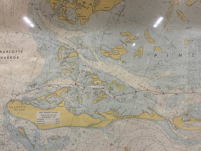
Sold2024Vintage Framed Pine Island & Lacoste Island MapVintage full color paper map, marked on top Pine island, Charlotte harbor and Lacosta island. Showing waterways and directions. Framed in a wooden frame. Approx 14 x 18 inches window measures 11.5 x 1See Sold Price
Sold2018CARIBBEAN CENTRAL AMERICA. Industry & Comms; PanamaTITLE/CONTENT OF MAP: 'West Indies and Central America : Industries and Communications; Inset maps of Panama Canal; Bermudas; Kingston; Havana; Windward Islands' This map is folding hence the centrefoSee Sold Price
Sold2018Harmsworth: Antique Map of the Caribbean, 1907TITLE/CONTENT OF MAP: 'West Indies and Central America : Industries and Communications; Inset maps of Panama Canal; Bermudas; Kingston; Havana; Windward Islands' DATE PRINTED: 1907 IMAGE SIZE: ApproxSee Sold Price
Sold2023Vintage Mid Century Aerial Photograph Collage Map of Nantucket IslandVintage Mid Century Aerial Photograph Collage Map of Nantucket Island, circa 1951, compiled by the U.S. Department of Agriculture, Production and Marketing Administration, constructed by overlaying aeSee Sold Price
Sold2021Two Framed Vintage Maps of NantucketOne is a map of the island, the other a street map with vignettes of historical landmarks. Both published by Mitchell's Book Corner in 1973, both 17H inches x 22W inchesSee Sold Price
Sold2022Long Island Pictorial MapA Map of Long Island. Courtland Smith. Billboard Barn: 1933. Vintage map. Scattered creases. Overall 22 1/2" x 30".See Sold Price
Sold2022[BERMUDA] Pair of vintage map posters. Including:[BERMUDA] Pair of vintage map posters. Including: PETRUCCELLI, A. Bermuda. 1966. 24 1/8 x 39 5/8”. Linen backed. Minor repaired tears in margins. – The Bermuda Islands. USA: Bermuda TradeSee Sold Price
Sold2023S AMERICA. Bolivia-Paraguay Gran Chaco border dispute. Chile Argentina 1920 mapTitle: S AMERICA. Bolivia-Paraguay Gran Chaco border dispute. Chile Argentina 1920 map Description: South America ( Section III ); Inset Falkland Islands' by Harmsworth (1920). Vintage colour map, 34.See Sold Price
Sold2017White: Vintage Pictorial Map of Oahu, 1930Map: 1930 White Map of Oahu -- The Island of Oahu Cartographer: R White Year / Place: 1930 Map Dimensions: 11.3 x 14.6 in. Condition: Very Good. Nice colored impression. Very little toning. A very attSee Sold Price
Sold2023HILTON HEAD ISLAND IN CIVIL WAR Union NavyDEPARTMENT OF THE SOUTH : HILTON HEAD ISLAND - SC. by Robert Carse 1961 First Edition, many vintage illustrations, map endpapers, 156pp, Index. Lincoln established the Union's Depertment Of The SouthSee Sold Price
Sold2023COLLECTION VINTAGE PENNANTS / MAPSCollection of pennants and maps including; 1964-5 World's Fair, Six Flags-Georgia, Mt. Vernon, Staten Island Zoo, Hershey Pa, Niagara Falls, West Point, etcSee Sold Price
5 days LeftJasper52Cuba, the Bahamas & Bermuda "or Summer Islands". Turks & Caicos THOMSON 1830 map$170
Featured5 days LeftJasper52The Bahamas, Cuba & Bermuda "or Summer Islands". THOMSON 1817 old antique map$190
Jul 06Rafael Osona AuctionsVintage John H. Martin Hand Colored Map of Nantucket "Geological Base"$300
Crawford Family Auctions LLC6 pcs Vintage Paper Maps. Vancouver Island, British Columbia. Upper Elk Creek Sheet. See pics.$10
5 days LeftJasper52BRITISH/US VIRGIN ISLANDS Tortola Virgin Gorda St Croix St Thomas/John 1923 map$55
5 days LeftJasper52BRITISH/US VIRGIN ISLANDS Tortola Virgin Gorda St Croix St Thomas/John 1927 map$55
5 days LeftJasper52BRITISH/US VIRGIN ISLANDS Tortola Virgin Gorda St Croix St Thomas/John 1935 map$60
Featured5 days LeftJasper52British West Indies. Virgin Leeward Windward Islands. Bermuda. SWANSTON 1860 map$120
5 days LeftJasper52Central America Caribbean Gulf of Mexico chart Ports lighthouses LARGE 1918 map$45


![[BERMUDA] Pair of vintage map posters. Including:: [BERMUDA] Pair of vintage map posters. Including: PETRUCCELLI, A. Bermuda. 1966. 24 1/8 x 39 5/8”. Linen backed. Minor repaired tears in margins. – The Bermuda Islands. USA: Bermuda Trade](https://p1.liveauctioneers.com/928/230548/119288256_1_x.jpg?height=310&quality=70&version=1639776029)


