
No upcoming results for "joseph-brice"
But we've sold 10000 before. Follow this search to get notified as soon as more arrive.


You May Also Like
![[Science & Technology]. Diderot, Denis (1713-1784) and Jean le Rond D' Alembert (1717-1783),: [Science & Technology]. Diderot, Denis (1713-1784) and Jean le Rond D' Alembert (1717-1783), editors. EncyclopÈdie, ou dictionnaire raisonnÈ des sciences, des arts et des mÈtiers...Nouv](https://p1.liveauctioneers.com/197/423392/235638032_1_x.jpg?height=310&quality=70&version=1783023069)
$600
![[MAPS] 1790s Yazoo Land Scandal "Tennessee Company" Hand Drawn Map: BEAUTIFUL HAND-DRAWN MAP SHOWING "WASHINGTON DISTRICT" (THE STATE OF FRANKLIN) AND THE "TENNESSEE COMPANY" FORMED BY THE SECRET "COMBINED SOCIETY" RESPONSIBLE FOR THE YAZ](https://p1.liveauctioneers.com/7226/422185/235035214_1_x.jpg?height=310&quality=70&version=1781916990)
$100
![[MAPS] 1820 Harmon's "Map of the Interior of America": A Map of the Interior of North America. Engraved map. Boston: Annin & Smith, [1820]. 1 page, 18 15/16 x 7 3/4 in. FROM Daniel W. Harmon. A Journal of Voyages and Travels in the I](https://p1.liveauctioneers.com/7226/422185/235035227_1_x.jpg?height=310&quality=70&version=1781916990)
![[Civil War]. Military Map of the United States and Territories Showing the Location of Military: [Civil War]. Military Map of the United States and Territories Showing the Location of Military Posts, Arsenals, Navy Yards, and Points of Entry. Philadelphia: P.S. Duval & Son, 1861. 12mo. Engraved f](https://p1.liveauctioneers.com/197/423392/235637830_1_x.jpg?height=310&quality=70&version=1783023069)
$200
![[MAPS AND ATLASES]. MITCHELL, S. Augustus (1792-1868). Mitchell's School Atlas. Philadelphia:: [MAPS AND ATLASES]. MITCHELL, S. Augustus (1792-1868). Mitchell's School Atlas. Philadelphia: Thomas, Cowperthwait & Company, 1839 [-1840]. 4to. Illustrated with 10 full-page and 4 double-page hand-co](https://p1.liveauctioneers.com/928/421136/234320838_1_x.jpg?height=310&quality=70&version=1781294369)
$150

$100

CA$50


Similar Items on
Explore similar finds from our sister marketplace, Chairish

10000 past auction results for "joseph-brice"
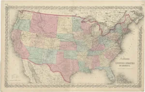
Browse a record of outcomes from past auctions, including sale prices and unsold items.![[MAPS & ATLASES]. COLTON, Joseph Hutchins. Colton's Map of the United States of America, the: [MAPS & ATLASES]. COLTON, Joseph Hutchins (1800-1893). Colton's Map of the United States of America, the British Provinces, Mexico and the West Indies. Showing the Country from the Atlantic to the](https://p1.liveauctioneers.com/197/305583/163286506_1_x.jpg?height=280&quality=70&sharpen=true&version=1697143109&width=280)
Freeman'sChicago, IL

Ahlers & Ogletree Auction GalleryAtlanta, GA

Neal Auction CompanyNew Orleans, LA

Neal Auction CompanyNew Orleans, LA

Artemis Fine ArtsLouisville, CO

The Benefit Shop Foundation Inc.Mount Kisco, NY

Langston Auction GalleryWilson, NC

Jasper52New York, NY

Westside Traders EmporiumRochester, NY

Jasper52New York, NY

Old Kinderhook Auction CompanyValatie, NY

Cordier AuctionsHarrisburg, PA

Frasher's Doll AuctionOak Grove, MO

Frasher's Doll AuctionOak Grove, MO

Donny Malone AuctionsSaugerties, NY

Gallery AuctionsHouston, TX

Clark's Auction CompanyScotts Valley, CA

Schilb Antiquarian Rare BooksColumbia, MO

Riverfront AuctionsCincinnati, OH

Brandywine Valley AuctionsChadds Ford, PA

Cutler Bay AuctionsCutler Bay, FL

Brandywine Valley AuctionsChadds Ford, PA

Cutler Bay AuctionsCutler Bay, FL

Hyde Park Country AuctionsPoughkeepsie, NY
TOP