
No upcoming results for "robert-stoller"
But we've sold 10000 before. Follow this search to get notified as soon as more arrive.


You May Also Like
![[MAPS] 1790s Yazoo Land Scandal "Tennessee Company" Hand Drawn Map: BEAUTIFUL HAND-DRAWN MAP SHOWING "WASHINGTON DISTRICT" (THE STATE OF FRANKLIN) AND THE "TENNESSEE COMPANY" FORMED BY THE SECRET "COMBINED SOCIETY" RESPONSIBLE FOR THE YAZ](https://p1.liveauctioneers.com/7226/422185/235035214_1_x.jpg?height=310&quality=70&version=1781916990)
$100
![[Civil War]. Military Map of the United States and Territories Showing the Location of Military: [Civil War]. Military Map of the United States and Territories Showing the Location of Military Posts, Arsenals, Navy Yards, and Points of Entry. Philadelphia: P.S. Duval & Son, 1861. 12mo. Engraved f](https://p1.liveauctioneers.com/197/423392/235637830_1_x.jpg?height=310&quality=70&version=1783023069)
$200
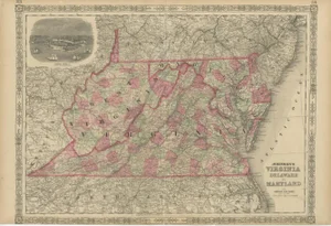
![[MAPS AND ATLASES]. MITCHELL, S. Augustus (1792-1868). Mitchell's School Atlas. Philadelphia:: [MAPS AND ATLASES]. MITCHELL, S. Augustus (1792-1868). Mitchell's School Atlas. Philadelphia: Thomas, Cowperthwait & Company, 1839 [-1840]. 4to. Illustrated with 10 full-page and 4 double-page hand-co](https://p1.liveauctioneers.com/928/421136/234320838_1_x.jpg?height=310&quality=70&version=1781294369)
$150

$150

CA$50
![[WESTERN EXPANSION, RAILROADS] 1867 General Land Office Map: Joseph Gorlinski (1825-1900). Map of the United States and Territories showing the extent of Public Surveys and other Details. [Washington, D.C.: General Land Office; Bowen & Co, lithogr](https://p1.liveauctioneers.com/7226/422185/235035403_1_x.jpg?height=310&quality=70&version=1781916990)
$150


Similar Items on
Explore similar finds from our sister marketplace, Chairish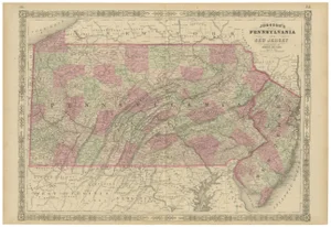
10000 past auction results for "robert-stoller"
Browse a record of outcomes from past auctions, including sale prices and unsold items.
A.H. Wilkens Auctions & AppraisalsToronto, Ontario

The Benefit Shop Foundation Inc.Mount Kisco, NY

The Benefit Shop Foundation Inc.Mount Kisco, NY

The Benefit Shop Foundation Inc.Mount Kisco, NY

Joseph Robert JewelersGuilford, CT

Dallas Auction GalleryDallas, TX

Lunds Auctioneers & Appraisers Ltd.Victoria, BC

Lunds Auctioneers & Appraisers Ltd.Victoria, BC

Lunds Auctioneers & Appraisers Ltd.Victoria, BC

Esquis AuctionsWheeling, IL

Esquis AuctionsWheeling, IL

Esquis AuctionsWheeling, IL

Emanon Auctions and Estate SalesKeyport, NJ

Emanon Auctions and Estate SalesKeyport, NJ

Esquis AuctionsWheeling, IL

Esquis AuctionsWheeling, IL

Jasper52New York, NY

Jasper52New York, NY

Jasper52New York, NY

Jasper52New York, NY

Jasper52New York, NY

Jasper52New York, NY

Jasper52New York, NY
![Robert Tenorio (b. 1950, Kewa/Santo Domingo Pueblo): Robert Tenorio (b. 1950, Kewa/Santo Domingo Pueblo) A polychrome pottery jar, late 20th/early 21st century Incised to underside: [stars] Robert Tenorio / Santo Domingo Pueblo / NM The three-color jar](https://p1.liveauctioneers.com/255/384307/212681148_1_x.jpg?height=280&quality=70&sharpen=true&version=1754448655&width=280)
John Moran Auctioneers, Inc.Monrovia, CA
TOP