Antiquarian Pictorial Maps & City Views 2020-09-08 Auction - 171 Price Results - Jasper52 in NY - Page 6
LiveAuctioneers Logo

1588 Braun and Hogenberg View of Stade, Germany --1598 Muster View of Cairo -- [Die Statt Alfair]1838 Map of Amsterdam
Done
New York, NY, United States
Auction Details

Antiquarian Pictorial Maps & City Views

Jasper52

Jasper52

badge TOP RATED
Explore both land and sea with this array of unique pictorial maps and city views. With this focused yet diverse auction, discover a map of London around St. Paul's Cathedral from 1720, or relive history with a rare map of eastern Germany from 1596. Not only will these maps serve as decorative pieces, but they also will reveal innumerable ways to view our world.
Auction Curator:
Steve Kovacs
Steve Kovacs
Maps Expert
Lot Number: Lowest
24
1888 Map of Jerusalem: Author: CramTitle: 1888 Map of JerusalemMedium: Ink on PaperDimensions: 14.5"X11" Map of Jerusalem dated 1888. Part of Watson Universal Atlas published Chicago. Map is based on an ordenance survey.
0134: 1888 Map of JerusalemEst. $30-$40Lot Passed
1887 Map of Calcutta: Author: CramTitle: 1887 Map of CalcuttaMedium: Ink on PaperDimensions: 14.5"X11.5" Map of Calcutta dated 1887. Engraved and published by George Cram in Chicago. Part of Standard World Atlas. Very
0135: 1887 Map of CalcuttaEst. $30-$40Lot Passed
1888 Map of Constantinopole: Author: CramTitle: 1888 Map of ConstantinopoleMedium: Ink on PaperDimensions: 13.5"X10.5" Map of Constantinopole-present day Istanbul dated 1888. Engraved an published by George Cram in Chicago. Key
0137: 1888 Map of ConstantinopoleEst. $30-$40Lot Passed
Sold
Geographia Pictorial Plan of London: Title: Geographia Pictorial Plan of LondonCartographer: "Geographia" Ltd.Publisher: "Geographia" Ltd.Size: 18.3Height - 28Width Birdseye view plan of interest for the insets of the clubs and
0139: Geographia Pictorial Plan of LondonEst. $40-$50
See Sold Price
Sold
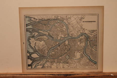
1890 Map of St. Petersburg: Author: CramTitle: 1890 Map of St. PetersburgMedium: Ink on PaperDimensions: 13.5"X11" Map of St. Petersburg dated 189o. Engraved and published by George Cram in Chicago. Very detailed. Key lower
0141: 1890 Map of St. PetersburgEst. $30-$40
See Sold Price
1832 Map of Pompeii: Author: NicholsonTitle: 1832 Map of PompeiiMedium: Ink on PaperDimensions: 16"X14" Map of Pompeii dated 1832. Drawn by W.E. Clarke and engraved by T.E.Nicholson. Published by Baldwin and Cradock in
0142: 1832 Map of PompeiiEst. $50-$60Lot Passed
Sultzburg [City Plan and View]: Title: Sultzburg [City Plan and View]Cartographer: BRAUN & HOGENBERGPublisher: BRAUN & HOGENBERGSize: 5.5Height - 7Width Town plan and view on two sheets. Light browning in upper left corner.
0143: Sultzburg [City Plan and View]Est. $150-$200Lot Passed
Sold
1889 Map of Toronto: Author: CramTitle: 1889 Map of TorontoMedium: Ink on PaperDimensions: 14.5"X11.5" Map of Toronto dated 1889. Engraved and published by George Cram in Chicago. Very detailed map of the city. Map key
0144: 1889 Map of TorontoEst. $30-$40
See Sold Price
Sold
1838 Map of Amsterdam: Author: WalkerTitle: 1838 Map of AmsterdamMedium: Ink on PaperDimensions: 16"X14" Map of the city of Amsterdam dated 1836. Drawn by W.B. Clarke and engraved by H.R. Davies. Published by Baldwin and
0145: 1838 Map of AmsterdamEst. $50-$60
See Sold Price
1886 Map of Birmingham: Author: CramTitle: 1886 Map of BirminghamMedium: Ink on PaperDimensions: 14.5"X11.5" Map of Birmingham dated 1886. Engraved and published by Watson in Chicago. Part of his World Atlas. Very
0148: 1886 Map of BirminghamEst. $30-$40Lot Passed
Country Around Sandhurst: Title: Country Around SandhurstCartographer: Ordnance SurveyPublisher: Ordnance SurveySize: 26Height - 37.7Width published by Col. A. C. Cooke. Printed from an electrotype taken in 1888. (Railroads
0150: Country Around SandhurstEst. $250-$300Lot Passed
New York Bay and Harbor: Title: New York Bay and HarborCartographer: O. H. TITTMANPublisher: U.S. COAST AND GEODETIC SURVEYSize: 33Height - 26.4Width Rare captain's chart on heavy chart paper rolled, as usual for shipboard
0157: New York Bay and HarborEst. $900-$1,100Lot Passed
1925 Map of Florence: Author: PineiderTitle: 1925 Map of FlorenceMedium: Ink on PaperDimensions: 28.5"X22.5" Map of Florence dated 1925. Published by Francesco Pineider. Wall size map. Complete with historical,
0158: 1925 Map of FlorenceEst. $250-$300Lot Passed
View:
24
TOP