Maps of the 1800s 2021-03-17 Auction - 98 Price Results - Jasper52 in NY
LiveAuctioneers Logo

1858 World Map1892 Civil War Map1892 Civil War Map
Done
New York, NY, United States
Auction Details

Maps of the 1800s

Jasper52

Jasper52

badge TOP RATED
In this auction you can discover collector's maps that date back to the 1800s! Presented by a third generation art, engravings and map dealer, this collection covers a wide array of maps from the 1800s. Explore this catalog to discover Civil War Maps from 1892 and much more! All items are carefully vetted and acquired in our overseas buying trips.
Lot Number: Lowest
24
Sold
1882 Map of the Pacific Ocean: Title: 1882 Map of the Pacific OceanMedium: Ink on PaperDimensions: 21"X15"Description: Map of the Pacific Ocean dated 1882. Part of the Comprehensive Atlas & Geography of the World. Engraved by
0001: 1882 Map of the Pacific OceanEst. $40-$50
See Sold Price
1882 Map of New Zealand: Title: 1882 Map of New ZealandMedium: Ink on PaperDimensions: 15"X21"Description: Map of New Zealand dated 1882. Part of the Comprehensive Atlas & Geography of the World. Engraved by J. Bartholomew
0002: 1882 Map of New ZealandEst. $40-$50Lot Passed
Sold
1882 Map of the US West Coast: Title: 1882 Map of the US West CoastMedium: Ink on PaperDimensions: 21"X15"Description: Map of US West Coast dated 1882. Part of the Comprehensive Atlas & Geography of the World. Engraved by J. W.
0003: 1882 Map of the US West CoastEst. $40-$50
See Sold Price
Sold
1882 Map of the US East Coast: Title: 1882 Map of the US East CoastMedium: Ink on PaperDimensions: 15"X21"Description: Map of US East Coast dated 1882. Part of the Comprehensive Atlas & Geography of the World. Engraved by J. W.
0004: 1882 Map of the US East CoastEst. $40-$50
See Sold Price
1882 Map of North America: Title: 1882 Map of North AmericaMedium: Ink on PaperDimensions: 15"X21"Description: Map of North America dated 1882. Part of the Comprehensive Atlas & Geography of the World. Engraved by J. W. Lowry
0005: 1882 Map of North AmericaEst. $50-$60Lot Passed
1882 Map of South Africa: Title: 1882 Map of South AfricaMedium: Ink on PaperDimensions: 21"X15"Description: Map of South Africa dated 1882. Part of the Comprehensive Atlas & Geography of the World. Engraved by Edwin Weller
0006: 1882 Map of South AfricaEst. $40-$50Lot Passed
1882 Map of Western Africa: Title: 1882 Map of Western AfricaMedium: Ink on PaperDimensions: 21"X15"Description: Map of Western Africa dated 1882. Part of the Comprehensive Atlas & Geography of the World. Engraved by Edwin
0007: 1882 Map of Western AfricaEst. $40-$50Lot Passed
1882 Map of Northern Africa: Title: 1882 Map of Northern AfricaMedium: Ink on PaperDimensions: 21"X15"Description: Map of Northern Africa dated 1882. Captures modern day Marocco, Algeria and Tunisia. Part of the Comprehensive
0008: 1882 Map of Northern AfricaEst. $40-$50Lot Passed
Sold
1882 Map of East Indies: Title: 1882 Map of East IndiesMedium: Ink on PaperDimensions: 21"X15"Description: Map of East Indies dated 1882. Captures modern day Philippines, Thailand and Indonesia. Part of the Comprehensive
0009: 1882 Map of East IndiesEst. $40-$50
See Sold Price
1882 Map of the Caspian Sea: Title: 1882 Map of the Caspian SeaMedium: Ink on PaperDimensions: 21"X15"Description: Map of the Caspian Sea dated 1882. Captures modern day Turkmenistan, Afghanistan, Persia and part of Russia. Part
0010: 1882 Map of the Caspian SeaEst. $40-$50Lot Passed
1882 Map of Asia: Title: 1882 Map of AsiaMedium: Ink on PaperDimensions: 21"X15"Description: Map of Asia dated 1882. Captures the Northern part of the continent including Siberia. Part of the Comprehensive Atlas &
0011: 1882 Map of AsiaEst. $40-$50Lot Passed
Sold
1882 Map of Armenia: Title: 1882 Map of ArmeniaMedium: Ink on PaperDimensions: 21"X15"Description: Map of Armenia dated 1882. Part of the Comprehensive Atlas & Geography of the World. Engraved by Edwin Weller under the
0012: 1882 Map of ArmeniaEst. $50-$60
See Sold Price
1882 Map of Syria: Title: 1882 Map of SyriaMedium: Ink on PaperDimensions: 21"X15"Description: Map of Syria dated 1882. Includes Palestine. Part of the Comprehensive Atlas & Geography of the World. Engraved by William
0013: 1882 Map of SyriaEst. $50-$60Lot Passed
1882 Map of Turkey: Title: 1882 Map of TurkeyMedium: Ink on PaperDimensions: 21"X15"Description: Map Turkey dated 1882. Captures the Asian side. Part of the Comprehensive Atlas & Geography of the World. Engraved by
0014: 1882 Map of TurkeyEst. $50-$60Lot Passed
1882 Map of Ceylon: Title: 1882 Map of CeylonMedium: Ink on PaperDimensions: 10.5"X15"Description: Map of Ceylon-modern day Sri Lanka dated 1882. Part of the Comprehensive Atlas & Geography of the World. Engraved by
0016: 1882 Map of CeylonEst. $30-$40Lot Passed
1882 Map of Burma and Siam: Title: 1882 Map of Burma and SiamMedium: Ink on PaperDimensions: 10.5"X15"Description: Map of Burma and Siam-modern day Thailand dated 1882. Part of the Comprehensive Atlas & Geography of the World.
0017: 1882 Map of Burma and SiamEst. $30-$40Lot Passed
Sold
1892 Map of Euro-Asia: Title: 1892 Map of Euro-AsiaMedium: Ink on PaperDimensions: 19"X13.5"Description: Map of Europe and Asia dated 1892. Part of Bacon's Commercial and Library Atlas of the World. Published by G.W. Bacon
0018: 1892 Map of Euro-AsiaEst. $40-$50
See Sold Price
Sold
1892 World Hemispherical Map: Title: 1892 World Hemispherical MapMedium: Ink on PaperDimensions: 19"X13.5"Description: World Hemispherical map dated 1892. Part of Bacon's Commercial and Library Atlas of the World. Published by
0019: 1892 World Hemispherical MapEst. $50-$60
See Sold Price
1828 Map of Antique Africa: Title: 1828 Map of Antique AfricaMedium: Ink on PaperDimensions: 10.5"X8.5"Description: Map of Ancient Africa dated 1828. Part of Butler's Antique World Atlas. Drawn and engraved by Sydney Hall.
0020: 1828 Map of Antique AfricaEst. $30-$40Lot Passed
Sold
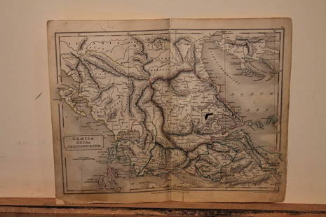
1828 Map of Ancient Greece: Title: 1828 Map of Ancient GreeceMedium: Ink on PaperDimensions: 10"X8.5"Description: Map of Ancient Greece dated 1828. Part of Butler's Antique World Atlas. Drawn and engraved by Sydney Hall.
0021: 1828 Map of Ancient GreeceEst. $30-$40
See Sold Price
Sold
1828 Map of Ancient Greek Isles: Title: 1828 Map of Ancient Greek IslesMedium: Ink on PaperDimensions: 8.5"X10.5"Description: Map of Ancient Greek Isles dated 1828. Part of Butler's Antique World Atlas. Drawn and engraved by Sydney
0022: 1828 Map of Ancient Greek IslesEst. $30-$40
See Sold Price
1892 Civil War Map: Title: 1892 Civil War MapMedium: Ink on PaperDimensions: 29.5"X18.5"Description: Civil War map dated 1892. Published under the direction of the Hon. Stephen B. Elkins Secretary of War. These maps
0023: 1892 Civil War MapEst. $100-$200Lot Passed
1892 Civil War Map: Title: 1892 Civil War MapMedium: Ink on PaperDimensions: 29.5"X18.5"Description: Civil War map dated 1892. Published under the direction of the Hon. Stephen B. Elkins Secretary of War. These maps
0024: 1892 Civil War MapEst. $100-$120Lot Passed
View:
24
TOP