Antique Maps of the World 2021-10-13 Auction - 94 Price Results - Jasper52 in NY
LiveAuctioneers Logo

1785 Martinique Map1892 Tennessee Civil War Map1785 Antilles Map
Done
New York, NY, United States
Auction Details

Antique Maps of the World

Jasper52

Jasper52

badge TOP RATED
In this auction you can discover collector's maps that date back to the 1800s! Presented by a third generation art, engravings and map dealer, this collection covers a wide array of maps from the 1800s. Explore this catalog to discover a Map of Cuba from 1890 and much more! All items are carefully vetted and acquired in our overseas buying trips.
Lot Number: Lowest
24
1895 Central America Map: Title: 1895 Central America MapAuthor: CramMedium: Ink on PaperDimensions: 22"X15"Description: Map of Central America dated 1895. Printed by George Cram for Walker's International Atlas. Published in
0001: 1895 Central America MapEst. $50-$60Lot Passed
1895 North America Map: Title: 1895 North America MapAuthor: CramMedium: Ink on PaperDimensions: 15"X22"Description: Map of North America dated 1895. Printed by George Cram for Walker's International Atlas. Published in
0002: 1895 North America MapEst. $50-$60Lot Passed
1895 US Forestry Map: Title: 1895 US Forestry MapAuthor: CramMedium: Ink on PaperDimensions: 22"X15"Description: Map of the US dated 1895. It captures the forest distribution in the country. Printed by George Cram for
0003: 1895 US Forestry MapEst. $50-$60Lot Passed
1895 St. Paul Map: Title: 1895 St. Paul MapAuthor: CramMedium: Ink on PaperDimensions: 22"X15"Description: Map of St. Paul dated 1895. Printed by George Cram for Walker's International Atlas. Published in Chicago and
0004: 1895 St. Paul MapEst. $40-$50Lot Passed
1895 Samoa Map: Title: 1895 Samoa MapAuthor: CramMedium: Ink on PaperDimensions: 15"X11"Description: Map of Samoa dated 1895. Printed by George Cram for Walker's International Atlas. Published in Chicago and New
0005: 1895 Samoa MapEst. $30-$40Lot Passed
1904 Virginia Rail Road Map: Title: 1904 Virginia Rail Road MapAuthor: McNallyMedium: Ink on PaperDimensions: 27.5"X21"Description: Railroad map of Virginia dated 1904. Published by McNally and Co. in New York. Part of
0006: 1904 Virginia Rail Road MapEst. $70-$80Lot Passed
1915 Maryland Rail Road Map: Title: 1915 Maryland Rail Road MapAuthor: McNallyMedium: Ink on PaperDimensions: 28"X21"Description: Railroad map of Maryland, Delaware and Washington DC. dated 1915. Published by McNally and Co. in
0007: 1915 Maryland Rail Road MapEst. $70-$80Lot Passed
Sold
1909 Texas Map: Title: 1909 Texas MapAuthor: McNallyMedium: Ink on PaperDimensions: 28"X21"Description: Texas mileage map dated 1909. Published by McNally and Co. in New York. Part of the Commercial Atlas. Elephant
0008: 1909 Texas MapEst. $100-$120
See Sold Price
1889 Alabama Map: Title: 1889 Alabama MapAuthor: WatsonMedium: Ink on PaperDimensions: 12"X16"Description: Alabama map dated 1889. Printed and published by Watson in Chicago. Part of his World Atlas. Key lower right.
0009: 1889 Alabama MapEst. $40-$50Lot Passed
1899 Alaska Map: Title: 1899 Alaska MapAuthor: MillerMedium: Ink on PaperDimensions: 22"X16.5"Description: Map of Alaska dated 1899. Published by J. Martin Miller and Company in Chicago. Very detailed elephant folio
0010: 1899 Alaska MapEst. $50-$60Lot Passed
1884 Illinois Map: Title: 1884 Illinois MapAuthor: CramMedium: Ink on PaperDimensions: 11"X13.5"Description: Map of Illinois dated 1884. Printed and published by George Cram in Chicago. Part of his Worlda Atlas. Key
0011: 1884 Illinois MapEst. $40-$50Lot Passed
1897 Detroit Map: Title: 1897 Detroit MapAuthor: CramMedium: Ink on PaperDimensions: 22"X15"Description: Map of Detroit dated 1897. Printed and published by George Cram in Chicago. Part of his Family Atlas. Double
0012: 1897 Detroit MapEst. $40-$50Lot Passed
1892 Oregon Map: Title: 1892 Oregon MapAuthor: CramMedium: Ink on PaperDimensions: 22"X14.5"Description: Map of Oregon dated 1892. Engraved and published by George Cram in Chicago. Part of his Family Atlas. Double
0013: 1892 Oregon MapEst. $40-$50Lot Passed
1897 Wisconsin Map: Title: 1897 Wisconsin MapAuthor: CramMedium: Ink on PaperDimensions: 15"X22"Description: Map of Wisconsin dated 1897. Printed and published by George Cram in Chicago. Part of his Family Atlas. Double
0014: 1897 Wisconsin MapEst. $40-$50Lot Passed
1897 Maine Map: Title: 1897 Maine MapAuthor: CramMedium: Ink on PaperDimensions: 15"X22"Description: Map of Maine dated 1897. Printed and published by George Cram in Chicago. Part of his Family Atlas. Double folio.
0015: 1897 Maine MapEst. $40-$50Lot Passed
1888 Nevada Map: Title: 1888 Nevada MapAuthor: McNallyMedium: Ink on PaperDimensions: 11"X14"Description: Map of Nevada dated 1888. Printed and published by the McNally Co. in New York. Part of the New Family Atlas.
0016: 1888 Nevada MapEst. $40-$50Lot Passed
Sold
1884 New Hampshire and Vermont Map: Title: 1884 New Hampshire and Vermont MapAuthor: CramMedium: Ink on PaperDimensions: 11"X13.5"Description: Map of New Hamsphire and Vermont dated 1885. Printed and published by George Cram in
0017: 1884 New Hampshire and Vermont MapEst. $40-$50
See Sold Price
1885 Colorado Map: Title: 1885 Colorado MapAuthor: WatsonMedium: Ink on PaperDimensions: 13.5"X11"Description: Colorado map dated 1885. Printed and published by Watson in Chicago. Part of his World Atlas. Key lower
0018: 1885 Colorado MapEst. $40-$50Lot Passed
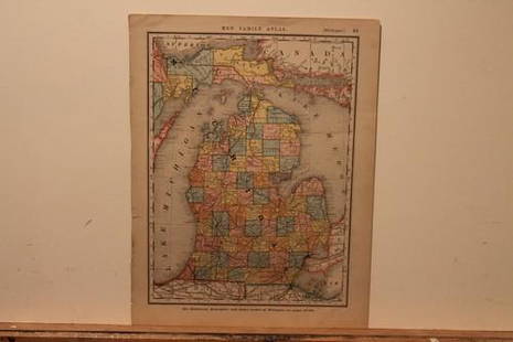
1888 Michigan Map: Title: 1888 Michigan MapAuthor: McNallyMedium: Ink on PaperDimensions: 11"X14"Description: Map of Michigan dated 1888. Printed and published by the McNally Co. in New York. Part of the New Family
0019: 1888 Michigan MapEst. $40-$50Lot Passed
1893 Montana Map: Title: 1893 Montana MapAuthor: WaiteMedium: Ink on PaperDimensions: 21.5"X13"Description: Map of Montana dated 1893. Published by John F. Waite for Gaskell' s Atlas of the World. Double folio. Key
0020: 1893 Montana MapEst. $50-$60Lot Passed
Sold
1885 Washington Territory Map: Title: 1885 Washington Territory MapAuthor: WatsonMedium: Ink on PaperDimensions: 13.5"X11"Description: Washington Territory map dated 1885. Printed and published by Watson in Chicago. Part of his
0021: 1885 Washington Territory MapEst. $40-$50
See Sold Price
1885 Ohio Map: Title: 1885 Ohio MapAuthor: WatsonMedium: Ink on PaperDimensions: 13"X11"Description: Ohio map dated 1885. Printed and published by Watson in Chicago. Part of his World Atlas. Key lower right. With
0022: 1885 Ohio MapEst. $40-$50Lot Passed
1888 North Carolina Map: Title: 1888 North Carolina MapAuthor: CramMedium: Ink on PaperDimensions: 13.5"X11"Description: North Carolina map dated 1888. Printed and published by George Cram in Chicago. Part of his World
0023: 1888 North Carolina MapEst. $40-$50Lot Passed
1888 Minnesota Map: Title: 1888 Minnesota MapAuthor: CramMedium: Ink on PaperDimensions: 11"X13.5"Description: Minnesota map dated 1888. Printed and published by George Cram in Chicago. Part of his World Atlas. Key
0024: 1888 Minnesota MapEst. $40-$50Lot Passed
View:
24
TOP