![(NATURAL HISTORY.) John Gould. A Monograph of the Ramphastidae, or Family of Toucans. [Bound with:]](https://p1.liveauctioneers.com/199/309980/165834109_1_x.jpg?height=300&quality=70&version=1700151649)


Done
New York, NY, United States
Auction Details
Maps & Atlases
This December sale is set to include a wide assortment of maps and graphics chronicling the advancement of knowledge of the world from the sixteenth through the twentieth century. Featured themes will be maps of the American continent from its early colonial settlement, the Revolutionary War. The period of growth and expansion in the West, all the way to some of the earliest established commercial airline flight paths in 1929.
Highlights include a set of unassembled engraved gore segments which construct Vincenzo Coronelli?s enormous 42-inch terrestrial globe from 1688. Several unique manuscript maps will also be on offer, including a neatly detailed hand-drawn account of an extensive hike from New York City through New Jersey and eastern Pennsylvania in the summers of 1860 and 1861 by a recent engineering graduate of the Brooklyn Collegiate Polytechnic Institute, only months before beginning his career as a Navy paymaster during the Civil War.
Auction Curator:
Caleb Kiffer
Specialist, Maps & AtlasesSOLD

0073: (HOLY LAND.) Group of 2 late-nineteenth-and-early-twentieth-century folding case maps.Est.
$600
-$900

SOLD

0075: (HUDSON RIVER.) William Wade. Panorama of the Hudson River from New York to Albany.Est.
$2,000
-$3,000


SOLD

0079: (JAPAN and KOREA.) Giovanni Maria Cassini. Le Isole del Giappone e la Corea.Est.
$500
-$700
SOLD

0080: (JAPAN.) Group of 4 large Edo-period panoramic maps of the roadways, waterways, cities, andEst.
$2,000
-$3,000

SOLD

0082: (JAPAN -- PERRY.) Two large woodblock kawaraban broadsides depicting the entrance of U.S. CommodoreEst.
$1,800
-$2,200
SOLD

0083: (LONDON.) Group of 12 late-nineteenth-and-early-twentieth-century color-lithographed case maps.Est.
$1,200
-$1,800
SOLD
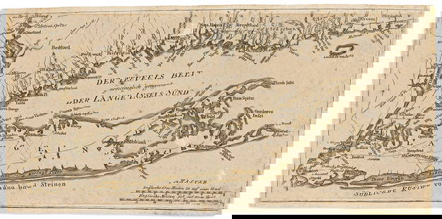
0084: (LONG ISLAND.) Johann Carl Muller. Der Teufels Belt Gemeiniglich Genannt der Lange Insels Sund.Est.
$2,500
-$3,500
SOLD

0085: (LONG ISLAND.) Municipal Realty Corporation. Artworth View of Oceanside Manor and Lawns Situated atEst.
$600
-$900
SOLD
![(LONG ISLAND.) J. Chace, Jr.; and Robert Pearsall Smith. Map of Suffolk Co., L.I. New York.: (LONG ISLAND.) J. Chace, Jr.; and Robert Pearsall Smith. Map of Suffolk Co., L.I. New York. [2 examples]. Hand-colored lithographed wall map of eastern Long Island from Huntington to Montauk Point](https://p1.liveauctioneers.com/199/309980/165833965_1_x.jpg?height=310&quality=70&version=1700151649)
0086: (LONG ISLAND.) J. Chace, Jr.; and Robert Pearsall Smith. Map of Suffolk Co., L.I. New York.Est.
$1,000
-$1,500
SOLD

0087: (MAINE.) George N. Colby; and J.H. Stuart. Plan of Bar Harbor, Mount Desert Island, Maine.Est.
$600
-$900
SOLD

0088: (MAINE.) Plan of the North Eastern Part of the State of Maine Embracing the Settling Lands of theEst.
$500
-$700
SOLD
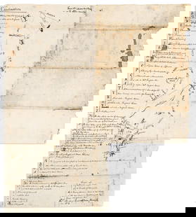
0089: (MANUSCRIPT MAPS.) Eighteenth-century survey of property tracts in Virginia's Northern NeckEst.
$2,000
-$3,000
SOLD

0090: (MANUSCRIPT MAPS.) Samuel B. Massa. Portions of the States of New York, New Jersey and Pennsylvania.Est.
$1,200
-$1,800
SOLD

0091: (MANUSCRIPT MAPS.) Hand-drawn cadastral map detailing land ownership at the intersection ofEst.
$600
-$900

SOLD

0093: (MANUSCRIPT MAPS.) Enormous hand-drawn map of late-nineteenth-century silver mining claims in Aspen,Est.
$1,000
-$1,500
SOLD

0094: (MAP SCRAPBOOK.) Four mid-nineteenth-century hand-colored engraved folding maps tipped to textEst.
$600
-$900


Auction Details

Bid Increments
PriceBid Increment
$0
$10
$150
$25
$500
$50
$1,000
$100
$2,000
$200
$6,000
$500
$10,000
$1,000
$20,000
$2,000
$50,000
$5,000
$100,000
$10,000
$200,000
$20,000
$500,000
$50,000
$1,000,000
$100,000
Preview
Sat, Dec 2 12-5PM Mon, Dec 4 12-5PM Tue, Dec 5 12-5PM Wed, Dec 6 12-5PM
New York, NY 10010
USA
Buyer's Premium
- 30% up to $100,000.00
- 25% up to $1,000,000.00
- 17% above $1,000,000.00
Terms & Conditions
CONDITIONS OF SALE
The property described in this catalogue, as amended by any posted notices or oral announcements during the sale, will be sold by
Swann Galleries, Inc. (Swann) as agent for various owners (the Consignors). These CONDITIONS OF SALE, and the LIMITED
WARRANTY and ADVICE TO PROSPECTIVE BIDDERS set forth elsewhere in the catalogue are the complete and only terms
and conditions on which all property is offered for sale. By bidding at auction (whether present in person or by agent, b y written or
telephone bid, or by any other means) the buyer agrees to be bound by these Conditions of Sale.
1. THE AUTHENTICITY OF PROPERTY LISTED IN THIS CATALOGUE IS WARRANTED TO THE EXTENT STATED IN
THE "LIMITED WARRANTY" EXCEPT AS PROVIDED THEREIN. ALL PROPERTY IS SOLD "AS IS" AND NEITHER
SWANN NOR THE CONSIGNOR MAKES ANY WARRANTIES OR REPRESENTATIONS OF ANY KIND OR NATURE WITH
RESPECT TO THE PROPERTY OR ITS VALUE, AND IN NO EVENT SHALL THEY BE RESPONSIBLE FOR CORRECTNESS
OF DESCRIPTION, GENUINENESS, ATTRIBUTION, PROVENANCE, AUTHENTICITY, AUTHORSHIP, COMPLETENESS,
CONDITION OF THE PROPERTY OR ESTIMATE OF VALUE. NO STATEMENT (ORAL OR WRITTEN) IN THE
CATALOGUE, AT THE SALE, OR ELSEWHERE SHALL BE DEEMED SUCH A WARRANTY OR REPRESENTATION, OR
ANY ASSUMPTION OF RESPONSIBILITY.
2. All bids are to be per lot as numbered in the catalogue.
3. NEITHER SWANN NOR THE CONSIGNOR MAKES ANY REPRESENTATION THAT THE PURCHASER OF
MANUSCRIPT MATERIAL, PHOTOGRAPHS, PRINTS, OR WORKS OF ART WILL ACQUIRE ANY COPYRIGHT OR
REPRODUCTION RIGHTS THERETO.
4. Swann reserves the absolute right (a) to withdraw any property at any time before its actual final sale, including during the bidding, and
(b) to refuse any bid from any bidder. The auctioneer is the sole judge as to the amount to be advanced by each succeeding bid.
5. Any right of the purchaser under this agreement or under the law shall not be assignable and shall be enforceable only by the
original purchaser and not by any subsequent owner or any person who shall subsequently acquire any interest. No purchaser shall be entitled
to any remedy, relief or damages beyond return of the property, rescission of the sale and refund of the purchase price; and without limitation,
no purchaser shall be entitled to damages of any kind.
6. The highest bidder acknowledged by the auctioneer shall be the purchaser. In the event of any dispute between bidders, the
auctioneer shall have the absolute discretion either to determine the successful bidder or to re -offer and resell the lot in dispute. If
any dispute arises after the sale, Swann's sales records shall be conclusive as to the purchaser, amount of highest bid, and in all other
respects.
7. The purchase price paid by a purchaser shall be the sum of the final bid and a buyer's premium of 25% of the final bid on each lot up
to and including $100,000; 20% of the the portion of the hammer price above $100,000 up to and including $1,000,000; and 12% of the
portion of the hammer price above $1,000,000 ("the Buyer's Premium"), plus all applicable sales tax. An additional buyer?s premium may
be charged on any purchase made through a live online auction as posted by Swann in accordance with such live online auction.
8. On the fall of the auctioneer's hammer, title to the offered lot or article will pass to the highest acknowledged bidder, who
thereupon (a) immediately assumes full risk and responsibility therefor, (b) will immediately sign a confirmation of the purc hase
therefor, setting forth his name and address, and (c) will immediately pay the full purchase price therefor. If the foregoing conditions
or any other applicable conditions herein are not complied with, in addition to other remedies available to Swann and the Consignor
by law (including without limitation the right to hold the purchaser liable for the bid price), Swann, at its option, may either (a)
cancel the sale, retaining as liquidated damages all payments made by the purchaser, or (b) resell the property, either publi cly or
privately, for the account and risk of the purchaser, and in such event the purchaser shall be liable for the payment of all deficiencies
plus all costs, including warehousing, the expenses of both sales, and Swann's commission at its regular rates and all other charges
due hereunder. Swann may also impose late charges of 1.5% per month (or the highest rate allowed under applicable law, whichever
is lower) on any amounts unpaid.
9. All property shall be removed from Swann by the purchaser at his expense no later than five (5) days following its sale, and if not so
removed may, at Swann's option, be sent by Swann to a public warehouse at the account, risk and expense of the purchaser. Whether sent to
a warehouse or stored by Swann, the purchaser shall be liable for all actual expenses incurred plus a storage charge of 5% of the purchase
price.
10. Except as noted in this paragraph, all lots in this sale are offered for the account of a third party, without any interest (direct or indirect)
of the auctioneer or Swann. Where Swann or an affiliate of Swann is the sole or partial owner of the property it is noted by the symbol l next
to the description of that lot. Under no circumstances will the Consignor receive any rebate commission. Under no circumstances may the
Consignor bid upon or buy back his property.
11. Except as may be otherwise expressly provided herein, any and all claims of a purchaser shall be deemed to be waived and without
validity unless delivered in writing by registered mail return receipt requested to Swann within thirty (30) days of the date of sale.
12. The rights and obligations of the parties shall be governed by the laws of the State of New York. All bidders and the purchaser submit
to the personal jurisdiction of the New York State courts and their rules and procedures in the event of any dispute.
13. No waiver or alteration of any of these Conditions of Sale, the Advice to Prospective Bidders, the Limited Warranty, the estimates, or
any other matter in this catalogue or any other matter whatever (whether made by the auctioneer, or Consignor, or any representative of
Swann) shall be effective unless it is in writing and signed by a representative of Swann.
14. THE "LIMITED WARRANTY" APPEARING BELOW AND THE "ADVICE TO PROSPECTIVE BIDDERS" APPEARING
OVERLEAF FORM PART OF THESE CONDITIONS OF SALE.
LIMITED WARRANTY
We warrant the authenticity and condition of each lot catalogued herein on the terms and conditions set forth below.
1. Unless otherwise indicated in the respective catalogue descriptions (which are subject to amendment by oral or written
notices or announcements made by Swann prior to sale), we warrant for a period of three (3) years from the date of sale the
authenticity of each lot catalogued herein. (Please note Paragraphs 3 and 5 below.)
2. Except as noted above, or unless otherwise indicated in the respective catalogue description, we warrant for a period of
thirty (30) days from the date of sale to the original buyer of record, that each book or manuscript is complete in text and
illustration and generally is in such physical condition as may reasonably be expected considering the age and provenance.
This warranty does not cover damages to binding, stains or foxing, wormholes, short leaves of text or plates or any defect not
affecting the completeness of the text. Moreover, this warranty does not cover the lack of inserted advertisements, blank leaves,
cancels or subsequently published volumes.
3. Serial publications, books in original parts, extra-illustrated books, made up "albums" and lots described as "sold as is,"
"sold not subject to return," "not collated," "collection of " or "group of," and any lot containing more than three (3) items, are
sold as is and therefore not covered by these warranties.
4. The benefits of these warranties are not assignable and are applicable only to the original buyer of the lot, and are
conditioned on the buyer returning the work in the same condition as at time of sale and in the time period specified.
5. (a) The buyer's sole remedy under these warranties shall be the rescission of the sale and refund of the original purchase
price paid for the item, and this remedy shall be exclusive and in lieu of any other remedy which might otherwise be available
to the buyer as a matter of law.
(b) In the event that a buyer claims that an item is not authentic, Swann shall have no obligation to rescind the sale unless
the buyer has obtained, at the buyer's expense, the opinion of two recognized experts in the field, who are mutually agreeable
to Swann and the buyer, that a lot or portion thereof is not authentic.
ADVICE TO PROSPECTIVE BIDDERS
1. ALL PROPERTY IS SOLD SUBJECT TO THIS ADVICE, THE CONDITIONS OF SALE, AND TERMS OF WARRANTY
PRINTED IN THE CATALOGUE.
2. INSPECTION OF PROPERTY. Prospective bidders or their agents should inspect property prior to the auction. Swann staff are
available to advise prospective bidders at all pre-sale exhibitions and by appointment.
3. BUYER'S PREMIUM. The purchase price payable on any lot purchased will be the total of the final bid plus the Buyer's Premium as
defined in paragraph 7 of the Conditions of Sale, plus all applicable sales taxes.
4. SALES TAX. All items purchased are subject to payment of the New York City and State sales tax of 8.875% on the total purchase
price (final bid plus the Buyer's Premium as defined in paragraph 7 of the Conditions of Sale) unless the purchaser presents proof of exemption
therefrom. An exempt purchaser must provide a properly completed New York State Resale Certificate (Form ST-120) evidencing
possession of a valid New York State Resale or, for non-New York State businesses, the equivalent resale authorization from another
locale. Purchases shipped outside of New York State may be subject to sales tax imposed by another state, and any such sales taxes will also
be due and payable unless proper proof of exemption therefrom is provided. Purchases will not be released unless all sales tax requirements
are satisfied.
5. BIDDING INCREMENTS. $10 up to $150; then $25 to $500; $50 to $1,000; $100 to $2,000; $200 to $6,000; $500 to $10,000; $1,000 to $20,000;
$2,000 to $50,000; and approximately 10% of the current bid thereafter. However, the auctioneer may modify the increments at any time.
6. RESERVES. All lots are subject to a reserve, which is the confidential minimum price agreed to with the seller below which the lot
will not be sold. The reserve will never be higher than the low pre-sale estimate, and will never be lower than half the low estimate. Swann
may implement such reserve by opening the bidding on behalf of the seller and may bid up to the amount of the reserve by placing successive
or consecutive bids for a lot in response to other bidders.
7. ESTIMATES. The estimates provided are intended as a guide to bidding. The figures are educated guesses, based on recent values. A
bid between the listed figures would, in our opinion, have a chance of success (at the time the catalogue was prepared). The estimates are
exclusive of the buyer's premium, and may be revised at any time prior to the auction.
8. BIDDING. All persons attending the auction must obtain a bidding number prior to bidding. If bids cannot be made in person or by an
agent, they may be made by mail, fax. e-mail, or telephone and such bids will be executed without charge.
9. ABSENTEE BIDS will be executed by Swann on the bidder's behalf in competition with other absentee bids and bidding in the room.
Every effort will be made to carry out the bidder's instructions, but Swann shall in no event be responsible for failing correctly to carry out
instructions, and Swann reserves the right to decline to undertake such bids. Bids by mail should be made in U.S. dollars on the bid sheet
found at the end of the catalogue and in accordance with the instructions on the bid sheet.
10. REMOVAL OF PROPERTY. All lots purchased shall be removed at the purchaser's risk and expense by the end of the fifth business
day following the sale. Purchases not so removed will be treated as set forth in paragraph 9 of the Conditions of Sale.
11. SHIPMENT. Upon request, Swann will facilitate the shipping of purchases to out-of-town buyers at an additional charge for packing,
postage and insurance, but will not be responsible for any loss, damage or delay resulting from the packing, handling and shipping thereof.
Unless specific instructions are received, Swann is the sole judge of the method to be used for shipment.
12. PRICES REALIZED. A list of prices realized is published on our website www.swanngalleries.com at the conclusion of the sale. The
Prices Realized is also available at Swann and will be mailed upon request.
13. CREDIT. Bidders whose credit is unknown to Swann should submit acceptable credit references or make prior arrangements for
payment, failing which purchases will not be released until funds have cleared. Mail bidders should submit references or a deposit of 25%
of their maximum bid. If successful, the deposit will be applied to the purchase; if unsuccessful, the deposit will be returned.
14. LOTS NOT RETURNABLE. Paragraph 3 of the Limited Warranty describes lots which are sold as is and not returnable. Books,
manuscripts, prints, drawings, photographs, signatures, or any other property offered in a lot comprising more than 3 items, whether or not
such items are individually named, constitute "Grouped Lots." Such ?Grouped Lots" are not subject to return for any reason.
SUPPLEMENTAL ADVICE TO PROSPECTIVE BIDDERS WITH RESPECT TO SALES OF PRINTS,
DRAWINGS, PAINTINGS, WATERCOLORS, SCULPTURES, AND MULTIPLES
GENERAL:
Dimensions are given in millimeters and inches, with height preceding width in both cases. Dimensions for prints are measured to
the outside edges of the plate mark (for intaglio) or image (for planographic and relief); dimensions for drawings and other works
are measured to the outside edges of the support (paper, canvas, etc.) For prints, if the margins are known or believed to be full this
is stated.
References are cited using the author?s surname and corresponding catalogue page number(s) or catalogue raisonne number at th e
end of each catalogue entry, preceding the estimate.
Whenever possible framed works are sold in the frames in which they have been received. However, we take no responsibility for
frames.
Be advised that pursuant to paragraph 1(b) of the Limited Warranty, Swann does not warrant the condition of prints, drawings or
watercolors unless specifically stated in the catalogue description. We attempt to characterize quality and gross defects in condition
whenever possible as an aid to prospective bidders, but clients should satisfy themselves prior to the sale as to the condition of each
lot and should exercise and rely on their own judgment as to whether the lot accords with its description. More detailed condition
reports are available upon request.
Illustrations in the catalogue are for identification only and should not be used as a basis for determining the condition of the lot.
FOR UNIQUE WORKS, SUCH AS DRAWINGS AND WATERCOLORS:
Authorship for each lot is indicated using the following descriptions:
Guido Reni: In our opinion, a work by the artist. (When the artist?s forename(s) is not known, a series of asterisks, followed by
the surname of the artist indicates that in our opinion the work is by the artist named.)
Guido Reni (attributed to): In our opinion, probably a work by the artist but less certainty as to authorship is expressed than in the
preceding category.
Guido Reni (studio of): In our opinion, a work by an unknown hand in the studio of the artist which may or may not have been
executed under the direction of the artist.
Guido Reni (circle of): In our opinion, a work by an unknown hand closely associated with the named artist but not necessarily his
student.
Guido Reni (style of) or (follower of): In our opinion, a work by an unknown, nearly contemporary or contemporary hand working
in the artist?s style but not necessarily his student.
Guido Reni (manner of): In our opinion, a work in the style of the artist and of a later date.
Guido Reni (after): In our opinion, a copy of a work of the artist.
FOR PRINTS AND MULTIPLES:
If there is a generally accepted title for the print, that title is given at the beginning of the lot description following the artist?s name.
The primary medium is identified following the title. The terms used are intended only as a general description and may not include
all the techniques employed by the artist.
Dates used in the catalogue entries refer to execution of the ?master? or printing matrix. For prints made after 1949, it will be stated
if the impression was pulled later than the execution of the master or matrix; for prints made prior to 1949, the impression may or
may not be of a date contemporaneous with the execution of the master or matrix.
The term ?signed? means that, in our opinion, the signature is by the artist and was made more or less contempora neously with the
creation of the print.
Whenever possible, we attempt to indicate the state of a print and will usually rely on information found in the relevant cat alogue
raisonne to determine this information.
For modern and contemporary prints, and for early prints when the data are available, every reasonable effort is made to identify
relevant information concerning the extent of the edition. If the print is described as an ?artist?s proof? or an ?hors commerce?
impression, the size of the regular edition is usually provided.
In most cases, we describe the quality of the impression of the print, ranging in descending order from ?brilliant? and ?supe rb? to
?very good,? ?good? and ?fair.? These descriptions are intended merely as a general guide and should not be taken as a statement
of fact, nor do they represent any description of the condition of the print.
SUPPLEMENTAL ADVICE TO PROSPECTIVE BIDDERS WITH RESPECT TO SALES OF POSTERS
Posters, for the most part, were printed in large format on the cheapest possible paper, and with an expected life of two to three months on
billboards. They were ephemeral by definition and not intended to withstand the test of time. Therefore, in grading a poster?s condition the
standards and criteria of the print collector cannot be used. The most important element in grading a poster?s condition is its appearance as
defined by the lines, colors and overall design.
Condition in this catalogue is noted according to a rating system which has been accepted by most poster dealers. The following ratings are
used, with an appropriate + or - to indicate slightly better or worse condition:
Condition A: designates a poster much in the same state as when it was printed; the colors are fresh, there is no signifcant paper loss
or tears, but there may be some slight blemish, creases or scuffng.
Condition B: designates a poster in good condition. Some restoration (including repaired tears or slight overpainting) may ha ve been
done but it is not visibly apparent, there may be discoloration and/or fading.
Condition C: designates a poster that is showing the effects of time and/or heavy restoration. Fading and discoloration may be more
pronounced, restoration, folds, creases and flaking may be visible, and there may be paper loss or obvious restored losses.
Within these guidelines, we have done our best to describe any flaws, defects and restoration?whether apparent or not. However,
the above condition ratings are subjective. Prospective purchasers should satisfy themselves as to condition
IF YOU HAVE ANY QUESTIONS REGARDING THESE POSTERS, PLEASE FEEL FREE TO CALL FOR
ADDITIONAL INFORMATION OR FOR A CONDITION REPORT. WE ENCOURAGE YOU TO EXAMINE THE
POSTERS YOURSELF OR TO HAVE THEM EXAMINED BY YOUR REPRESENTATIVE.
ALL POSTERS ARE LINEN-BACKED UNLESS OTHERWISE INDICATED
TOP