


Done
New York, NY, United States
Auction Details
16th-20th Century Antiquarian Maps
Explore both land and sea with this array of maps, which preserves the geography of nearly every region imaginable. Unlike modern maps, these original engravings trace borders as they evolved throughout history. Discover centuries-old views of every corner of America or a map of Portugal and parts of Spain from 1645! Not only will these maps serve as decorative pieces, but they also will reveal innumerable ways to view our world.
Lot Number: Lowest
24

Featured 0002: 1864 Johnson Map of US West -- Johnson's California, with Utah, Nevada, Colorado, New Mexico, andEst. $200-$250Buy Now for $180.00


Featured 0005: 1912 Topographical Map of Kauai, Hawaii -- Topographic Map of the Island of Kauai, Kauai County,Est. $200-$250Buy Now for $160.00

Featured 0007: 1835 Map of the Minnesota River -- A Reconnoisance of the Minnay Sotor Watapah or St. Peter's RiverEst. $200-$250Buy Now for $150.00
Featured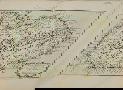 0008: 1764 Bellin Map of Western Guadeloupe in the Lesser Antilles -- Partie Occidentale de l'Isle de laEst. $150-$200Buy Now for $120.00

Featured 0010: 1775-1780 Mauritius, Reunion, and Rodriquez Island. By Bonne & RaynalEst. $100-$120Buy Now for $80.00
Featured 0011: 1764 Bellin Map of Martinique -- Isle de la MartiniqueEst. $150-$200Buy Now for $120.00

Featured 0013: 1850 Tanner Map of Arkansas -- A New Map of Arkansas with its Canals Roads & DistancesEst. $150-$200Buy Now for $120.00


Featured 0017: 1764 Bellin Map of Antigua -- Carte de l'Isle d'Antigue Situee par la Latitude 17 Degres et par laEst. $150-$200Buy Now for $110.00


View:
24
Auction Details

Bid Increments
PriceBid Increment
$0$1
$10$5
$100$10
$200$20
$500$50
$1,000$100
$2,000$200
$5,000$500
$10,000$1,000
$20,000$2,000
TOP